Category: Unseasonably Warm

Pleasant Weekend; Summer-like Feel Next Week…

Highlights:

  • Drier trend develops
  • Warming up
  • Summer-like feel next week

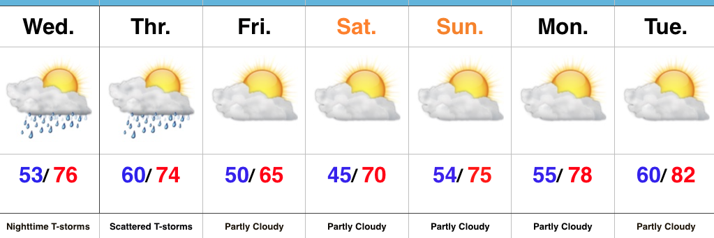
This Is More Like It…High pressure will build into the region over the weekend.  With the exception of a weak disturbance that may kick up a couple showers across northeastern portions of the state Saturday, the balance of the upcoming 7-day period will be rain-free.  This extended dry spell is certainly well deserved and should continue into early next week.  Get out there and make the most of it!

A southwesterly air flow will help transport a warmer and increasingly muggy air mass into the region next week.  While we’ll need to keep an eye on this increasingly moist and unstable air mass for storm chances, we’re siding with a more “optimistic” approach to the forecast period and hold storm chances off until Thursday.  Regardless of storm chances, next week will certainly take on a more summer-like feel…to the delight of many!

Upcoming 7-Day Precipitation Forecast:

  • Snowfall: 0.00″
  • Rainfall: 0.50″ – 0.75″

Permanent link to this article: https://indywx.com/2017/05/11/pleasant-weekend-summer-like-feel-next-week/

Watching For Storms; Drier Times Coming…

Highlights:

  • Couple rounds of storms ahead for some
  • Drier weather awaits
  • Warming up

Nice Day Before Storm Chances Ramp Up Tonight…Once we get rid of the patchy fog this morning, a good deal of sunshine can be expected today before our next chance of storms.  Better rain and storm chances will arrive tonight, especially north of the city.  Locally heavy rain and a strong thunderstorm, or two, can be expected.

Scattered thunderstorms will continue Thursday morning before slowly settling south as we progress into the afternoon hours.  This drier trend to end Thursday will be a prelude to the weekend.  High pressure will build overhead and supply plentiful sunshine over Mother’s Day weekend, along with warmer temperatures.  All-in-all, a well deserved, beautiful weekend awaits.

Dry, warm conditions will continue into early next week.

Upcoming 7-Day Precipitation Forecast:

  • Snowfall: 0.00″
  • Rainfall: 0.50″ -1.00″ (locally heavier amounts)

Permanent link to this article: https://indywx.com/2017/05/10/watching-for-storms-drier-times-coming/

Gearing Up For The “2nd Half…”

Central Indiana has enjoyed a well deserved break in the rain and thunderstorms this afternoon, but, unfortunately, stormy times will return tonight.  With an increasingly moist air mass in place (warm front is currently draped across central IN and slowly lifting north), renewed heavy rain is expected tonight into Sunday.  Dew points will approach 70° and precipitable water values (PWATs) will periodically reach 2″ between this evening and Sunday night.  With that kind of moisture content in the atmosphere, locally heavy, flash flood-producing, rains are a “lock.”  Should you live near a creek, stream, or river, please keep abreast of water levels into early next week and have a plan in place to move to higher ground.

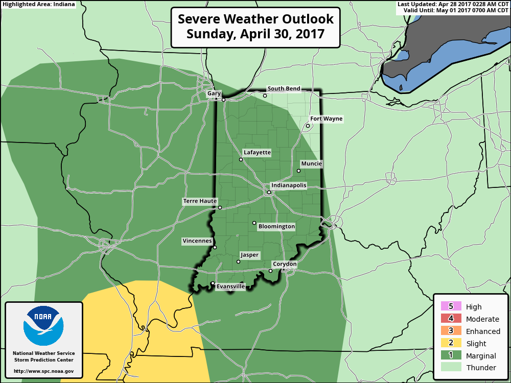
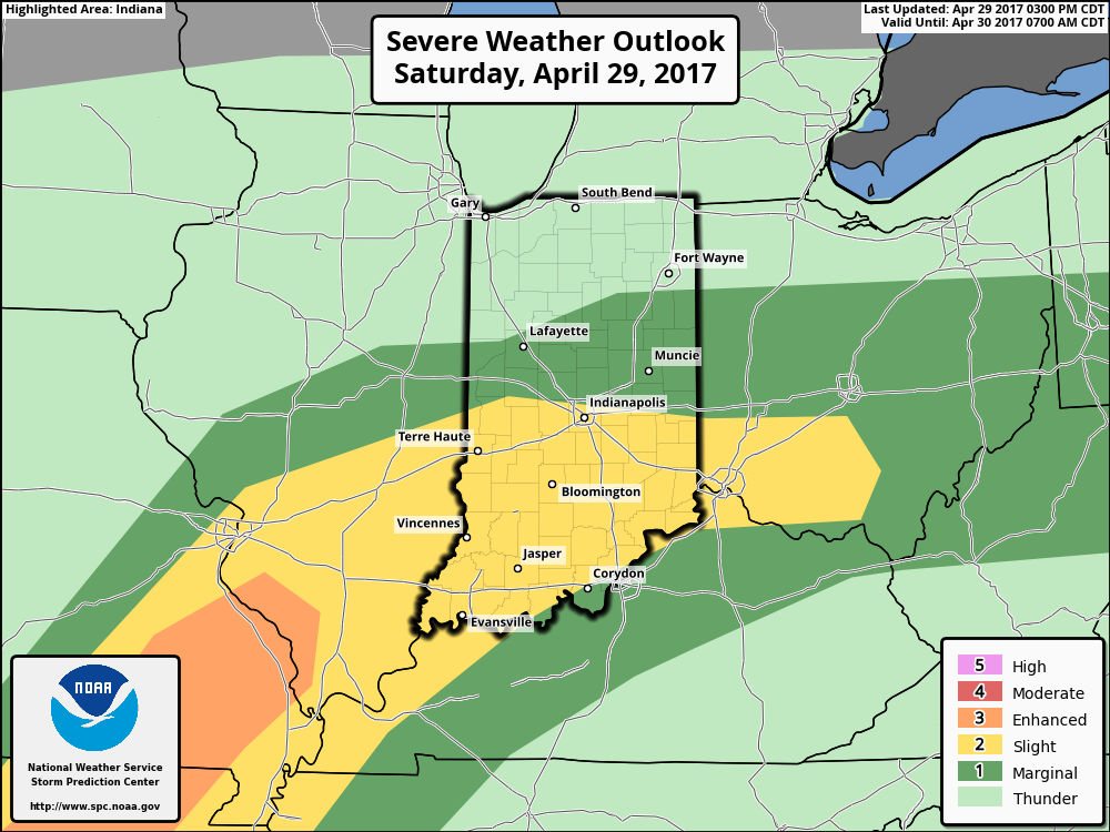
The Storm Prediction Center paints a “Slight Risk” of severe weather across central and southern Indiana tonight.

We think an eastward-advancing line of thunderstorms will blow into central Indiana later this evening (between 9p and midnight).  Some of these may reach strong to severe levels with damaging straight line winds of greatest concern.  Additionally, torrential downpours will occur within this line of storms.

Overall coverage of rain and thunderstorms should diminish Sunday morning before ramping up and increasing in overall coverage and intensity (yet again) Sunday evening and night.  In fact, we may be looking at another severe weather episode Sunday night- again with straight line damaging winds of greatest concern.  By the time all is said and done we expect an additional 1″-2″ of rain across central Indiana with locally heavier 3″+ amounts where storms train over the same area.  Obviously, with saturated soils in place across central Indiana, this amount of rain will create flood concerns into Monday morning.  By the time we get to Monday, the big weather story will be strong and gusty NW winds, much cooler air (falling temperatures through the 50s) and nuisance-level showers.

Another heavy rain maker looms Thursday and we’ll cover that in our updated 7-day later tonight or Sunday.

Permanent link to this article: https://indywx.com/2017/04/29/gearing-up-for-the-2nd-half/

Wet And Stormy Times Through The Weekend; MUCH Cooler Next Week…

While it won’t rain the entire weekend, central Indiana should be prepared for multiple rounds of heavy rain and thunderstorms over the next few days.  For those with outdoor plans this weekend, unfortunately what we’re seeing this evening is only the beginning of stormy times ahead.  There will be periods of dry weather in between the waves of storms, but the big story will be the hefty rain totals come Monday morning and embedded severe storms to boot.

Moisture content continues to increase across central Indiana this evening.
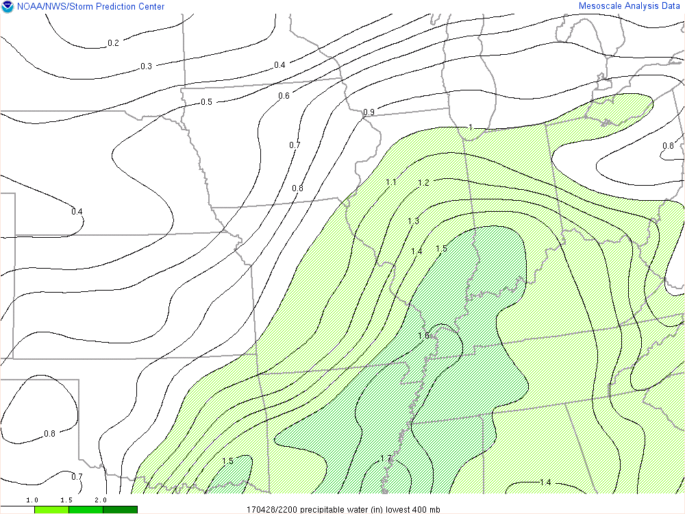
Precipitable water values continue to increase this evening and will aid in locally heavy rainfall tonight and through the weekend.

Forecast radar shows the waves of moisture that will impact the region throughout the night.  We project most widespread heavy rain arrives on the scene Saturday morning.
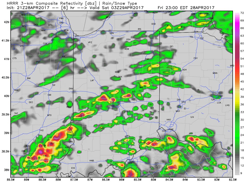
Forecast radar 11p
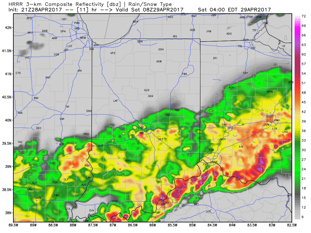
Forecast radar 4a
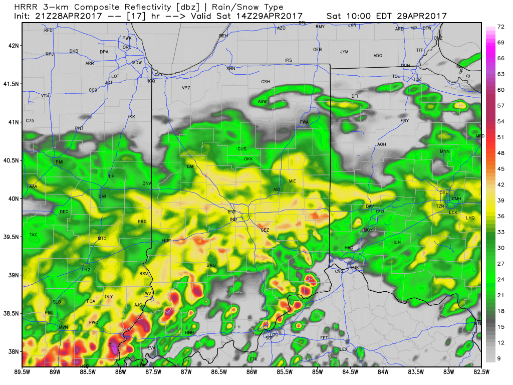
Forecast radar 10a

While scattered strong to severe storms will remain in our forecast Saturday afternoon through Sunday, we think the most widespread rains will diminish as we progress through the afternoon hours Saturday.  That said, with such high moisture content, any storms that develop will be plenty capable of producing locally heavy rainfall in a short timeframe.  It should also be mentioned that as the warm front lifts north, central Indiana will get into an increasingly warm and moist air mass Saturday afternoon and Sunday.  In fact, highs Sunday may approach the lower to middle 80s.  Add in a dew point that will approach 70°, a true muggy, summer-like feel will result.

Overall coverage of thunderstorms is expected to, once again, increase Sunday evening into the overnight period.  Additional heavy rain is expected and with saturated soils in place, flash flooding may result.  If you live near a creek or stream, please pay attention to the water levels into early next week.

The Storm Prediction Center outlines the region for the potential of severe weather tonight through Sunday (don’t be surprised if the “Slight Risk” is pulled further north on Sunday in future updates from the SPC).
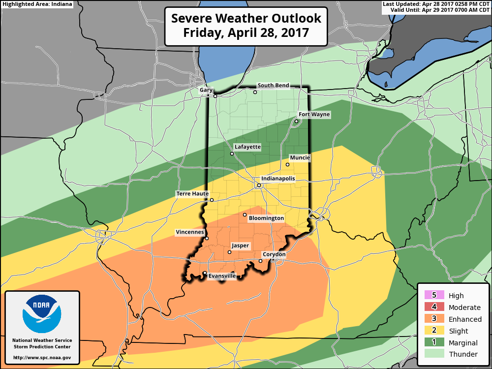
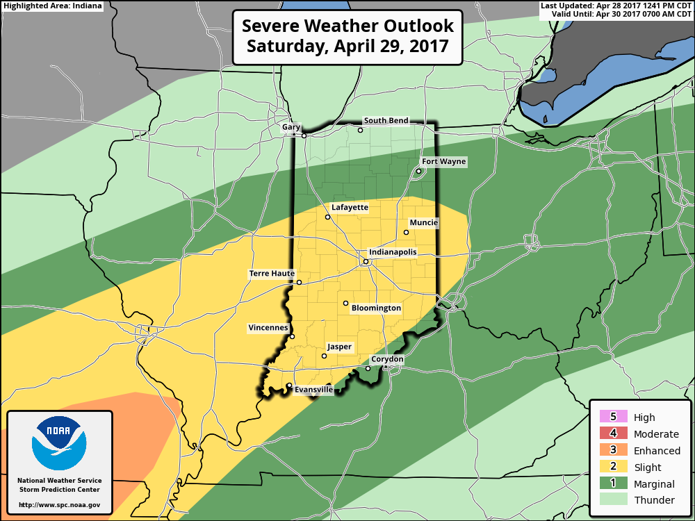
Once all is said and done, we anticipate widespread 2″-3″ rainfall totals through central Indiana, but also note there will be localized heavier amounts.  Once to Monday we’ll look at a much cooler, windy, and “showery” regime.  Look for falling temperatures through  the day Monday and this will set the stage for the week ahead: MUCH cooler, overall….  More on that later this weekend!

Permanent link to this article: https://indywx.com/2017/04/28/wet-and-stormy-times-through-the-weekend-much-cooler-next-week/

Busy Weather Pattern…

Highlights:

  • AM showers then cooler and windy
  • Stormy weekend ahead
  • Cooler next week

Busy Times In The Weather Office…A cold front will sweep through the state this morning with lingering showers and an abrupt wind shift.  Gusty westerly winds and cooler air (we’ve already seen our high for the day) will be with us this afternoon, along with a variably cloudy sky.

Unfortunately, we don’t have many changes to the ongoing idea of hefty weekend rains.  A warm front will begin to slowly lift north Friday into Saturday and this will be the focal point for heavy rain and thunderstorms.  Overall coverage and intensity of rain and thunderstorms will increase as we rumble through the second half of Friday.  A couple of storms could be strong to severe- especially across southern Indiana Friday afternoon and night.

The aforementioned warm front will lift north and be located across the southern Great Lakes region Sunday.  This will put our neck of the woods squarely into the warm and humid air mass Sunday.  Though storm coverage will likely be more scattered in nature when compared to Saturday, heavy thunderstorms will develop, especially during the afternoon and evening hours.  With a deep-rooted tropical connection along with saturated soils in place from early weekend rains, flood and flash flood potential will be high as we go into early portions of next week.

As we open up the work week, we’ll shift gears from a moisture-rich southerly flow to one that’s out of the northwest and much cooler.  Showers will continue through Monday.  Our next storm system will then set it’s eyes on the region by the middle of next week.

Upcoming 7-Day Precipitation Forecast:

  • Snowfall: 0.00″
  • Rainfall: 2.50″ – 3.50″

Permanent link to this article: https://indywx.com/2017/04/27/busy-weather-pattern/

VIDEO: Stormy Wednesday Evening For Some; Weekend Flood Threat…

You must be logged in to view this content. Click Here to become a member of IndyWX.com for full access.  Already a member of IndyWx.com All-Access?  Log-in here.

Permanent link to this article: https://indywx.com/2017/04/26/video-stormy-wednesday-evening-for-some-weekend-flood-threat/

Nice Open To The Week Before A Stormy Finish…

Highlights:

  • Sun-filled open to the week
  • Midweek storms
  • Warm, humid, and stormy weekend

Dry Open To The Week Transitions To A Stormy Finish…High pressure and a refreshing northeast flow will continue to dominate our weather as we open up the work week.  Dry skies will prevail and the crisp mornings will warm quickly into the 70s both today and Tuesday.

A cold front will approach late Wednesday and help showers and thunderstorms increase Wednesday night into Thursday morning.

We’ll be in between storm systems Friday and a pleasant close to the work week will result.  That said, a warm front will lift north and move through the region Saturday and this will help shower and thunderstorm coverage increase significantly Saturday morning.  A much warmer and more humid feel will overspread the area once the front blows through and an unstable airmass will continue to promote shower and thunderstorm chances Sunday.  Locally heavy rains are a good bet this weekend.

Upcoming 7-Day Precipitation Forecast:

  • Snowfall: 0.00″
  • Rainfall: 2.50″ – 3.00″

Permanent link to this article: https://indywx.com/2017/04/24/nice-open-to-the-week-before-a-stormy-finish/

Quiet Open To The Work Week Turns Stormy By Midweek…

After a blustery and chilly Saturday (and temperatures in the upper 30s to start our Sunday), a gorgeous close to the weekend is ahead.  Wall-to-wall sunshine is expected with moderating temperatures this afternoon.  Our average high on the 23rd of April is 66° and we should be very close to that later this afternoon.  Enjoy!

High pressure will remain entrenched over our area as we progress through the early portions of the work week.  This will provide pleasant weather and plentiful sunshine.  With a dry airmass in place, expect significant temperature swings.  Overnight lows in the 40s will quickly rise into the 70s Monday and Tuesday.

High pressure will dominate our early-week weather.

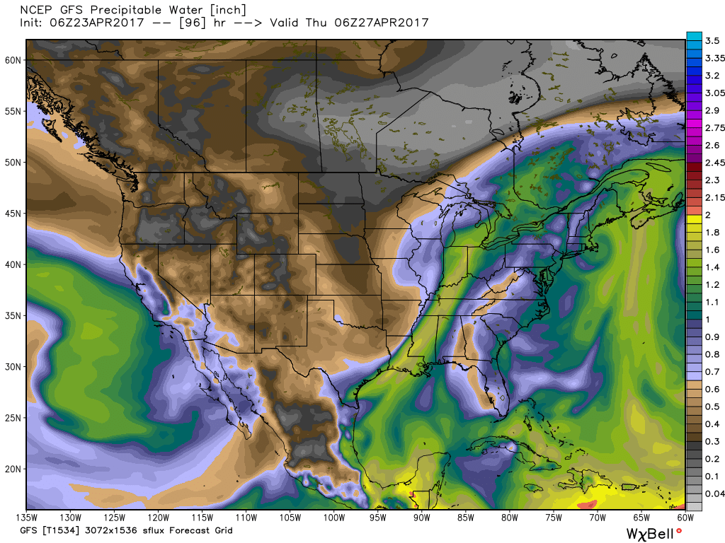
A southerly flow will help pull a more humid air mass northward Wednesday and as a cold front slices into the unseasonably warm and muggy airmass, we expect showers and thunderstorms to increase Wednesday evening into Thursday morning.  We still have some time to watch things evolve, but from this distance, we feel strong to severe thunderstorm potential is present during this period.  Locally heavy rains are also possible as PWATs zoom to 1.5″ +.

Precipitable water values will increase to 1.5″+ Wednesday and support the threat of locally heavy rain.

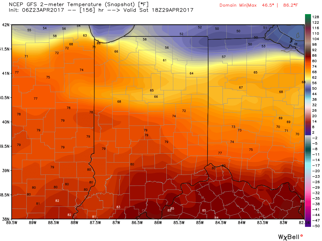
We’ll get into some briefly drier air to wrap up the work week, but a warm front will blow through the region Saturday and will likely be accompanied by thunderstorms as it lifts north.  Once the warm front passes, unseasonably warm and humid air will make a return and set the stage for a true summer-like feel next weekend.  We expect highs to go into the lower to middle 80s with a muggy feel, as well.

Finally, after Saturday morning thunder, we think the majority of next weekend is dry before a cold front brings a return to widespread showers and thunderstorms late Sunday.

Permanent link to this article: https://indywx.com/2017/04/23/quiet-open-to-the-work-week-turns-stormy-by-midweek/

Thursday Storms Before A Cooler Trend…

Highlights:

  • Strong storms possible Thursday afternoon
  • Cooler close to the work week
  • Raw Saturday
  • Delightful open to next week

Thursday Rumbles…While storms have pressed through the northern portions of the state today, we’ve enjoyed a couple days of pleasant weather across most of central Indiana.  That will come to an end Thursday as scattered to numerous showers and thunderstorms develop, especially during the afternoon into the evening hours.  A few of these storms could become strong-to-severe, including damaging wind and large hail potential.  The cold front will pass Thursday night and help usher in a briefly drier and much cooler air mass to close out the work week.

Our next storm system will pass south of the region Saturday and result in thickening and lowering clouds Friday evening, and showers Saturday.  With a stiff east wind, showers at times, and temperatures well below average, we have the makings for a downright “raw” spring day Saturday.  The second half of the weekend will easily be “the pick” as we return to drier air and increasing sunshine Sunday afternoon.

Early next week looks to get off to a pleasant start, including plentiful sunshine and moderating temperatures.

Upcoming 7-Day Precipitation Forecast:

  • Snowfall: 0.00″
  • Rainfall: 0.75″ – 1.25″

Permanent link to this article: https://indywx.com/2017/04/19/thursday-storms-before-a-cooler-trend/

Major Temperature Swings: Summer-Like Mid-Week; Sweater Weather This Weekend…

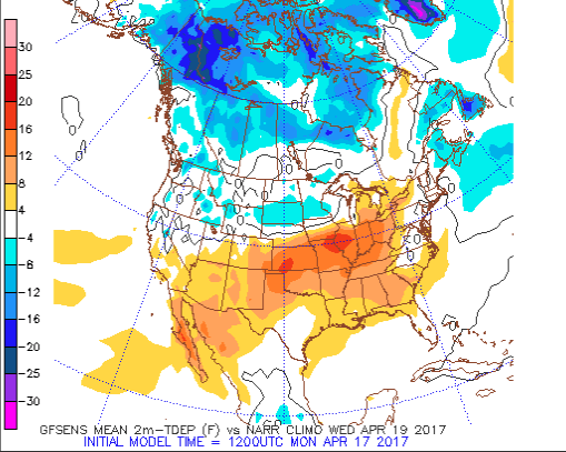
Central Indiana will undergo significant temperatures swings over the upcoming week.  A southerly and southwesterly flow will push an unseasonably warm and moist airmass north to encompass all of the region as we progress through Wednesday and Thursday.

As a cold front slices into the summer-like warmth (highs will approach 80° Wednesday afternoon), scattered showers and thunderstorms will develop late Wednesday into Thursday.
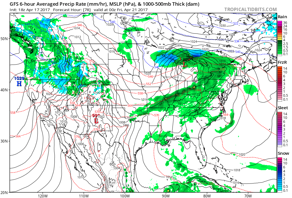
We then will shift gears rather abruptly as we move through the latter portions of the work week and on into the weekend with well below normal chill.  In fact, if current data comes to fruition, most of the weekend will be spent in the 40s.
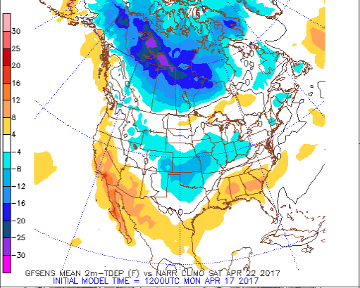
Factor in a stiff northeast wind and periods of rain, we have the makings for a downright “raw” weekend.  We suggest having indoor activities planned this weekend as an extended period of damp, blustery, and unseasonably cool weather awaits.
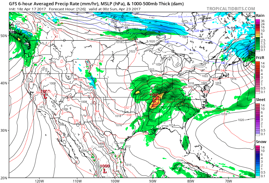
We still have a few days to continue watching the data, but early indications suggest locally heavy rainfall is possible (1″-2″) across the region…

Permanent link to this article: https://indywx.com/2017/04/17/major-temperature-swings-summer-like-mid-week-sweater-weather-this-weekend/

IndyWx.com