You must be logged in to view this content. Click Here to become a member of IndyWX.com for full access. Already a member of IndyWx.com All-Access? Log-in here.
Category: Unseasonably Warm
Permanent link to this article: https://indywx.com/2017/06/30/video-closing-out-june-and-heading-into-july/
Jun 19
Refreshing Open To The Week; Scattered Storm Chances Remain…
 Highlights:
- Feelin’ nice
- Scattered storms remain
- More widespread storms late week
Pleasant Open To The Work Week…A step out the door this morning will reveal a much more pleasant feel than what we’ve grown accustomed to over the past week, or so. Much lower humidity and cooler air will be with us through the day Tuesday. With that said, enough upper level energy will be nearby to spark afternoon and evening showers and embedded thundershowers both today and Tuesday.
Humidity will return for the midweek stretch, and temperatures will also be on the climb. While the weekend looks unsettled, the precise details remain a bit “murky” at this point. We know a cold front will slice into the warm and humid air mass, which will serve as a trigger for more widespread showers and thunderstorms (some with locally heavy rain). Some model guidance wants to get tropical moisture involved (from whatever comes of what’s currently Invest 93L). Stay tuned as we continue to look over the data this week. Regardless, a much cooler and drier air mass will arrive next week…
Upcoming 7-Day Precipitation Forecast:
- Snowfall: 0.00″
- Rainfall: 1.00″ – 1.50″
Permanent link to this article: https://indywx.com/2017/06/19/refreshing-open-to-the-week-scattered-storm-chances-remain/
Jun 17
Tropical Feel; Stormy Later Tonight…
 Highlights:
- Strong storms late tonight
- Turning cooler and less humid
- Unsettled pattern back half of next week
Storms Rumble In Late Tonight…Most of the daytime today will be dry and hot. High humidity will also be with us and will help boost heat indices into the middle 90s. Take it easy outdoors today.
We’ll have to keep a close eye on radar trends upstream tonight as a complex of thunderstorms is expected to erupt to our northwest this evening. This storm complex will track southeast and begin impacting Indiana by late-evening (thinking around 11p, or so, across northwest portions of the state as of now). As we push into the overnight, these storms will continue to settle southeast, including central Indiana. A couple of these storms may be strong and with such high moisture content, locally heavy rainfall is, once again, a good bet.
A couple of showers or thunderstorms will be with us Father’s Day, but outdoor plans shouldn’t be cancelled, as most of the day appears to be dry. It’ll be a cooler day and less humid air will filter into the state Sunday night. This will produce a glorious open to the work week!
Unsettled weather will return by the middle and latter portions of next week, along with a briefly warmer and more humid feel.
Upcoming 7-Day Precipitation Forecast:
- Snowfall: 0.00″
- Rainfall: 1.50″ – 2.00″
Permanent link to this article: https://indywx.com/2017/06/17/tropical-feel-stormy-later-tonight/
Jun 13
“Soupy” Now, But Changes Loom…
 Highlights:
- Scattered storms remain
- Oppressive feel
- Cooler times next week
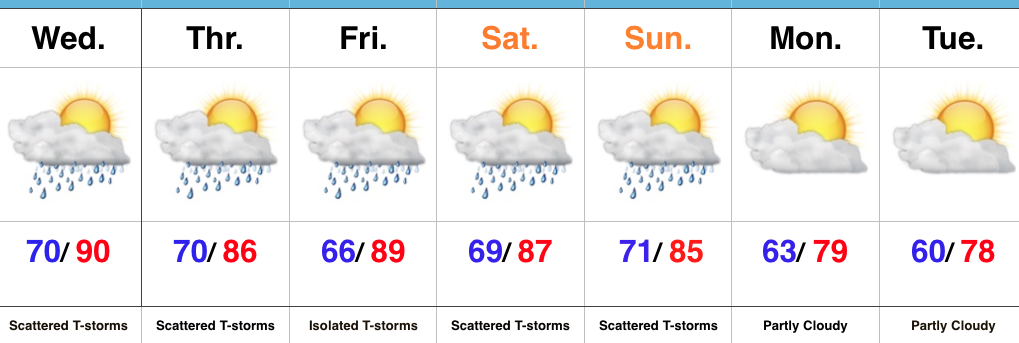
Locally Heavy Storms…We’ll remain locked into a very warm and moist air mass through the remainder of the week, but there’s light at the end of the tunnel. If you’re not a fan of the hot, humid weather, hang in there; next week will offer up a much different feel!
Before we discuss the cooler times that loom next week we still have to face several days of muggy weather and daily scattered storms. With such a “soupy” air mass in place (precipitable water exceeding 2″), any storms will be capable of producing torrential downpours. Similar to that of today, there will be “haves and have nots” over the next few days, but any storms that develop will have the potential of quickly pulsing to strong to severe levels and producing localized flash flooding.
Once to Sunday, a cold front will sweep through the state and finally wash all of the warm and humid air off to the southeast. While scattered storms will remain in our forecast through the weekend, a drier and cooler air mass will arrive on the scene early next week. Hang in there, friends!
Upcoming 7-Day Precipitation Forecast:
- Snowfall: 0.00″
- Rainfall: 1.00″ – 1.50″ (locally heavier totals)
Permanent link to this article: https://indywx.com/2017/06/13/soupy-now-but-changes-loom/
Jun 13
VIDEO: Hot, Humid Weather Gives Way To Better Storm Chances…
You must be logged in to view this content. Click Here to become a member of IndyWX.com for full access. Already a member of IndyWx.com All-Access? Log-in here.
Permanent link to this article: https://indywx.com/2017/06/13/video-hot-humid-weather-gives-way-to-better-storm-chances/
Jun 11
Hot And Humid; Storms Chances Return…
 Highlights:
- Dry conditions continue
- Hot and turning humid
- Storm chances return
Tropical Feel Develops…Pleasant air is on borrowed time and we’ll begin to notice an increasingly muggy feel to the air as early as this afternoon. Dew points will reach oppressive levels Monday into Tuesday (70° and above). With the increased moisture, isolated thunderstorms will develop Tuesday, but most should still remain rain-free. Better shower and thunderstorm coverage will be noted Wednesday into Thursday as a frontal system moves through the state. This won’t be a “uniform” rain, but locally heavy downpours can be expected in the stronger storms. As dry as we’ve been, we’ll take what we can get. It’s a start, at the very least, towards a more active second half of June.
We’ll dry things out briefly Friday before another storm system approaches next weekend. Early indications would suggest next weekend’s storm system will provide more widespread shower and thunderstorm activity.
Tropics: Interesting times appear to be looming in the Gulf of Mexico as we push into the last couple weeks of the month. Models continue to paint various scenarios on potential early season tropical development and any one solution can’t be bought just yet. That said, the overall pattern does seem to want to promote some tropical “mischief” in the coming 10 days, or so.
Upcoming 7-Day Precipitation Forecast:
- Snowfall: 0.00″
- Rainfall: 0.75″ – 1.00″
Permanent link to this article: https://indywx.com/2017/06/11/hot-and-humid-storms-chances-return/
Jun 10
Developing Hot Pattern Doesn’t Last; Cooler And Wetter Times Loom…
Through the short-term, there are two words that will sum up Indiana’s weather: Dry and Hot. We’re entering a stretch where the overall weather pattern will promote an expanding hot dome in the coming days, and put many communities across the state solidly in position to break the 90° mark on multiple days.

Expanding upper ridge means hot times loom late weekend into early next week.
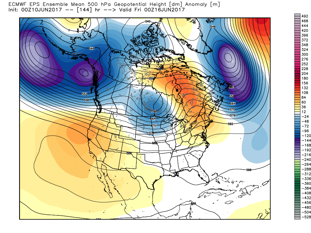
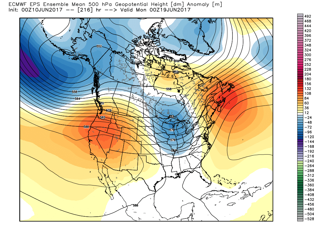
However, this increasingly hot and dry pattern will be a transient one. This morning’s European model shows the evolution to cooler and increasingly wet, unsettled times nicely as we progress into the 6-10 day period.
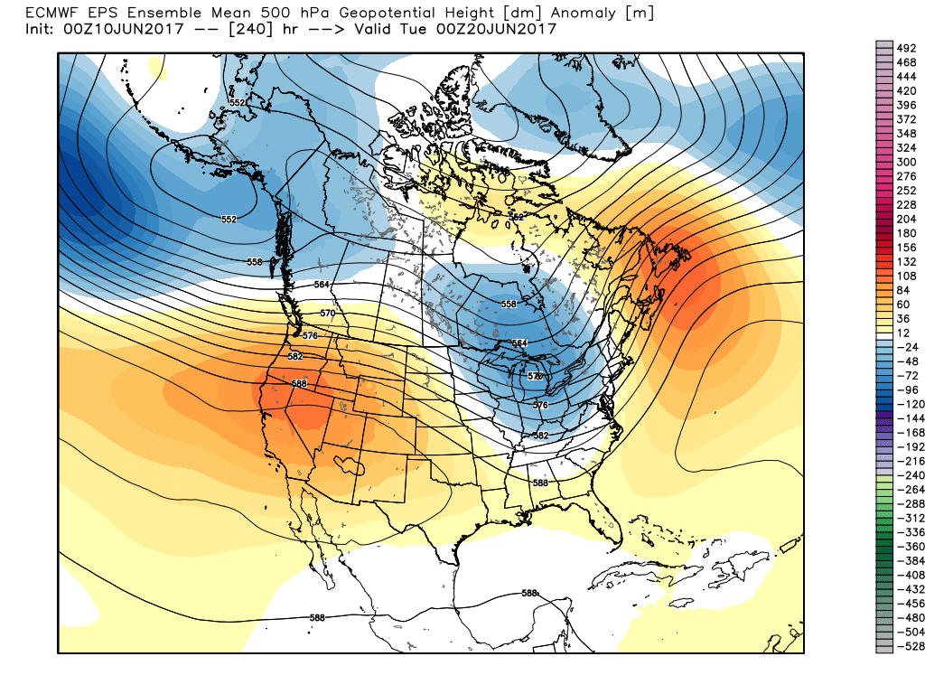
The GFS ensemble would also agree in the overall pattern shift back to cooler and unsettled conditions as early as mid-late next week.
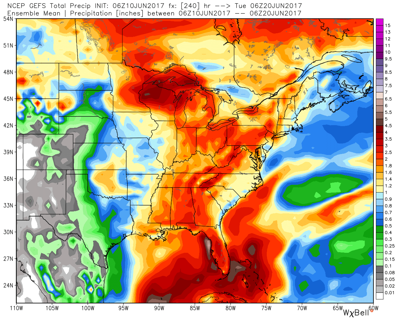
The 10-day GEFS ‘mean’ is a beautiful sight as moisture returns.
Updated 7-day out later this afternoon! Enjoy a beautiful Saturday, friends!
Permanent link to this article: https://indywx.com/2017/06/10/developing-hot-pattern-doesnt-last-cooler-and-wetter-times-loom/
Jun 08
VIDEO: Ready to heat things up this weekend?
You must be logged in to view this content. Click Here to become a member of IndyWX.com for full access. Already a member of IndyWx.com All-Access? Log-in here.
Permanent link to this article: https://indywx.com/2017/06/08/video-ready-to-heat-things-up-this-weekend/
Jun 07
Another Pleasant Day Then It’s Time To Sweat…
 Highlights:
- Another pleasant day ahead!
- Dry weather continues.
- The heat is on!
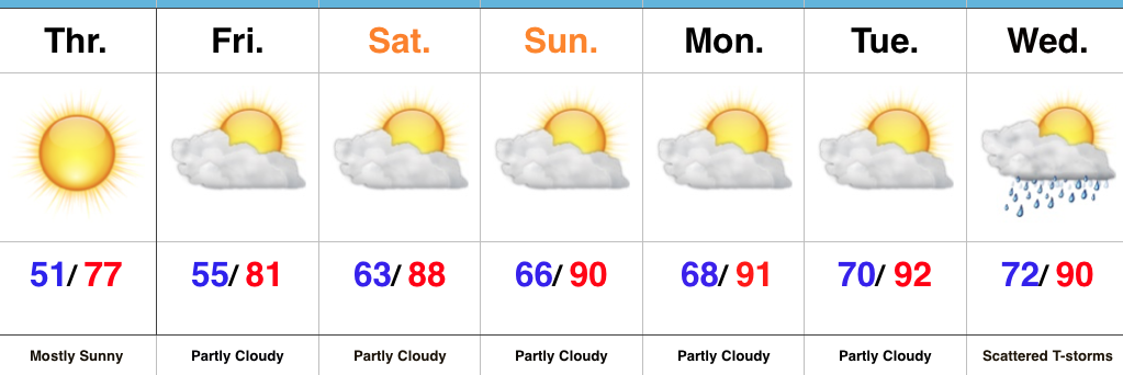
Dry Weather Continues; Summer Feel Develops…We’ll enjoy one more very pleasant and refreshing day Thursday, including plentiful sunshine, low humidity, and below normal temperatures. Many central Indiana neighborhoods will begin the day in the mid to upper 40s away from the city. Enjoy the pleasant weather while we’ve got it!
As we progress into the weekend, temperatures and humidity will begin to increase. By this time next week, overnight lows will be closer to today’s official (IND) high of 72°. One word: YUCK.
A couple of showers and thunderstorms are possible Friday afternoon, but most, if not all, of these look to remain confined to the northern third of the state. That’s the only chance of moisture until we rumble into the middle of next week. In addition to the continued bone dry conditions, unseasonably hot weather will build in over the Mid West and result in highs of 90°, or higher, Sunday into early next week.
Looking into the longer range, a more active and increasingly wet regime looks to return just past mid-month. While the early season heat and dry weather will be significant, thankfully it doesn’t look like it’ll last…
Upcoming 7-Day Precipitation Forecast:
- Snowfall: 0.00″
- Rainfall: 0.10″ – 0.25″
Permanent link to this article: https://indywx.com/2017/06/07/another-pleasant-day-then-its-time-to-sweat/
Jun 06
VIDEO: Pleasant Weather Gives Way To Weekend Heat…
You must be logged in to view this content. Click Here to become a member of IndyWX.com for full access. Already a member of IndyWx.com All-Access? Log-in here.
Permanent link to this article: https://indywx.com/2017/06/06/video-pleasant-weather-gives-way-to-weekend-heat/
