You must be logged in to view this content. Click Here to become a member of IndyWX.com for full access. Already a member of IndyWx.com All-Access? Log-in here.
Category: Unseasonably Warm
Permanent link to this article: https://indywx.com/2017/10/02/video-more-active-times-loom/
Oct 01
Warm Week With Increasing Rain Chances…
 Highlights:
- Dry open to the work week
- Warming trend develops
- Turning more unsettled
Week Opens Dry; Ends Unsettled…High pressure will remain in control of our weather as we open up the new work week. This will supply continued dry conditions along with a warming trend as our refreshing easterly flow transitions to the south.
This southerly air flow will help transport moisture northward as we progress into midweek and a “sluggish” front will begin to impact the area Wednesday evening into Thursday. Scattered showers and thunderstorms will develop and as the front meanders around the region, shower and thunderstorm chances will continue into the weekend. Forecast models differ on the evolution of things over the weekend and result in the sensible weather conditions ranging from more widespread showers and embedded thunder to more of a “splash and dash” variety of rain coverage. We’ll fine tune things as we progress through the week.
Much cooler air is forecast to return just past the current 7-day forecast period.
Upcoming 7-Day Precipitation Forecast:
- Snowfall: 0.00″
- Rainfall: 0.75″- 1.00″
Permanent link to this article: https://indywx.com/2017/10/01/warm-week-with-increasing-rain-chances/
Sep 29
A Note And Some Perspective On Next Week’s New Warm Surge…
After a cool, fall-like, weekend, we still expect a new surge of summer-like air to return next week as a strong (and expansive) ridge of high pressure “balloons” over the eastern half of the nation.
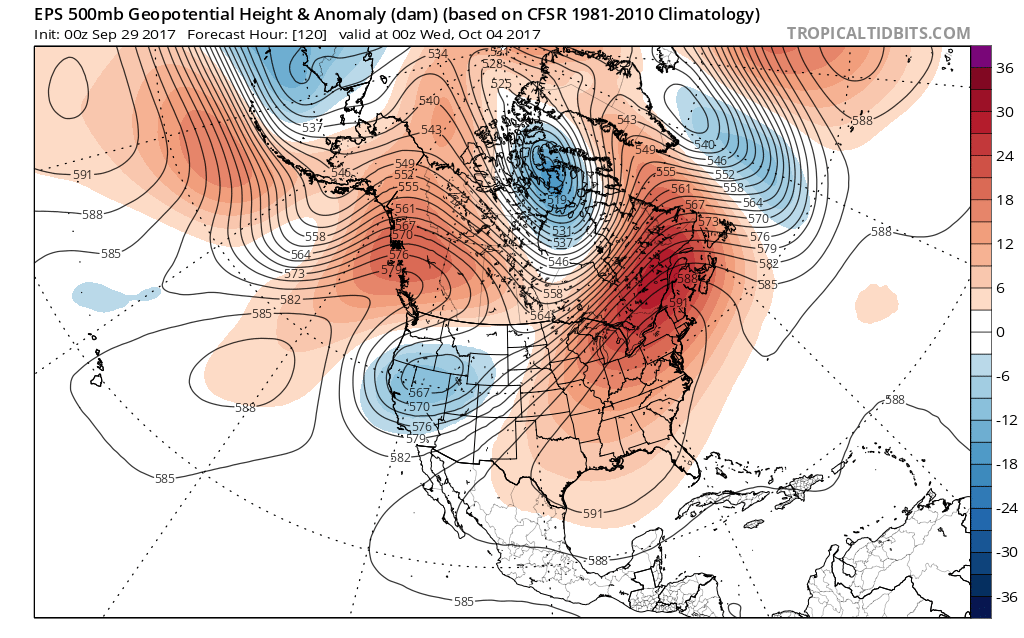 This will be enough to send temperatures into the 85° to 90° range by the early to middle of next week. To shed some perspective on that, our averages for early October include low temperatures in the upper 40s and highs in the upper 60s. For at least a couple of days next week, overnight lows will be much closer to where our afternoon highs should be this time of year.
There are differences on how modeling handles the evolution of things once past midweek. The European model has been jumping on a potential wet weather maker and much cooler trend in the medium term (late next week), but the GFS is having none of that- keeping us dry and hot. We’ll keep a close eye on things over the next couple of days and have a fresh 7-day soon!
Finally, we’re receiving many questions that are centered on whether or not the current overall warm pattern is an indication of what we can expect this winter. The simple and short answer to that question is an emphatic “no.” Transitional seasons are fickle, regardless of ENSO state. Throw in an emerging Nina and all sorts of additional “fun and games” ensue. With that said, there’s no direct correlation specifically between warm (or cold) patterns this time of year and the winter ahead. In fact, there’s been many instances where unseasonably warm Octobers give way to cold winters, and vice-versa.
More later! Make it a great Friday!
Permanent link to this article: https://indywx.com/2017/09/29/a-note-and-some-perspective-on-next-weeks-new-warm-surge/
Sep 28
Finally Feeling Like Fall This Weekend…
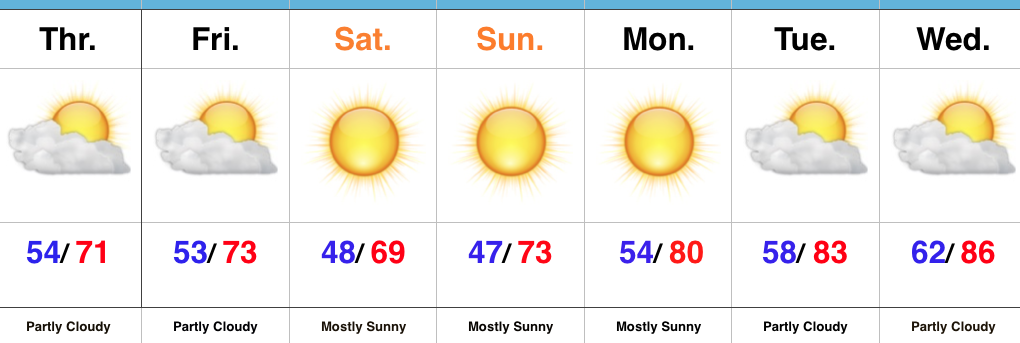 Highlights:
- Cooler start
- Reinforcing cool air arrives Friday evening
- Warming back up next week
This Is More Like It…Cooler air worked into central Indiana overnight behind a cold front. If you ask us, a step out the door this morning feels much better than the past week (we’re ready for fall, y’all)! A reinforcing push of cool air will blow into town Friday evening and result in Saturday being the coolest day of the weekend with most remaining in the 60s for afternoon highs.
As we open up the new work week, our air flow will back around to the south and result in a new warming trend. An expanding ridge of high pressure will lead to continued dry conditions next week, along with unseasonably warm to hot temperatures.
Looking longer-term, there’s really no change in sight in the overall weather pattern through at least early October. That said, there are indications more significant changes loom towards mid-month that could result in more of an impactful shift to cooler times by the second half of the month (warm weather fans, keep in mind the other shoe has to drop sooner rather than later ;-)). As far as precipitation goes, while the short-term doesn’t offer any hope for dry weather relief, we’re confident of a big flip towards a wet pattern by late autumn and winter. Hang in there!
Fall Foliage: The early season cool air we experienced in late August and first half of September ignited early fall foliage across central Indiana. Unfortunately, the recent heat and expected warmer than average pattern through early October will really stunt that fall color change. As things stand now, this fall isn’t shaping up to be one of the better color seasons across the area.
Upcoming 7-Day Precipitation Forecast:
- Snowfall: 0.00″
- Rainfall: 0.00″
Permanent link to this article: https://indywx.com/2017/09/28/finally-feeling-like-fall-this-weekend/
Sep 26
VIDEO: Upcoming 10 Days Looks Warm And Dry, Overall…
You must be logged in to view this content. Click Here to become a member of IndyWX.com for full access. Already a member of IndyWx.com All-Access? Log-in here.
Permanent link to this article: https://indywx.com/2017/09/26/video-upcoming-10-days-looks-warm-and-dry-overall/
Sep 25
Dry Pattern Continues; Cooling Off For The Weekend…
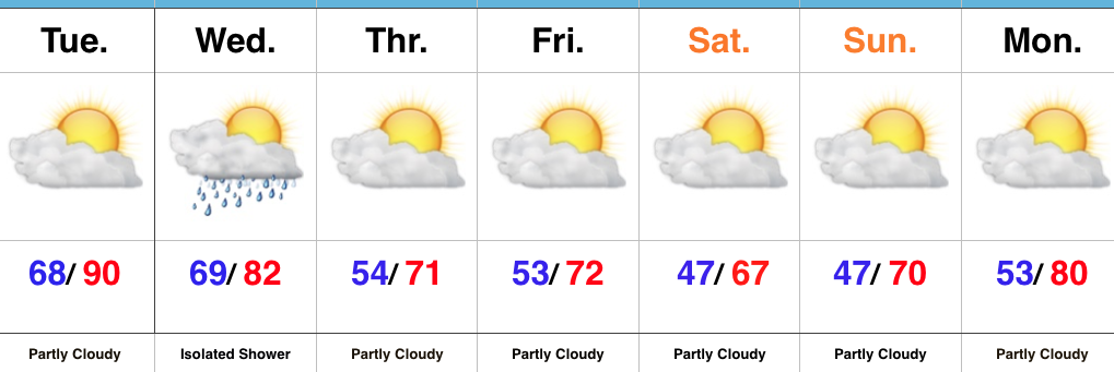 Highlights:
- One more summer-like day
- Fall-like weekend
- Dry weather continues
Cooler Air Inbound…We have one more sultry day to get through as highs near record territory Tuesday with partly cloudy conditions prevailing. A frontal boundary will slip through the state Wednesday, but moisture will be limited with the frontal passage. If you pick up a quick shower Wednesday count yourself lucky. Most will remain rain-free. Cooler air will then settle into the state as we head into the weekend. If you have plans to head out to the pumpkin patch or apple orchard, ideal autumn weather will greet you!
Looking ahead, a new warming trend will develop next week and there’s no significant rainfall in sight, unfortunately.
Upcoming 7-Day Precipitation Forecast:
- Snowfall: 0.00″
- Rainfall: 0.00″ – 0.10″
Permanent link to this article: https://indywx.com/2017/09/25/dry-pattern-continues-cooling-off-for-the-weekend/
Sep 23
VIDEO: Transitional Pattern Over The Upcoming 10 Days…
You must be logged in to view this content. Click Here to become a member of IndyWX.com for full access. Already a member of IndyWx.com All-Access? Log-in here.
Permanent link to this article: https://indywx.com/2017/09/23/video-transitional-pattern-over-the-upcoming-10-days/
Sep 21
Summer Continues Into Next Week Before Cool Changes Take Over…
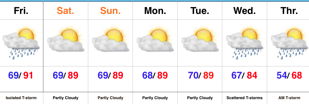 Highlights:
- Summer-like heat continues
- Dry times prevail
- Much cooler air looms
A Little Something For Everyone…If you’re a fan of summer, this forecast has it! If you’re a fan of fall, this forecast has that, too! Summer-like heat will dominate through the short-term with only a slight chance of an isolated thunderstorm today. Most will remain dry and that dry theme will carry us into the new work week ahead. Unseasonably hot (upper 80s to near 90 is downright hot) conditions will also continue as we open up the new week.
That said, a long advertised cold front will push towards the region by midweek and this will provide enough lift to create widely scattered thunderstorms Wednesday into Thursday morning. Significant and widespread rains aren’t, unfortunately, anticipated. The bigger deal will be the much cooler air that will spill into the region Thursday and set the stage for an unseasonably cool open to October.
Upcoming 7-Day Precipitation Forecast:
- Snowfall: 0.00″
- Rainfall: 0.10″ – 0.25″
Permanent link to this article: https://indywx.com/2017/09/21/summer-continues-into-next-week-before-cool-changes-take-over/
Sep 20
Time Is Ticking On This Summer Heat…
There are no changes to our ongoing forecast of “bonus” summer-like conditions into early next week. Highs will continue to zoom into the upper 80s and overnight lows will remain well above average (mid-to-upper 60s). (Keep in mind, averages now feature highs in the mid-70s and lows in the mid-50s).
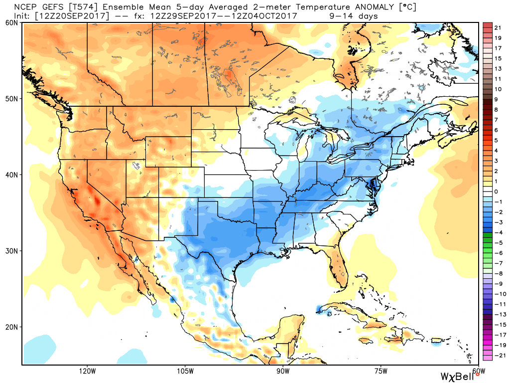
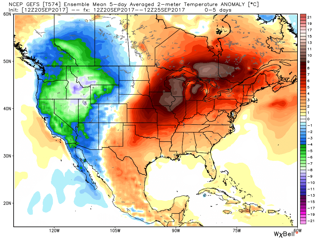 However, a cold front will approach the middle part of next week and while this won’t be an efficient rain producer, it will serve to deliver a return of fall-like air as we close September and open October. From a precipitation stand point, rainfall amounts look “anemic” at best over the upcoming 7-10 days.
At this distance, scattered showers and thunderstorms are possible with the FROPA, but many will remain rain-free and even those that do pick up a shower or storm shouldn’t expect significant rains. What will be a much bigger deal will be the return of an authentic fall feel by next Friday, continuing into early October.
Permanent link to this article: https://indywx.com/2017/09/20/time-is-ticking-on-this-summer-heat/
Sep 19
VIDEO: Summer Dominates Now, But Cooler Times Loom…
Quick video update for you coming live from Santa Rosa Beach, FL!
You must be logged in to view this content. Click Here to become a member of IndyWX.com for full access. Already a member of IndyWx.com All-Access? Log-in here.
Permanent link to this article: https://indywx.com/2017/09/19/video-summer-dominates-now-but-cooler-times-loom/
