You must be logged in to view this content. Click Here to become a member of IndyWX.com for full access. Already a member of IndyWx.com All-Access? Log-in here.
Category: Unseasonably Warm
Permanent link to this article: https://indywx.com/2018/08/28/video-looking-over-the-next-couple-weeks/
Aug 27
VIDEO: Midweek FROPA; Looking Ahead To Labor Day Weekend…
You must be logged in to view this content. Click Here to become a member of IndyWX.com for full access. Already a member of IndyWx.com All-Access? Log-in here.
Permanent link to this article: https://indywx.com/2018/08/27/video-midweek-fropa-looking-ahead-to-labor-day-weekend/
Aug 26
Extended Summer…
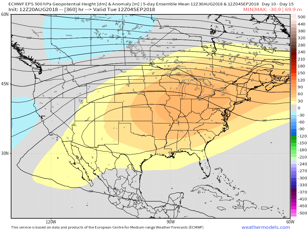
Meteorological fall begins Saturday, but Mother Nature has other plans in store as we move through the next 2-3 weeks. If you’re a fan of summer, you’ll like what’s in store, as a dominant eastern ridge grabs the headlines. Sure, the “axis” of the ridge will retrograde Week 2, but the pattern will likely remain significantly warmer than average through the first couple weeks of September, overall.
Both the GEFS (courtesy of Tropicaltidbits.com) and EPS (courtesy of weathermodels.com) show the overall warm pattern as we approach mid-September.
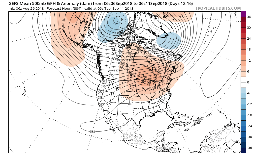
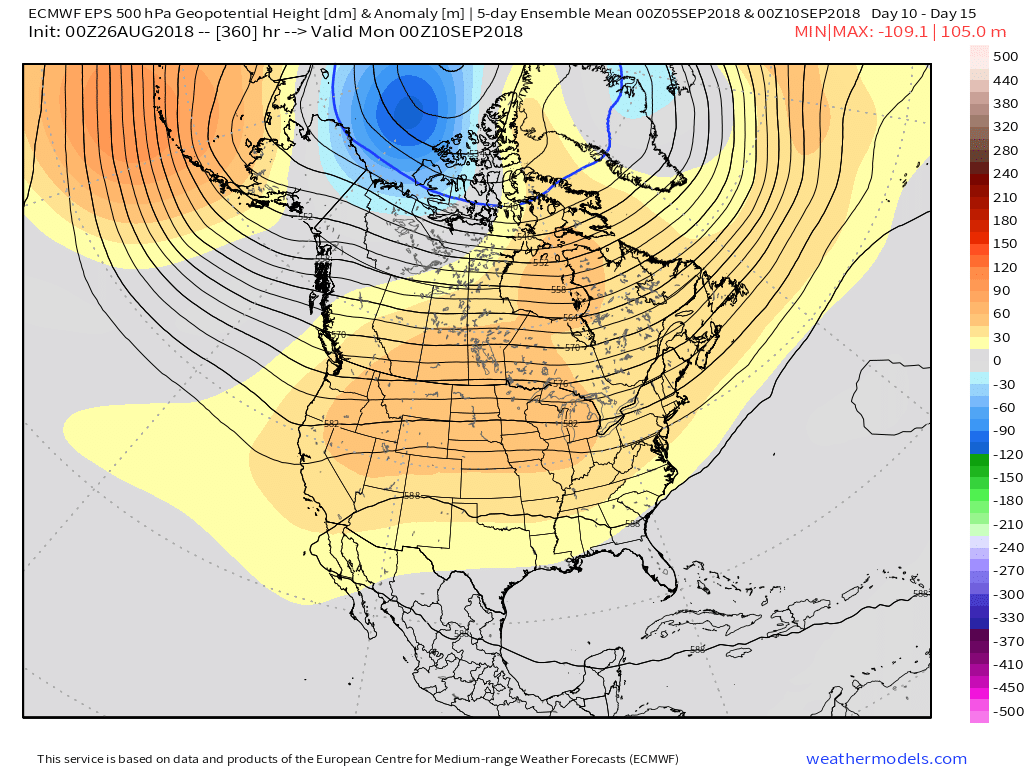 Averages begin to fall in more significant fashion as we transition through the month of September. More specifically, average high temperatures of 83° on the 1st fall to 78° on the 15th. Given the looks of the pattern, highs in the mid to upper 80s (and perhaps a couple of 90° days) will likely be common through the first couple weeks of the new month. Overnight lows will remain oppressive, as well.
If you’re longing for cooler, more fall-like, air, hang in there. Pattern drivers are likely to become more conducive for increasingly refreshing times around these parts as mid-September approaches.
PS: Can you believe we’re only (5) days away from the return of college football?! That alone will help us traverse the next couple weeks of warmer times.
Permanent link to this article: https://indywx.com/2018/08/26/extended-summer/
Aug 25
VIDEO: Stormy Open To Our Saturday; Looking Ahead Towards Labor Day…
You must be logged in to view this content. Click Here to become a member of IndyWX.com for full access. Already a member of IndyWx.com All-Access? Log-in here.
Permanent link to this article: https://indywx.com/2018/08/25/video-stormy-open-to-our-saturday-looking-ahead-towards-labor-day/
Aug 24
VIDEO: Best Rain Chances Along & West Of I-65 Later Today; Humidity Returns…
You must be logged in to view this content. Click Here to become a member of IndyWX.com for full access. Already a member of IndyWx.com All-Access? Log-in here.
Permanent link to this article: https://indywx.com/2018/08/24/video-best-rain-chances-along-humidity-returns/
Aug 23
Cool Now, But Summer Returns- Along With Storms…
You must be logged in to view this content. Click Here to become a member of IndyWX.com for full access. Already a member of IndyWx.com All-Access? Log-in here.
Permanent link to this article: https://indywx.com/2018/08/23/cool-now-but-summer-returns-along-with-storms/
Aug 21
VIDEO: Taste Of Fall Is Replaced With Resurgent Summer Heat…
You must be logged in to view this content. Click Here to become a member of IndyWX.com for full access. Already a member of IndyWx.com All-Access? Log-in here.
Permanent link to this article: https://indywx.com/2018/08/21/video-taste-of-fall-is-replaced-with-resurgent-summer-heat/
Aug 21
VIDEO: Hint Of Fall Blows Into Town Tonight…
You must be logged in to view this content. Click Here to become a member of IndyWX.com for full access. Already a member of IndyWx.com All-Access? Log-in here.
Permanent link to this article: https://indywx.com/2018/08/21/video-hint-of-fall-blows-into-town-tonight/
Aug 20
Heavy Storms For Some Tonight And Looking Ahead…
A warm front is draped across the state this evening. At the same time, surface low pressure is spinning across north-central MO with a trailing cold front entering IL. This evening, a warm and moist airmass continues to advect into central Indiana.
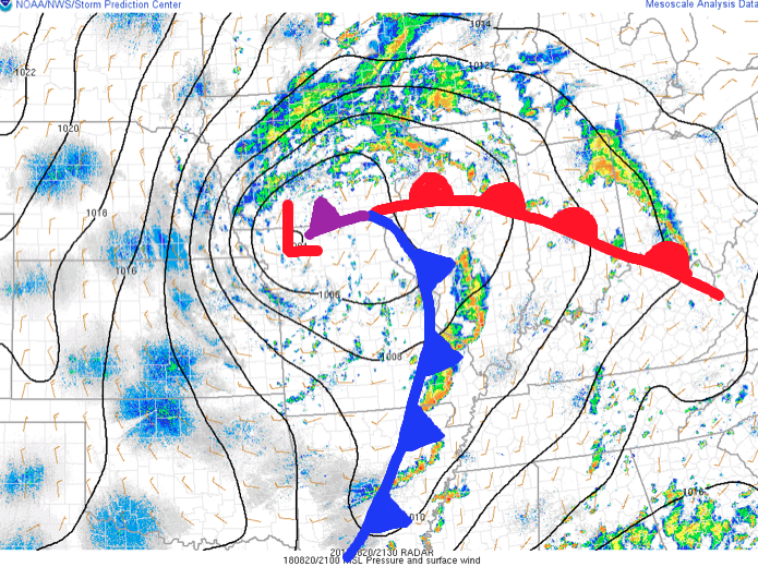 As we type this update, widely scattered thunderstorms are impacting areas from Lafayette to the northeast side of Indianapolis. A more organized complex of thunderstorms is firing to our southwest- from south-central IL to southeastern MO and into AR. This is ahead of the cold front.
Looking at forecast radar products, the majority of data brings a couple rounds of showers and thunderstorms through central parts of the state around 9p to 10p, continuing into the overnight and predawn hours.
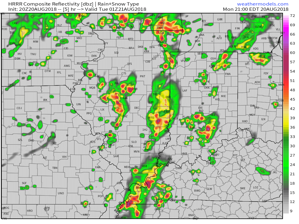
9p forecast radar

11p forecast radar

2a forecast radar
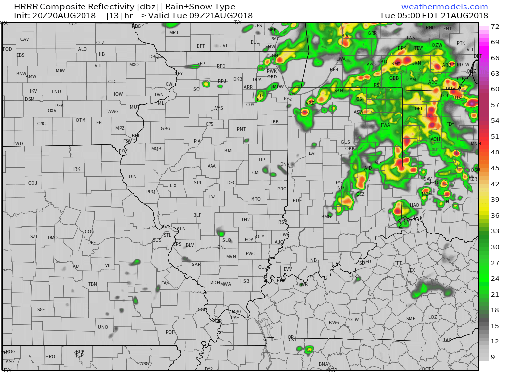
5a forecast radar
With high precipitable water values in place (approaching 2″ through tonight), locally heavy rain is likely with thunderstorms through the night. We expect widespread additional rainfall tonight of 0.50″ to 1″ with locally heavier amounts. A few embedded strong to severe storms are also possible tonight with the primary concern being damaging straight line winds and large hail, but an isolated quick spin-up tornado can’t be ruled out. We suggest ensuring your weather radio is set with the ‘alert mode’ on tonight.
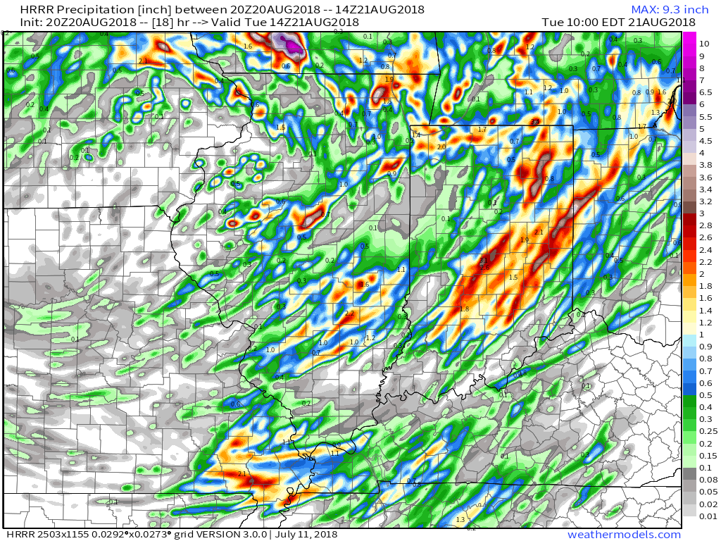
As we flip the page, a few scattered showers will remain in our forecast Tuesday PM before a much cooler and drier air mass invades Tuesday evening- continuing into Friday morning. Several central Indiana neighborhoods will dip into the 40s Thursday and Friday mornings.
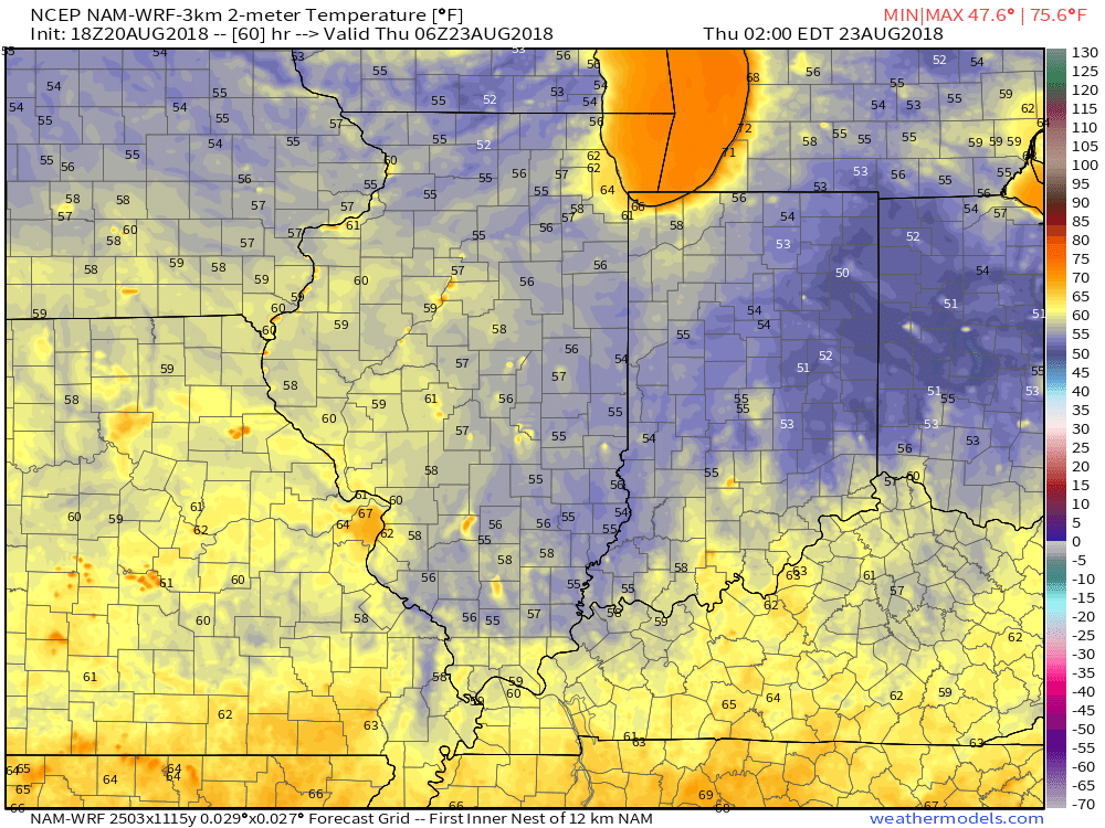
2a forecast temperatures Thursday.
Enjoy the cooler air while you’ve got it, as a developing heat wave will engulf much of the region as we close the month and open September. Needless to say, despite the unofficial end to summer just around the corner, there’s still plenty of summer left in the tank. This is the type pattern that can produce an extended stretch of lows around 70° and highs around 90°.
Permanent link to this article: https://indywx.com/2018/08/20/heavy-storms-for-some-tonight-and-looking-ahead/
Aug 20
VIDEO: Stormy Monday; Hint Of Fall On The Doorstep…
You must be logged in to view this content. Click Here to become a member of IndyWX.com for full access. Already a member of IndyWx.com All-Access? Log-in here.
Permanent link to this article: https://indywx.com/2018/08/20/video-stormy-monday-hint-of-fall-on-the-doorstep/
