LR Discussion: Pattern Discussion Through The Remainder Of October And Into November…

Updated 10.06.23 @ 7:56a

As we type this, we’re in the midst of the season’s 1st big blast of chilly air. These shots will become progressively cooler (colder) in the coming weeks and months. Speaking of that, we’re also working on a post that we’ll unveil over the weekend looking specifically at the upcoming holiday season and what our analog package/ respective SST configuration says we may have in store this season.

For the purpose of this post, we’ll focus squarely on the pattern through the remainder of October.

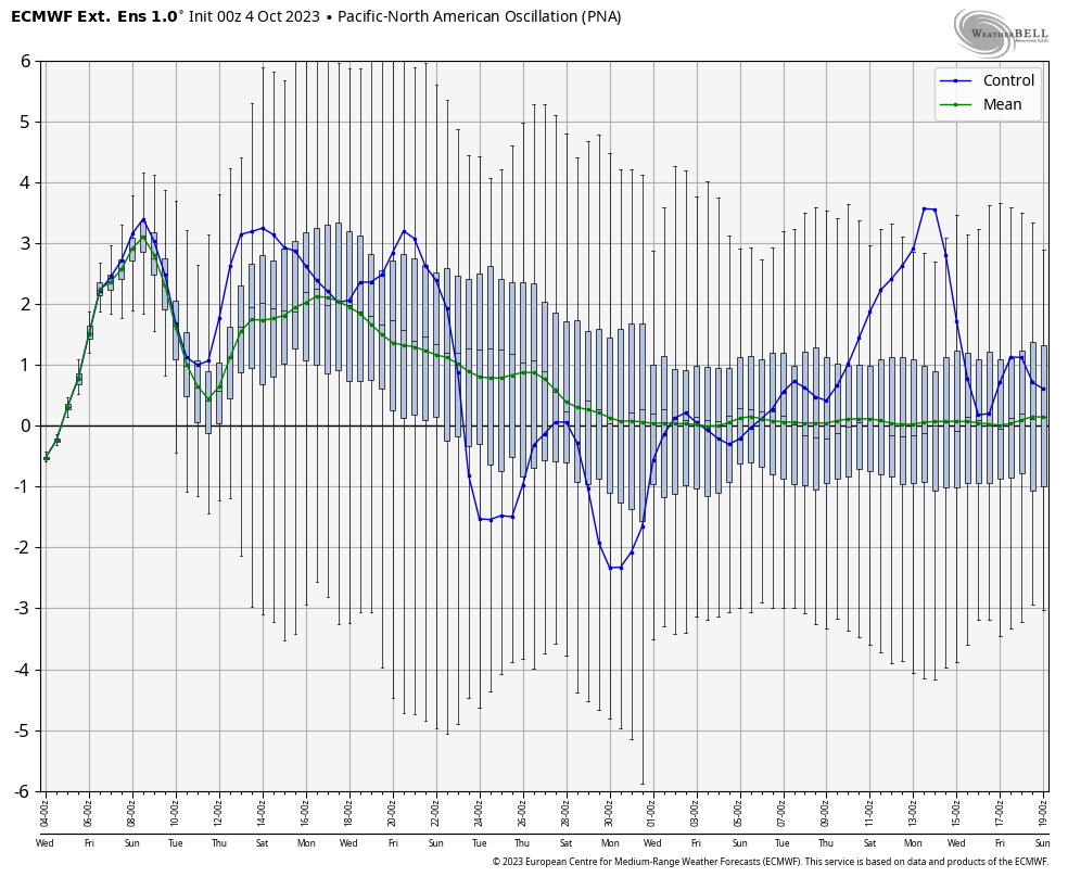
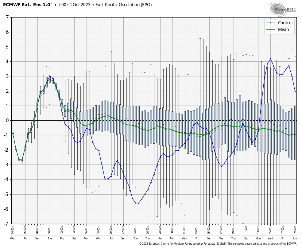
As we typically do, the pattern drivers (+ PNA and – EPO) both suggest a ‘mean’ trough should take up shop across the eastern 1/3 of the country over the next couple weeks. What’s interesting is that the updated European Weeklies also suggest this general theme should continue into at least mid-November. Despite a favorable setup with respect to the PNA/ EPO, the model tries to wash out the chill and hints at a ridge down the road. In my humble opinion, this is the model feeding back on itself and once again showcasing an inability to see below normal temperatures in the longer range. We’ve shown time and time again over the summer and even into the early fall where the model is “forced” to cool the closer we get to a given period and believe that will, once again, be the case this go around, especially with the anticipated positive PNA and negative EPO.

The Pacific North American pattern (PNA) is expected to remain in a positive state through the majority of the upcoming 5-6 weeks.
The East Pacific Oscillation (EPO) is anticipated to remain largely in a negative state through the upcoming 5-6 weeks.

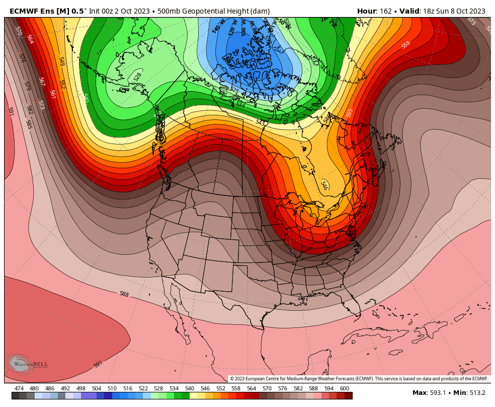
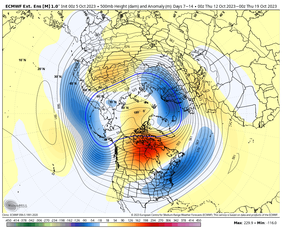
The upper pattern, illustrated with last night’s European Weeklies, is one that breaks the trough down towards Halloween. While there is a possibility of some brief warming around this timeframe, I suspect we’ll once again look back at the model having to correct colder over the east as we rumble into November. More on that in a moment.

Week 1: 10/5 through 10/11

Week 2: 10/11 through 10/18

Week 3: 10/18 through 10/25

Week 4: 10/25 through 11/1

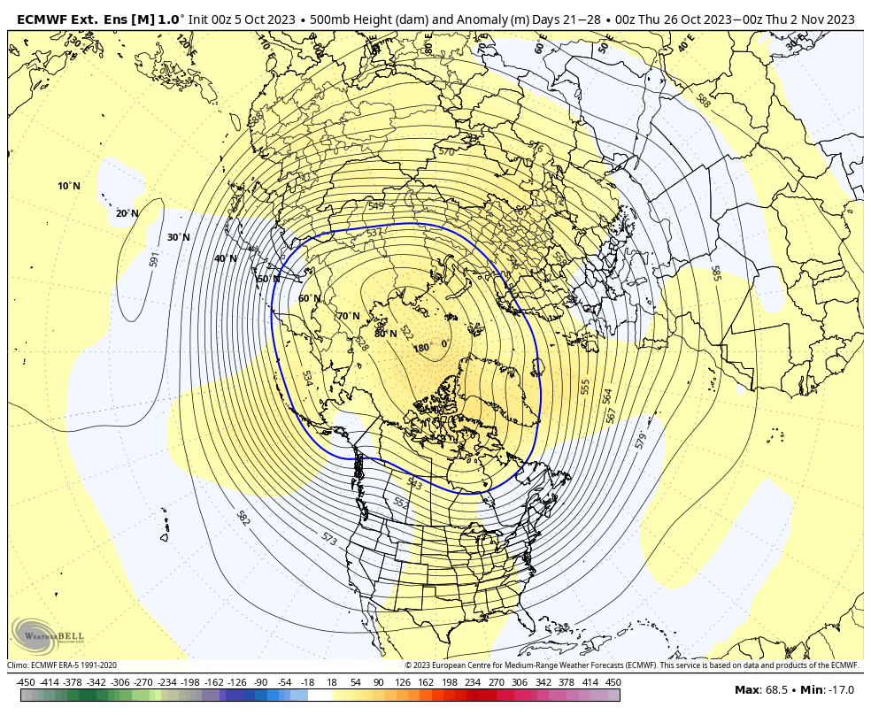
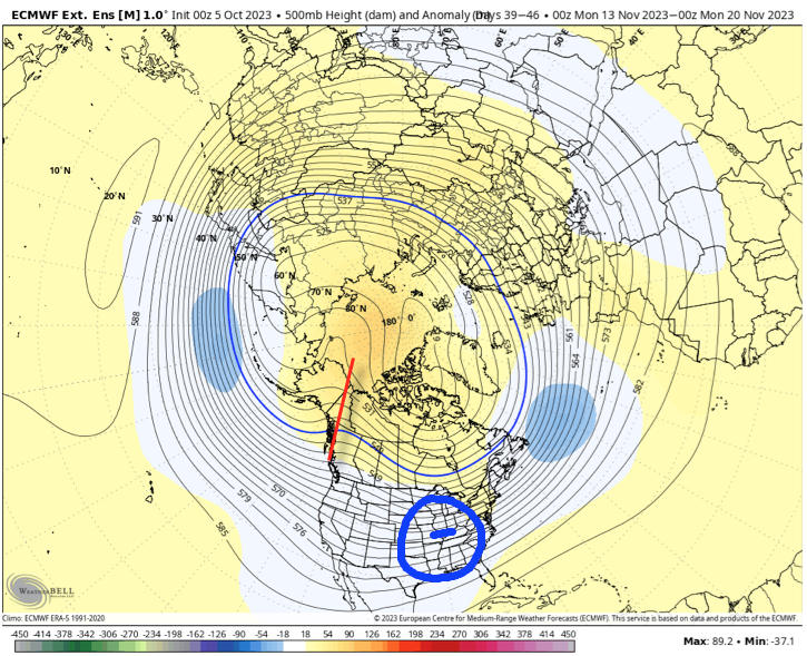
The period ends with a warmer look around Halloween and while this is on the table, it’s also a look that should promote building heights over AK and western Canada and another period of blocking with a subsequent cold trough developing over our neck of the woods and the central/ east as we rumble through into November. The model is seeing the building heights, but not picking up on the magnitude of a downstream trough and associated colder pattern, IMO. Frankly, this 500mb look is capable of producing very cold weather sometime during mid-November and I suspect the model will have to start playing catch up as we move forward.

What Goes Up Must Come Down…

Updated 10.02.23 @ 7:44a

“Severe” clear dominates weather headlines in the short-term. This and the unseasonably warm pattern we’re currently enjoying is a byproduct of an omega blocking pattern. Look for plentiful sunshine and afternoon highs 10° to 15° + above average through Wednesday. The combination of our dry airmass and longer nights will still allow for comfortably cool lows (mid to upper 50s).

A game changing cold front will come plowing through the region Thursday morning. Models have upped the ante a bit with respect to moisture return. We now believe scattered to numerous showers (embedded thunder) will arrive Thursday morning, continuing into the afternoon and early evening hours. Rainfall totals of 0.25″ to 0.75″ seem like a good bet now with this FROPA, with local amounts to 1″. A secondary front will pass Friday night and Saturday morning with even chillier air behind the boundary. Winds will also turn gusty as we open the weekend. By early next week, patchy frost is possible for areas outside of the city, itself.

The bigger “shock” to the system will likely come from the swing in daytime highs. Those unseasonably warm readings will take a nose dive and result in temperatures close to 10° below normal over the weekend into early next week.

’23 – ’24 Winter Outlook: Changing of the Guards…

Published 10.01.23 @ 7a

We do it every year around this time and while some years have certainly been tougher than others, there’s always something special about this time on the calendar. Perhaps it’s the cooler days, the longer nights, the return of football season, or better yet the thoughts (at least to this winter lover) of the first flakes of the season that loom in the not too distant future. However you view this time of year, I hope you can find a way to enjoy the upcoming winter season.

Like most years, there will likely be a little something for everyone, and before diving in too far, we always like to remind folks that long range forecasting is always a challenge, albeit a welcome one at that. While there’s simply no way to be certain about specifics 2-5 months in advance, more times than not, we can at least provide an idea of the overall upper pattern that should generate predominant precipitation and temperature regimes in the colder months ahead.

Without further ado, lets dive in…

We’re in uncharted territory, at least compared to the past (3) years. After a rare triple dip Nina event, a strong El Nino is here and anticipated to stick around, at least in a moderate fashion, through the winter.

It’s important to note that not one Nino event is identical to another. What’s of particular interest with this year’s event is that a lot of the longer range model guidance begins to weaken the Nino as we get into the middle and latter part of the winter, while migrating the warmest anomalies west (more into the central region: region 3 and region 3.4). By the way, here’s an interesting article that sheds more light on the various regions and indices.

Ultimately, that is the golden ticket to what this winter becomes in my opinion. While far from etched in stone, it’s my belief that when you have a Nino event coming off it’s peak during the winter, there’s a better opportunity to get the warmest anomalies more into the central regions as the weakening takes place. Should this happen then we’re talking about increasing prospects of cold and snow. Meanwhile, if the warmest SST anomalies remain tucked into 1+2, it’ll likely be another ugly winter for snow and cold lovers.

On that note, the past 5 winters have only produced an average 14.1″ of snow in Indianapolis. Only ’20-’21 was close to average at 22.2″. To add salt to the wound, if you take out the record snowiest ’13-’14 (whopping 52.2″), our 10 year snow average is 12.6″.

Lets take a look at some of the various modeling for the upcoming meteorological winter (December through February).

JMA Seasonal

European Seasonal

Canadian Seasonal

The seasonal guidance shown above is the most aggressive, collectively, I can recall for quite some time from this distance. Note each of the models above indicate the opportunity for blocking with the active southern stream underneath that we come to expect in an El Nino.

We built our analog set (first shared with Clients on 9/3) with the baseline including 1st year moderate to strong Ninos.

  • 1957-1958
  • 1972-1973
  • 1991-1992
  • 2002-2003
  • 2009-2010
  • 1982-1983
  • 2015-2016

In addition, we’re also looking at critical SST configuration in the NPAC and northwest Atlantic. Out of the list above, heaviest focus centers on ’82-’83, ’91-’92, ’02-’03, ’09-’10, and ’15-’16.

A blend of those years gives us the following temperature and precipitation pattern for meteorological winter:

Temperatures

Precipitation

What does this all mean to me: Central Indiana

Last year we thought the winter would get off to a much quicker, harsher start than years past. While November didn’t disappoint from a snowfall perspective (2.8″ compared to an average of 0.8″), it was still a slightly warmer than normal month. The cold came in December, but it was a “dry” cold with below normal snowfall (1.6″ compared to an average of 6.4″).

The more I look at trends for this winter, the more I like the idea of increased high latitude blocking compared to years past along with the evolving, more central based Nino event. With that said, recent trends have me a bit hesitant to go “all in” on the potential of this winter. We’ll lean slightly warmer than normal with slightly below normal snowfall for the winter as a whole. That said, local perception will be interesting as I envision a snowier winter compared to the past couple years. While the primary storm track should be suppressed this year with below normal precipitation, thanks to the El Nino, that doesn’t necessarily mean we’re in for a snowless winter.

The numbers please…

Temperatures: December through February averaging 0.5° to 1° above normal as a whole

Precipitation: Below normal precipitation is expected through the 3 month winter period (75% of normal is our call) with slightly below normal snowfall. We forecast 20″ of snow (1st flake to last flake).

Whatever the winter provides, I hope you and your family enjoy and stay safe!