Category: Unseasonably Warm

Fun With The MJO…

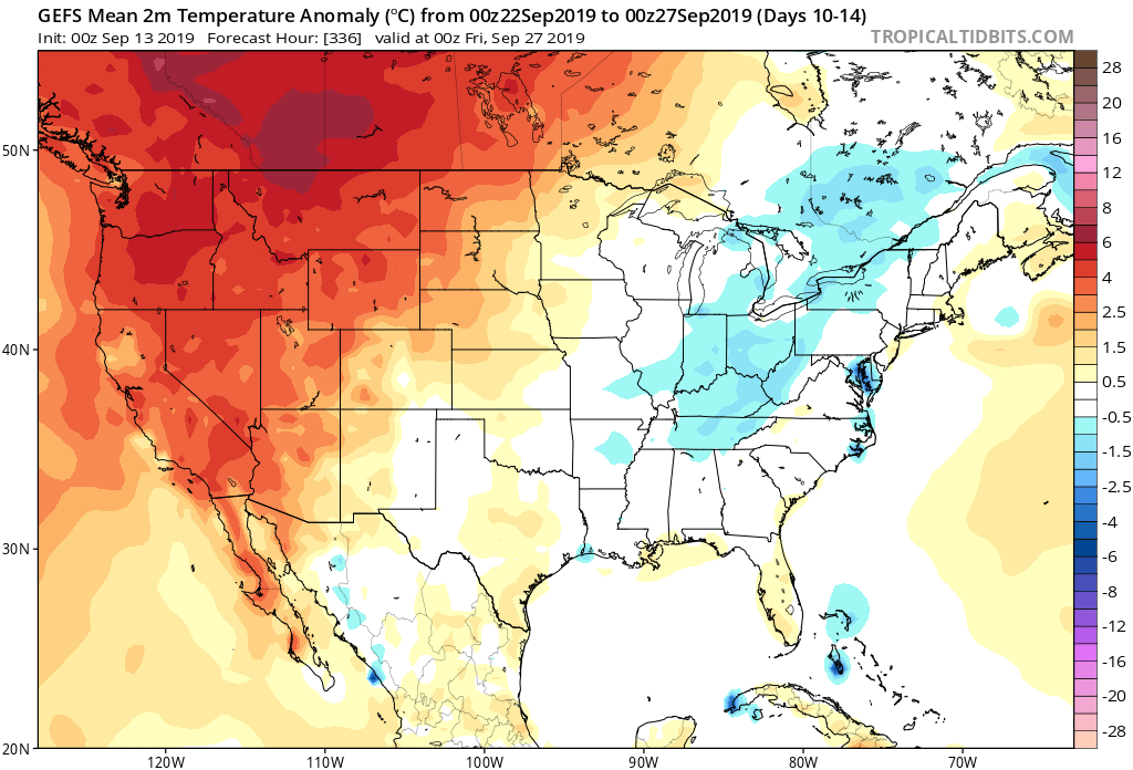
Lovers of fall weather sure don’t want to see Phases 8 or 1 of the MJO in September and October. These are flat-out blow torch phases across the eastern half of the country and sure enough, that’s what we’re forecasting over the better part of the next couple of weeks. With an amplified MJO, we put more stock into this signal than others (EPO, for example) in building out our Weeks 2-3 forecast.

This is not only a warm signal for our immediate region, but a wetter signal as well.
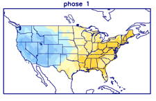
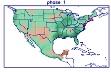
It should be no surprise to see the models paint a very warm picture over the next couple of weeks with this MJO “stalling” in Phase 1. This will lead to a persistent eastern ridge (any cooler air will be very transitional) along with western cold and early snow.

Although things will turn more active, locally, the wettest anomalies should be centered just off to the west and north of our immediate region through the balance of the upcoming 14 days.

While we’ll continue to deal with “bonus” summer-like conditions, the overall pattern from a bigger picture is one that shows fall and winter are, indeed, just around the corner… Note how the snow cover is expected to expand over the next couple of weeks west and north.

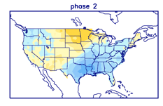
This is worth keeping an eye on. With the MJO showing a tendency to become more amplified, it’s only a matter of time before we swing into the much colder Phase 2 (thinking we need to watch mid-October). Phase 2 in and of itself will be a rather abrupt shift given just how warm we’ll be the next couple of weeks, but when you add in the fact that we’ll likely be looking at a fast start to the snow season, it may come as even more of a shock as the air mass won’t be able to “modify” on its journey southeast.
We’ll continue to closely monitor…

Enjoy your college football Saturday!

Permanent link to this article: https://indywx.com/2019/09/21/fun-with-the-mjo/

VIDEO: Locally Heavy Rain Arrives Sunday Evening; Longer Range Pattern Thoughts Into Mid-October…

You must be logged in to view this content. Click Here to become a member of IndyWX.com for full access.  Already a member of IndyWx.com All-Access?  Log-in here.

Permanent link to this article: https://indywx.com/2019/09/20/video-locally-heavy-rain-arrives-sunday-evening-longer-range-pattern-thoughts-into-mid-october/

VIDEO: Discussing Weekend Rain And Updated Weeks 2-4 Thoughts…

You must be logged in to view this content. Click Here to become a member of IndyWX.com for full access.  Already a member of IndyWx.com All-Access?  Log-in here.

Permanent link to this article: https://indywx.com/2019/09/19/video-discussing-weekend-rain-and-updated-weeks-2-4-thoughts/

VIDEO: Better Rain Chances Arrive Over The Weekend; Longer Range Rambles…

You must be logged in to view this content. Click Here to become a member of IndyWX.com for full access.  Already a member of IndyWx.com All-Access?  Log-in here.

Permanent link to this article: https://indywx.com/2019/09/18/video-better-rain-chances-arrive-over-the-weekend-longer-range-rambles/

MJO/ EPO Telling Of Where The Pattern Is Heading To Close September & Open October?

The short-term period will continue to be dominated by unseasonably warm and dry weather. While we’ll notice a drier air mass (lower humidity) in place the next couple of days, temperatures will remain much warmer than where we should be in mid to late September.

As we close out the month and head into early October, there’s opportunity for a cooler change and we can look to the MJO and EPO for these clues.

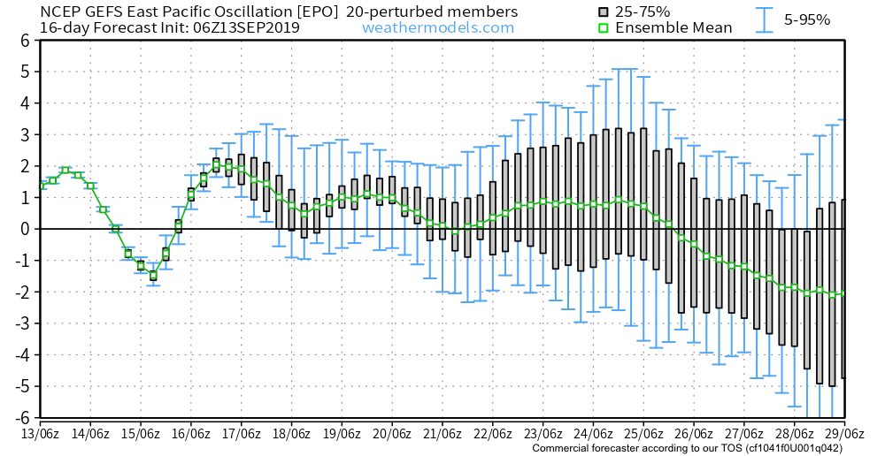
Let’s start with the EPO. The GEFS has been leading the way on the negative transition late September for some time now. The EPS is now trending more strongly negative as of the past couple of days. This argues for a cooler than normal period of weather as we put a bow on September and open October.

(The strongly positive EPO will promote more well above normal warmth in the short to medium term period).

The MJO is becoming more amplified and the result is that we can add another “tool to the belt” moving forward in determining the overall direction of the longer range pattern.


Phase 8 argues for widespread warmth, but as we transition from Phase 1 into Phase 2 (easy to see that’s where the MJO wants to head), cooler air swings into the East/ South.

That transition may also result in needed moisture. Note the wetter period that develops during the movement from Phase 1-2.

Speaking of moisture, Sunday appears to offer up the best chance of widespread, organized rain/ storms we’ve seen month-to-date. Models are keying in on the potential of 0.50″ to 1″ (fingers crossed) as a cold front moves into the region.

The CFSv2 is following the plan outlined above- transitioning towards a wetter and eventually cooler pattern Weeks 2-3.

Sept. 17th-27th temperature anomalies
Sept. 27th-Oct. 7th temperature anomalies
Sept 17th-27th precipitation anomalies

Permanent link to this article: https://indywx.com/2019/09/17/mjo-epo-telling-of-where-the-pattern-is-heading-to-close-september-open-october/

VIDEO: Week Ahead Outlook; Reviewing The New JAMSTEC Winter Update…

You must be logged in to view this content. Click Here to become a member of IndyWX.com for full access.  Already a member of IndyWx.com All-Access?  Log-in here.

Permanent link to this article: https://indywx.com/2019/09/16/video-week-ahead-outlook-reviewing-the-new-jamstec-winter-update/

VIDEO: Generally Quiet Pattern This Week; Late Month Thoughts…

You must be logged in to view this content. Click Here to become a member of IndyWX.com for full access.  Already a member of IndyWx.com All-Access?  Log-in here.

Permanent link to this article: https://indywx.com/2019/09/15/video-generally-quiet-pattern-this-week-late-month-thoughts/

Interesting Test Case In Front Of Us: Euro Vs. Everyone Else…

As we look ahead to late September, there’s a battle beginning to take place in model land. When we pull back the curtain, we note the GEFS and EPS handle the evolution of the EPO in two totally different manners in the Week 2 time period.

The GEFS begins to tank the EPO, suggesting cooler times are ahead to close September.
The EPS maintains a positive EPO and associated much warmer pattern to close September.

Our stand on the evolution of the pattern remains unchanged: that much cooler times will return as we get set to wrap up the month and head into early October. Updated data, aside from the European, suggests we’re on the right track with that train of thought.

JMA Weeklies- Week 2

CFSv2- Week 2

GEFS- Week 2

Permanent link to this article: https://indywx.com/2019/09/13/interesting-test-case-in-front-of-us-euro-vs-everyone-else/

Thursday Morning Rambles: Warmth Continues To Dominate Over The Next 10 Days…

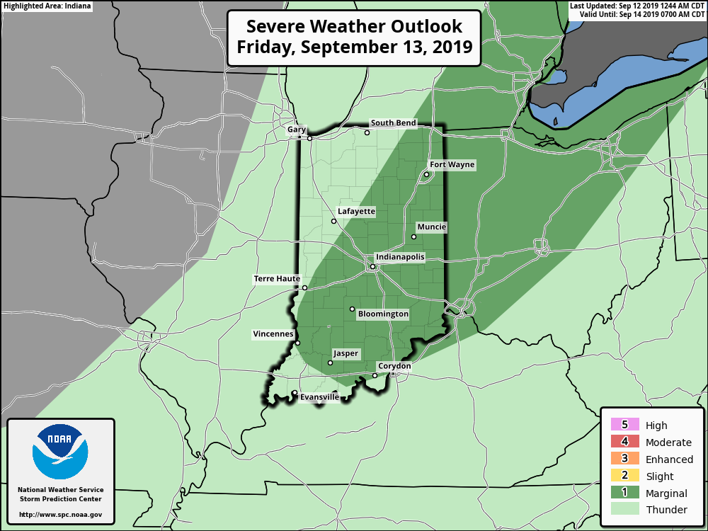
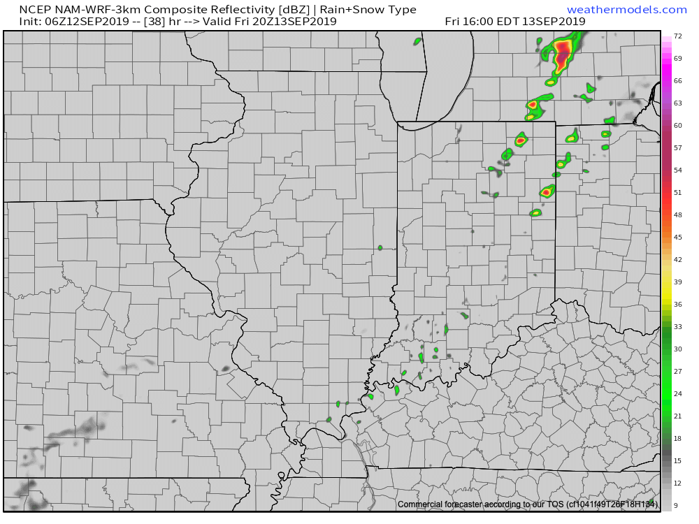
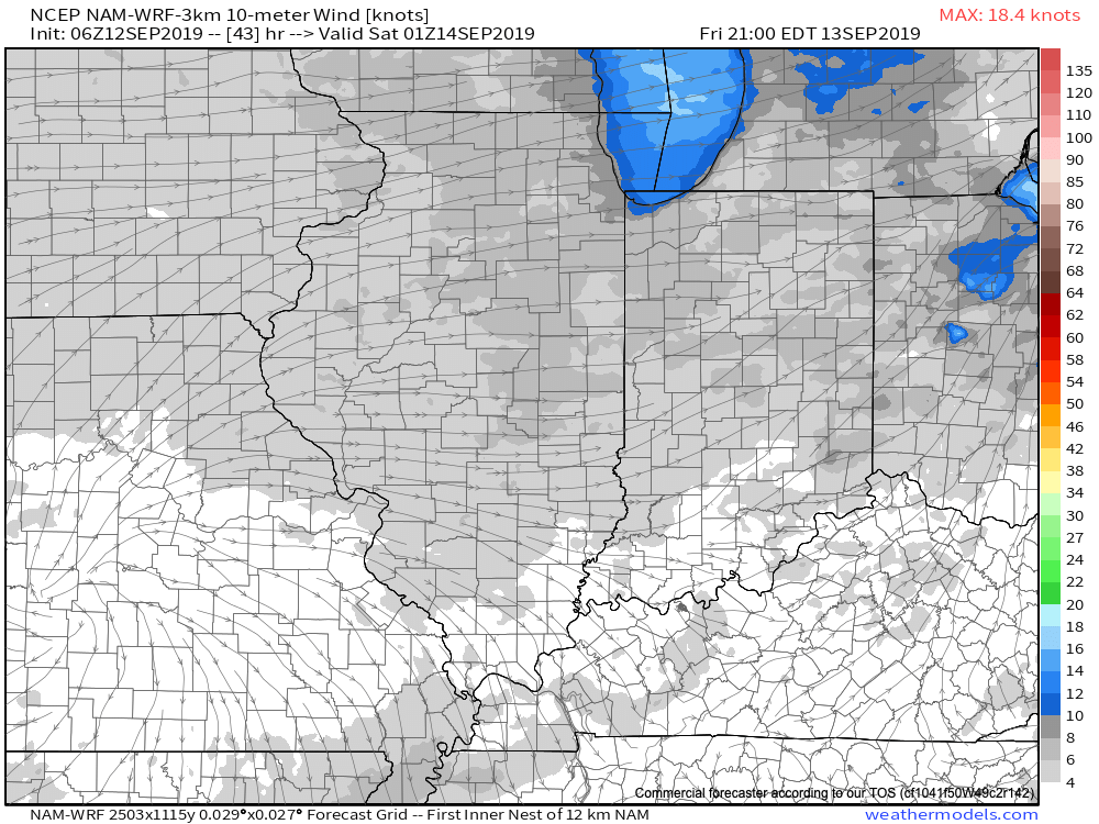
A “cold front” will pass Friday evening. Despite the threat of a couple widely scattered storms this afternoon/ evening, a broken line of storms may accompany the front Friday afternoon and evening. We’re not expecting widespread rain or storm activity with the passage of this front and some yards won’t see a drop of rain over the next couple of days.

A couple of storms may fire up ahead of the frontal boundary Friday afternoon, but widespread rain isn’t expected.
We’ll notice a wind shift from the southwest to west behind the frontal boundary Friday evening.

While somewhat drier air will briefly work into the region Saturday, temperatures will remain well above average. The humidity will return next week.

As we look ahead over next week, generally quiet conditions are anticipated. The big story in the weather department will be the continuation of summer-like heat and an active time of things in the tropics.

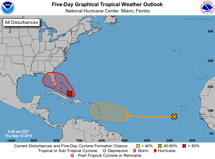
Let’s start with the tropics. Guidance overnight has trended further east with the disturbance that at one time appeared it was heading for the Gulf of Mexico. Instead, our East Coast friends should take note of the disturbed weather in the Caribbean. Some model guidance spins this up into a hurricane over the upcoming weekend as it at least “flirts” with the Southeast US coast (perhaps in an eerily similar fashion as Dorian). The item in the open Atlantic is another we’ll have to keep close eyes on for Week 2 for the Gulf of Mexico. Unfortunately, the upper pattern is a favorable one for the Southeast US coastline to experience a landfall over the next couple of weeks…

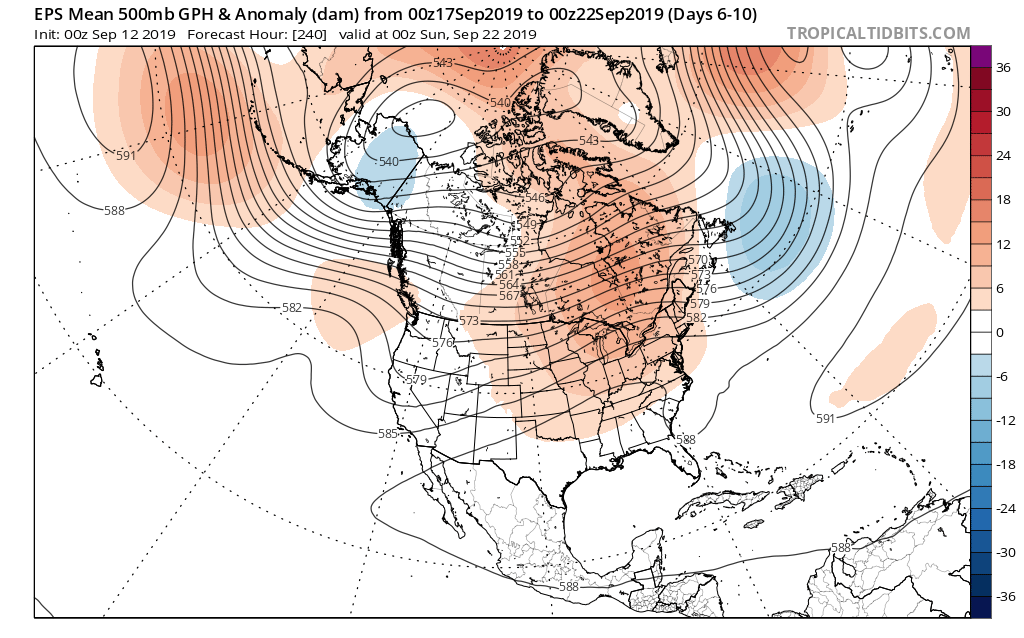
That same pattern through the next couple of weeks is also one that will continue to produce an “extended summer” across the East.

As we look ahead to next weekend, there’s the potential of a stronger cold front offering up more organized rain/ storm chances followed by a stronger cool shot. We’ll have more on this threat in our Weekly AG/ Severe Weather Outlook published this weekend.

Permanent link to this article: https://indywx.com/2019/09/12/thursday-morning-rambles-warmth-continues-to-dominate-over-the-next-10-days/

Looking Ahead To The 2nd Half Of September…

A gorgeous mid September day awaits, with plentiful sunshine and unseasonable warmth. A cold front sits off to our northwest. Meanwhile, a disturbed area of weather in the Bahamas will be monitored for the potential of further development late week into next week as it eventually moves into the Gulf of Mexico.

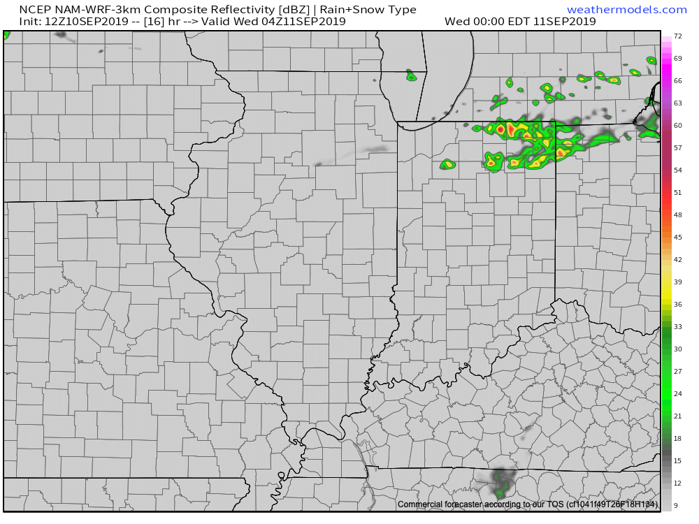
We’ll remain quiet across central Indiana today, but notice a flare up of thunderstorm activity across northern parts of the state tonight. Some of this shower and thunderstorm activity will drift south into central Indiana early Wednesday, but “widely scattered” will be the appropriate word to describe the coverage and many won’t see a drop of rain.

Scattered storms will fire up across northern IN tonight. (Forecast radar midnight Wednesday).

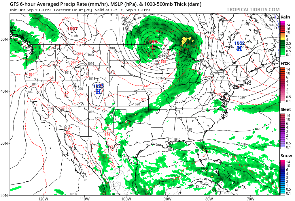
Scattered showers and thunderstorms will remain in the forecast Thursday into Friday before a cold front sweeps through the area. This front will lead to lower humidity as we head into the weekend, but temperatures will remain above average. While some will make it through the rest of the week without seeing a drop of rain, others may pick up 0.25″ to 0.50″ with those scattered downpours.

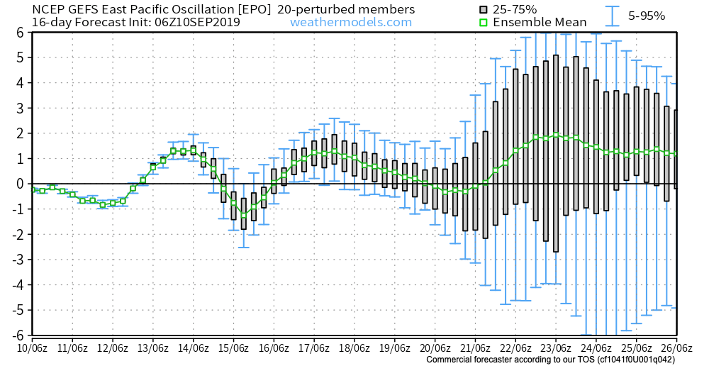
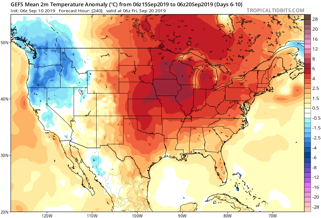
As we look ahead to the 2nd half of September, a warmer to much warmer than average pattern is anticipated to continue. A big reason behind the warmth is the predominantly positive EPO.

A true blow torch of a pattern will result into the late month stretch. Eventually, we should see a pull back of the heights into the NW and western Canada and more of an eastern trough showing up in the means, but this isn’t likely to take place until the last couple of days of this month or early October. Until then, expect an overall summer-like feel.

Permanent link to this article: https://indywx.com/2019/09/10/looking-ahead-to-the-2nd-half-of-september/

IndyWx.com