Updated 04.16.21 @ 7:50a
You must be logged in to view this content. Click Here to become a member of IndyWX.com for full access. Already a member of IndyWx.com All-Access? Log-in here.

Apr 16
Updated 04.16.21 @ 7:50a
You must be logged in to view this content. Click Here to become a member of IndyWX.com for full access. Already a member of IndyWx.com All-Access? Log-in here.
Permanent link to this article: https://indywx.com/2021/04/16/video-late-season-snow-on-the-horizon-updated-thoughts-on-the-pattern-for-early-may/
Apr 15
Updated 04.15.21 @ 7:15a
You must be logged in to view this content. Click Here to become a member of IndyWX.com for full access. Already a member of IndyWx.com All-Access? Log-in here.
Permanent link to this article: https://indywx.com/2021/04/15/video-stronger-cold-front-passes-early-next-week/
Apr 14
Updated 04.14.21 @ 7:49a
You must be logged in to view this content. Click Here to become a member of IndyWX.com for full access. Already a member of IndyWx.com All-Access? Log-in here.
Permanent link to this article: https://indywx.com/2021/04/14/video-keep-those-jackets-handy/
Apr 13
You must be logged in to view this content. Click Here to become a member of IndyWX.com for full access. Already a member of IndyWx.com All-Access? Log-in here.
Permanent link to this article: https://indywx.com/2021/04/13/video-unseasonably-cool-stretch-ahead-targeting-next-week-for-a-hard-freeze/
Apr 13
Updated 04.13.21 @ 7:40a
This afternoon’s Client video discussion will handle the short-term update, including “nuisance variety” rain chances and opportunity of patchy frost late week.
As we look to late month and early May, there’s reason to think the mid-April cool down loses some traction (and perhaps flips to a significantly warmer regime).
We currently have multiple players aligned to support the cool stretch:
MJO in Phase 7
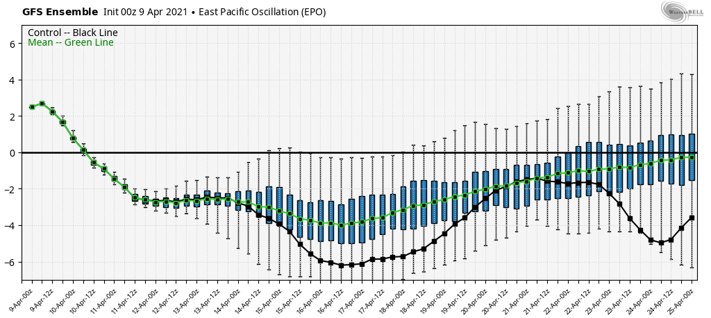
Deeply negative east Pacific oscillation (EPO)
Negative north Atlantic oscillation (NAO)
To no surprise, given the above, we’re looking at an extended period (7-10 days worth) of below to well below normal temperatures.

However, the questions begin to mount by late month as we lose the influence of the negative EPO and the MJO rumbles into Phase 8. This should put pressure on the pattern to at least moderate closer to normal. The one item that’s keeping us a bit shy on buying into a full blown “warm” pattern is the influence of what still looks to be a negative NAO late April and early May. This is still a cool signal, and worth keeping an eye on as we progress deeper into May, itself.
Early thinking here for May (with a lingering negative NAO) is for slightly cooler and drier than normal conditions, locally. We’ll keep an eye on things and update accordingly as we move forward.
In the meantime, enjoy the sunshine that’ll return this afternoon. Full video discussion will be online a bit later today!
Permanent link to this article: https://indywx.com/2021/04/13/mid-month-cool-down-arrives-but-then-what/
Apr 12
Updated 04.12.21 @ 9:45a 4-day rainfall totals checked in between 1.50″ and 1.75″ for most of central Indiana (with a few locally heavier amounts). Despite a couple opportunities for light…
You must be logged in to view this content. Click Here to become a member of IndyWX.com for full access. Already a member of IndyWx.com All-Access? Log-in here.
Permanent link to this article: https://indywx.com/2021/04/12/video-series-of-cold-fronts-pass-through-the-region-several-opportunities-ahead-for-frost-freeze/
Apr 11
Updated 04.11.21 @ 6:45a


Forecast Period: 04.11.21 through 04.18.21
Central Indiana will continue to feel the affects of the low pressure system that resulted in periods of storms yesterday through the remainder of the weekend. A rather persistent light to moderate rain is expected today along with gusty winds and cooler air. This system will pull east of the region Monday and allow for drier air to return. The bulk of the remainder of the forecast period looks dry and seasonably cool. We’ll continue to keep an eye on upper level energy scooting to our east midweek. This is expected to result in a few instability-driven showers for our friends across northeastern IN into OH, but continues to look like it’ll just miss central IN.
Frosty conditions are still possible Thursday morning, especially if we can clear out any lingering clouds from the aforementioned upper energy. The next opportunity for better coverage of light showers won’t come until next weekend. Overall we only expect 0.25” and 0.50” of rain in the week ahead- most if not all of which falls today.
Permanent link to this article: https://indywx.com/2021/04/11/weekly-agwx-and-severe-weather-outlook-27/
Apr 10
Updated 04.10.21 @ 7a
You must be logged in to view this content. Click Here to become a member of IndyWX.com for full access. Already a member of IndyWx.com All-Access? Log-in here.
Permanent link to this article: https://indywx.com/2021/04/10/video-unsettled-weekend-gives-way-to-drier-conditions-next-week/
Apr 09
Updated 04.09.21 @ 8a
You must be logged in to view this content. Click Here to become a member of IndyWX.com for full access. Already a member of IndyWx.com All-Access? Log-in here.
Permanent link to this article: https://indywx.com/2021/04/09/video-saturday-storms-replaced-with-wind-driven-rain-sunday-frost-threat-late-next-week/
Apr 09
Updated 04.09.21 @ 6:45a
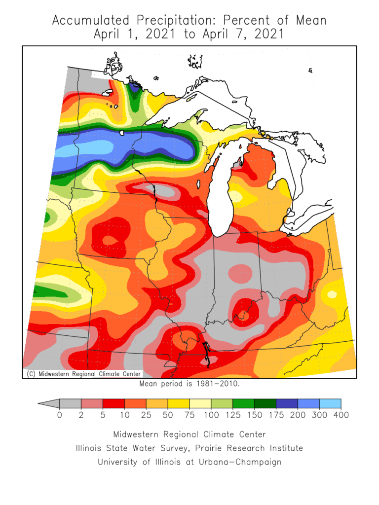
Month-to-date, April has opened up quite warm (little more than 5° above normal) and dry (half inch below normal) across central Indiana.


There are changes on the horizon that will at least result in significantly cooler times ahead. While the transition will be accompanied by an unsettled, wetter stretch, the long range pattern appears to continue the overall recent dry theme.
The drivers behind the cooler shift ahead have to do with the EPO and NAO going negative.


Additionally, the MJO is going to rumble through Phase 7. This is the interesting driver as a stall in Phase 7 would allow for an extended period of colder weather, whereas if things remain amplified and we blow right into Phase 8, the cooler period will be brief. As it is, it appears the latter is more likely from this distance.
That would produce an 8-10 day stretch of cooler conditions (centered on mid-month) before a modifying trend as we close April. Within this cooler stretch a late season frost threat is present towards the middle to latter part of next week.

To reiterate, after the wet period in the short-term, this is still an overall dry pattern (relative to normal) through mid month.

We’ll keep a close eye on the MJO for any potential delay in bringing back the warmth, but the idea here is the look of getting into Phase 8, combined with the NAO and EPO returning to neutral/ positive, milder times should return towards late month.
Permanent link to this article: https://indywx.com/2021/04/09/client-lr-update-flip-on-deck/