Category: Unseasonably Cool Weather

New Work Week; Same Cold Feel…

Mon.

Tue.

Wed.

Thr.

Fri.

Sat.

Sun.

 Status-weather-clouds-icon

 Status-weather-clouds-icon

 Status-weather-clouds-icon

 Status-weather-clouds-icon

 Status-weather-showers-day-icon

 Status-weather-snow-scattered-icon

 Status-weather-clouds-icon

6/ 19

5/ 30

13/ 34

20/ 37

24/ 47

28/ 42

24/ 39

– – –

– – –

– – –

– – –

Light

Light

– – –

Forecast Updated 03.03.14 @ 7:55a

Brrrrrr…It may be a new work week, but the overall weather theme will remain an all-too-familiar one- COLD!  A big, sprawling, area of high pressure will anchor itself over the region and result in temperatures well below where we would typically expect to be for early March.  Instead of a high in the upper 40s, we’ll struggle to reach the 20 degree mark today.  We’ll follow that up with yet another frigid night into Tuesday morning as lows sink to the single digits once more.  Outlying ‘burbs may approach zero tonight and we call that “ridiculously cold” for early March :-).

Midweek Moderation, But Still Below Normal…Temperatures will moderate by the middle of the week, though remain below normal.  We’re monitoring a weak weather system that will scoot north of the region Wednesday and this could move close enough to lead to an increase in cloudiness and a potential flurry or light snow shower Wednesday evening, but most should remain dry.

Keeping An Eye On The Weekend…We’ll continue to closely monitor next weekend.  While model data certainly has yet to reach a consensus, we look to have somewhat of an unsettled weekend- at least on the front end.  Stay tuned as we continue to fine tune things Friday evening into Saturday.

Upcoming 7-Day Precipitation Forecast

  • 7-Day Snowfall Forecast: 1-2″
  • 7-Day Rainfall Forecast:  0.25″

images

For weather updates and more “behind the scenes” data on the go, be sure to Follow Us on Twitter @indywx or become a Friend of IndyWx.com on Facebook!

twic

Permanent link to this article: https://indywx.com/new-work-week-same-cold-feel/

Accumulating Ice And Snow Then Frigid

Sun.

Mon.

Tue.

Wed.

Thr.

Fri.

Sat.

 Status-weather-snow-scattered-icon

 Status-weather-clouds-icon

 Status-weather-clouds-icon

 Status-weather-clouds-icon

 Status-weather-clouds-icon

 Status-weather-showers-day-icon

 Status-weather-snow-scattered-day-icon

16/ 23

9/ 19

4/ 28

10/ 30

18/ 38

27/ 50

22/ 37 

Moderate

– – –

– – –

– – –

– – –

Light

Light

Forecast Updated: 03.02.14 @ 12:25a

Sunday Winter Storm…The well advertised winter storm is here and will make a mess of travel and plans for the second half of your weekend.  Moisture is streaming northeast over a bitterly cold air mass locked in place at the surface and this will create a mixture of sleet and freezing rain to quickly change to a mixture of sleet and snow during the early morning hours across central Indiana.

We forecast precipitation intensity to really begin to increase across the greater central Indiana region around 3-4 am.  Waves of accumulating snow will continue through the day, though it won’t snow all day.  In particular, we bracket 4am to 10am and then again early Sunday afternoon.

Finally, a wave of low pressure will eject into the Tennessee Valley Sunday night into Monday, continuing the significant snow and icing down state.  We anticipate the majority, if not all, of “round two” to bypass most of central Indiana to the south Sunday evening into early Monday.  So, what’s the culprit behind the suppression?  As mentioned in previous posts, a powerful arctic high will build south Sunday into Sunday night and this is the primary driver for the shift south in the surface low track.

All of that said, we’re still looking at significant accumulations of sleet and snow across central Indiana today, though reduced from the 6-8″ forecast we’ve had out since Thursday morning.  We now forecast 2-5″ of snow and sleet across central Indiana.  Needless to say, we’ll continue to monitor.  Sunday night will turn downright frigid across the region as temperatures crash into the upper single digits.

As a quick side note, we once again have to tip our cap to the Canadian forecast model.  It began to catch onto the southward shift with “phase 2” of the storm well in advance of the other model data (during the mid week period), including the highly touted European forecast model.

Frigid Start To The Work Week With Slow Mid Week Moderation…Fresh arctic air will be locked in place across the area to begin the new work week.  While it’ll be dry, temperatures will run as much as 30 degrees below seasonal norms.  The cold winter of 2013-2014 just doesn’t want to let up.

As we push into the mid week stretch we’ll note a powerful Gulf low that’s expected to push up the eastern seaboard. Early indications here keep us dry with slowly moderating temperatures.  Though we’ll remain well below normal, it’ll be a step in the right direction, so to speak, from the frigid early week start.

Weak Late Week System…The early take on late next week shows a cold front moving through Friday afternoon and evening. This may create a few rain showers Friday evening followed by light snow Friday night into Saturday morning as a fresh push of cold air blows into the state.  We have time to watch this and update as needed.

Upcoming 7-Day Precipitation Forecast

  • 7-Day Snowfall Forecast: 2-5″
  • 7-Day Rainfall Forecast: 0.25″

We’ll have fresh thoughts posted here and on our social media accounts through the day.  Have a nice Sunday and God Bless!  You can follow us on Twitter @indywx and become a friend of ours on Facebook by searching IndyWx.com.

Permanent link to this article: https://indywx.com/accumulating-ice-and-snow-then-frigid/

Word On The Weekend And A Couple Other Items Of Interest.

We continue to monitor the goings on for the weekend closely.  As of now we still think snow is the dominant form of precipitation across central Indiana and likely comes in “waves” of intensity from late Saturday night into Monday morning.  Significant snowfall totals are possible, but it’s still too early to pin point totals due to the chance of some mixing issues (sleet, freezing rain) for some and the overall placement of the cold front.  This will be a bit different than what we’ve experienced with our last couple of winter storms and could be more of a prolonged event as warmer moist air overruns the cold air at the surface.  Again, exactly where the arctic boundary stalls Saturday night into Sunday will determine the precise precipitation types and exactly who sees snow versus sleet and freezing rain.  Stay tuned.

In other news…if you thought it’s been a cold winter then you’d be correct. In fact, this “cool” image from IEM shows that central Indiana has been at 32 degrees, or lower, between 60-70% of the time since December 1st.  Impressive, for sure!

BhaPsoICIAAP9Md

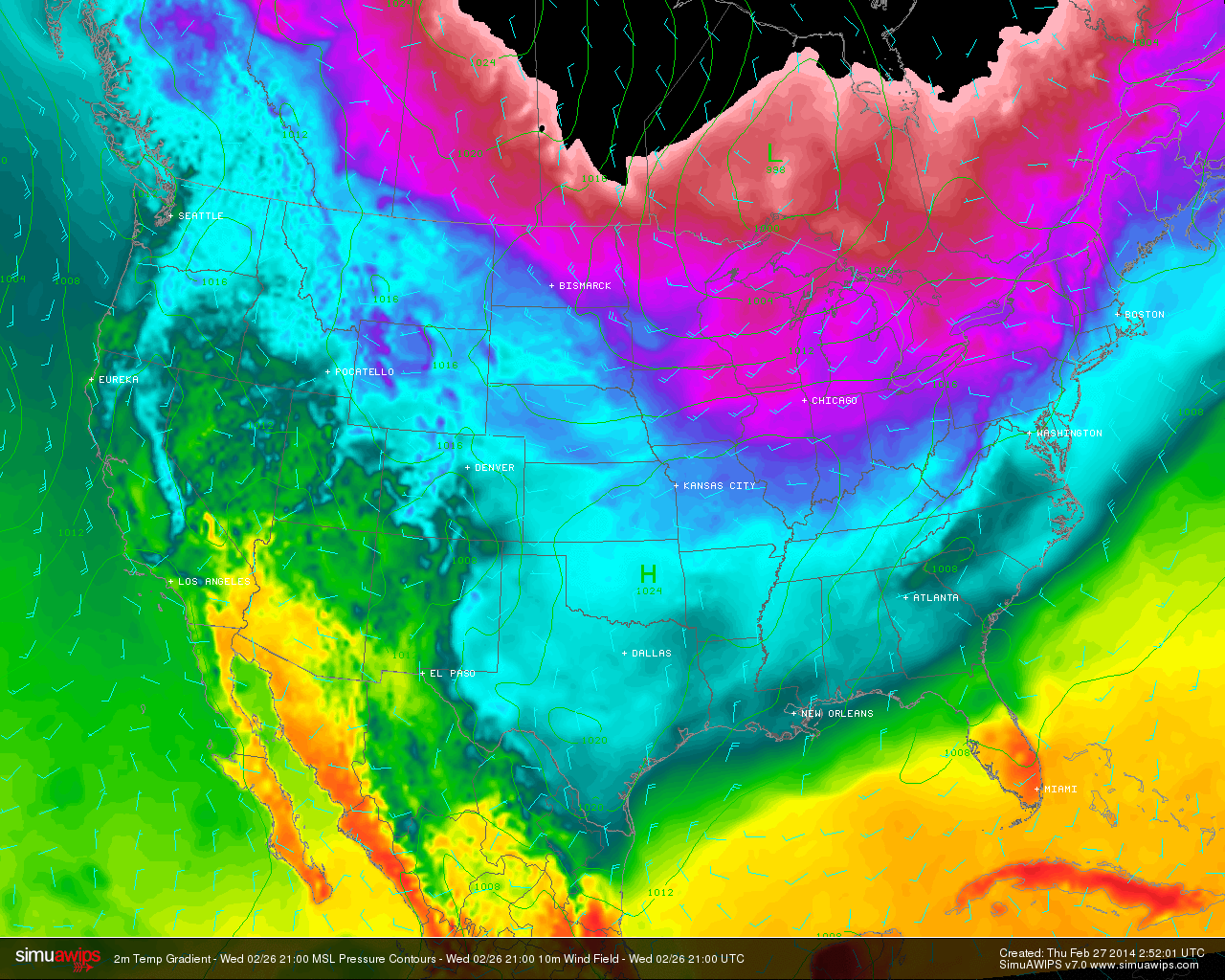
Finally, another arctic cold front will slam into central Indiana tomorrow morning and will be accompanied by howling northerly winds gusting to 40-50 MPH and a potential quick-hitting snow shower.  This will set the stage for a brutal Thursday as temperatures struggle to recover to the lower to middle teens for IND and even colder for the northern ‘burbs.  This is hard to handle when considering we’re expected to “normally” reach the middle 40s this time of year.

simuawips-2

Permanent link to this article: https://indywx.com/word-on-the-weekend-and-a-couple-other-items-of-interest/

Looking Ahead; Cold Pattern Reloads.

We’ll have your updated 7-Day forecast posted later today.

The latest mid and long range guidance continues to suggest we’re heading into another prolonged period of below normal temperatures.

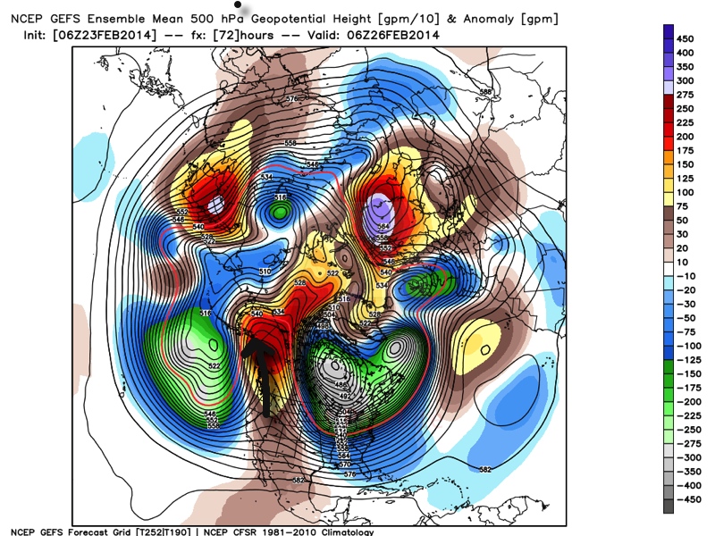
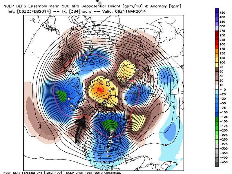
Ensemble data (below) shows ridging in the northeast Pacific, extending into Alaska and this pattern has been one of the big reasons as to why we’ve dealt with so many arctic intrusions this winter.  (The first image is a look at the upper air pattern dated Feb. 26th and the second is dated March 11th).

Ridging in this particular part of the globe often times dislodges the cold air and someone “down stream” has to deal with below normal air.  The recipient of being “down stream” has just so happened to be the upper Mid West into the Ohio Valley and much of the eastern half of the country this winter.  That doesn’t show any signs of changing over the next couple weeks, at least.  It’s possible we could deal with a day or two of milder weather thrown in the mix, but the overwhelming majority of the upcoming couple weeks looks much colder than normal.

GEFS1GEFS2

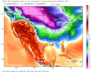
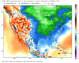
The result is a continuation of much below normal cold in our part of the country.  The following graphics illustrate temperature anomalies (in celsius) centered on 5 days between Feb. 23rd-28th and March 6th-11th.  Below normal temperatures continue.

GEFS3GEFS4


A couple of additional thoughts around the upcoming cold pattern: While we can’t show the images here (license issues), the “secret” European weeklies and ensemble data continues the cold, stormy regime across the east for the better part of the upcoming 30 days, with a couple of brief periods of milder, “calmer” weather.

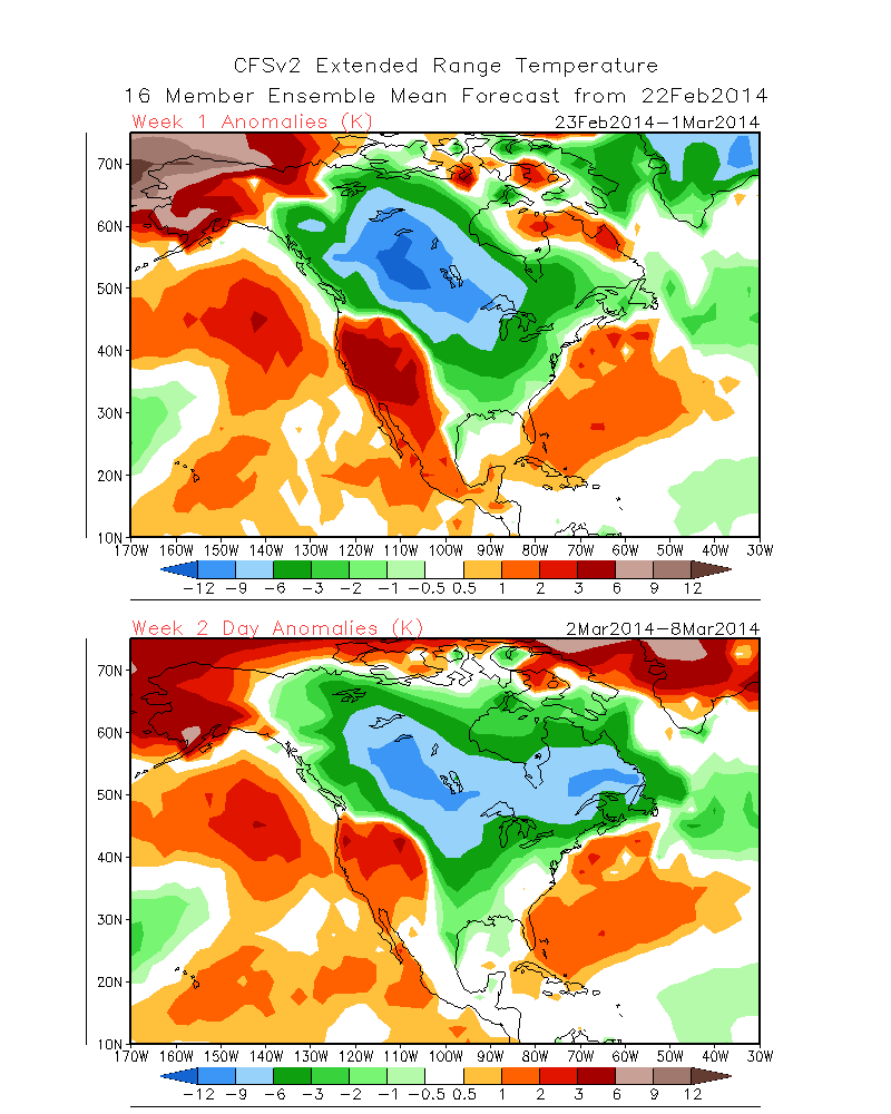
Finally, the CFSv2 suggests the cold regime continues, as well.  The first image shows upcoming weeks 1 and 2 and the second shows temperature anomalies weeks 3 and 4.  Note the CFSv2 shows southeast ridging developing towards the end of the period, potentially suggesting a big fight goes on between the cold to the north and the budding spring conditions to the south- a stormy suggestion…

CFSv2Wk1:2CFSv2Wk3:4

In closing, it’s important to note that all of the fancy graphics shown above are simply model guidance and it’s up to us, the forecasters, to interpret the data the best way possible to put together the most accurate mid to long range ideas for you, the viewer.  While nothing is a guarantee in this business, it does appear as if chances are quite high that our region deals with another few weeks of colder than normal conditions and potentially active weather ahead.  Stay tuned.

Permanent link to this article: https://indywx.com/looking-ahead-cold-pattern-reloads/

Sunday Afternoon Thoughts…

1.) A scan over the latest data continues to point towards an absolute mess of a Monday afternoon.  Our accumulation ideas remain relatively unchanged from this morning’s update, aside from “beefing” expected snow totals for Indy’s northern ‘burbs by 1″.  Most of this falls from noon to 6pm and will be followed by a dry, cold, and blustery Monday night.  After likely a white-nuckle evening commute Monday, the combination of sub-freezing temperatures and gusty northwest winds Monday night will likely lead to another rough commute for Tuesday morning.

** We caution that this will be another “now cast” situation when it comes to precipitation types and their respected precise zones tomorrow afternoon.  Stay tuned here or to your favorite local weather media for updates and potential changes.**

  • Indianapolis northern ‘burbs, including Zionsville: 2-4″ snow and sleet with less than 0.10 of freezing rain.
  • Indianapolis proper: 2″ snow and sleet with around 0.10 of freezing rain
  • Indianapolis southern ‘burbs, including Greenwood: 1″ snow and sleet with up to 0.25 freezing rain.

Snow:IceForecast021714

2.) We continue to monitor what will be a brief thaw and associated flood risk mid week.  Even without rain, water rise would occur and urban flooding from the combination of melting snow and blocked (from all of the snow) drainage zones.  When you add 0.50-1″ of rain atop the melting then problems could arise Wednesday into Thursday.  Additionally, we’ll need to prepare for the likelihood of dense fog Wednesday as milder air surges north over a deep snow pack.

3.) For anyone thinking spring is setting in during our mid week thaw will need to think again. Latest model data continues to suggest we reverse things quickly later this week and for the upcoming weekend.  In fact, some model data, including the European, suggests central Indiana is under the gun for a weekend winter storm.  We’ll continue to monitor closely…

021614ECSatWinterStorm022214

4.)  Additionally, prospects continue to grow for another extended period of well below normal cold and renewed wintry precipitation chances in the long term (into March).  Both the GFS and European models are in agreement on the mid to long range pattern with a trough settling back into the eastern half of the country.

02161412zGFSEC

Permanent link to this article: https://indywx.com/sunday-afternoon-thoughts/