Category: Unseasonably Cool Weather

Accumulating Snow Potential Wednesday Evening; Model Madness This Weekend…

Models are handling the arctic front and associated wave differently from one another, but we tend to favor more of a GEM/ European blend.  As it is, even the GFS is beginning to see the snow threat.  The NAM (below) sees snow overspreading the region Wednesday afternoon and evening.

hires_ref_indy_55This is a different set-up than anything we’ve seen this winter as the majority of precipitation develops on the backside of the frontal boundary.  An “ana front” is one that features clouds and precipitation developing behind the frontal system.  The air behind this boundary will be of arctic origin and lead to very high snow ratios- meaning it won’t take much moisture to “fluff” up a few inches of snow across the region.  Strong and gusty winds will also develop Wednesday night and temperatures will plummet (single digits or below zero Thursday morning).  Blowing and drifting will be a concern.  Stay tuned as we continue to look over the data.

The other item on the agenda has to do with Sunday.  Once again we’ve got another major model battle on our hands.  Taken verbatim, the GFS would imply a relatively boring weather weekend with some clouds and light rain (possibly ending as light snow Saturday night into Sunday).  On the other hand, the European model implies a winter storm threat for the Ohio Valley Sunday….

Needless to say, there’s a lot going on and despite the headaches of last weekend, we may be back in a similar position for the upcoming weekend.  And you thought you wanted this job?! 🙂

Permanent link to this article: https://indywx.com/accumulating-snow-potential-wednesday-evening-model-madness-this-weekend/

Cold Start To The Work Week; Watching Wednesday…

Screen Shot 2015-02-02 at 7.46.45 AMBundle Up…Snow showers and gusty winds are combining with refreezing of snow and moisture on roadways to create slick travel this Monday morning.  Leave extra time on your way to work and school this morning and travel safely.  Additionally, gusty northwest winds are pushing wind chill values into the subzero ranks.  As we progress through the day we should see increasing sunshine, but it’ll remain frigid.

Our next storm system of interest arrives by the middle of the week.  Forecast models differ on the timing and amount of moisture with this next storm, but there’s the chance of accumulating snow arriving Wednesday.  This would be in advance of a quick-hitting pop of arctic air.  We’ll keep a close eye on things.

The active pattern remains into the upcoming weekend as increasing clouds give way to showers Saturday and a transition to more a of wintry mix Sunday.

Upcoming 7-Day Precipitation Forecast:

  • 7-Day Snowfall Forecast: 1″ – 2″
  • 7-Day Rainfall Forecast: 0.10″ – 0.20″

Permanent link to this article: https://indywx.com/cold-start-to-the-work-week-watching-wednesday/

Period Of Snow Moving In…

As mentioned below, bust potential was/ is high with today’s forecast.  The further north trends in the NAM and GFS will ultimately trump the normally reliable Canadian and European solutions.  As such, slushy snowfall accumulations will be light (1″-2″) for the city, itself, increasing to between 2″-5″ for northern Indianapolis suburbs (Zionsville, Carmel, Westfield, Noblesville, etc.).  Double digit totals will fall across the northern third of the state.

For the most part, snowfall accumulations will come from this area of precipitation moving through the region.

Screen Shot 2015-02-01 at 9.30.06 AM


Heavy wet snow will likely fall for a period of time, especially from northern portions of Indianapolis and points north late morning into the early afternoon.

hires_ref_indy_6


Temperatures will then likely creep up a few degrees through the mid afternoon hours before falling this evening.  Snow will mix with, or change to, snow across central regions this afternoon with the northward track of the low.  Note the stark temperature contrast across the region this evening.

hrrr_t2m_indy_16


The week will get off to a cold start as highs Monday only top out in the lower 20s.  Enjoy your Super Bowl Sunday and keep the reports coming!

Permanent link to this article: https://indywx.com/period-of-snow-moving-in/

Weekend Snow Storm…

Screen Shot 2015-01-30 at 7.10.35 AM
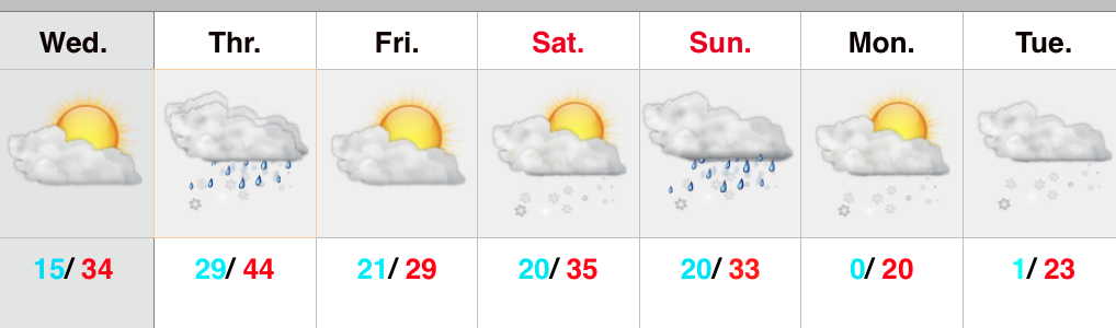
Weekend Snow Storm On Deck…Scattered snow flurries and snow showers will come to an end this morning with increasing sunshine following.  Despite seeing a little vitamin D this afternoon, it won’t do anything to help us in the temperature department.  In fact, we already experienced our high around midnight.  Temperatures this afternoon will remain in the middle to upper 20s with a gusty wind.

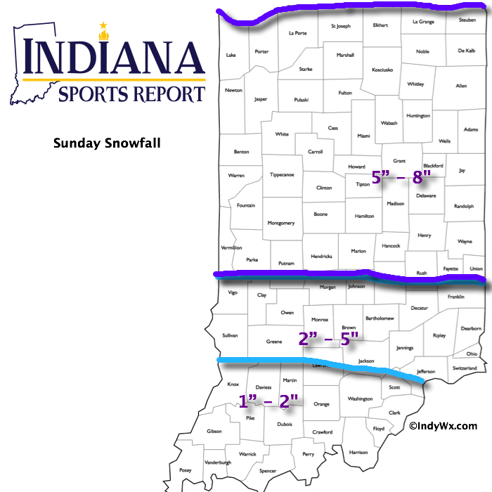
Most of Saturday will be quiet (calm before the storm) with dry conditions and afternoon highs around 40.  Clouds will lower and thicken as we go through the afternoon and evening and snow will develop (rain or a wintry mix down state initially) across central Indiana during the overnight.  Snow will increase in intensity Sunday morning and grow heavy at times during the day as low pressure tracks along the Ohio River (a classic track for central Indiana snow storms).  See our initial accumulation map below, which is still subject to change.  We’ll introduce a gusty east and northeast wind into the mix Sunday evening and night and this will lead to blowing and drifting snow Sunday night.  Stay tuned.

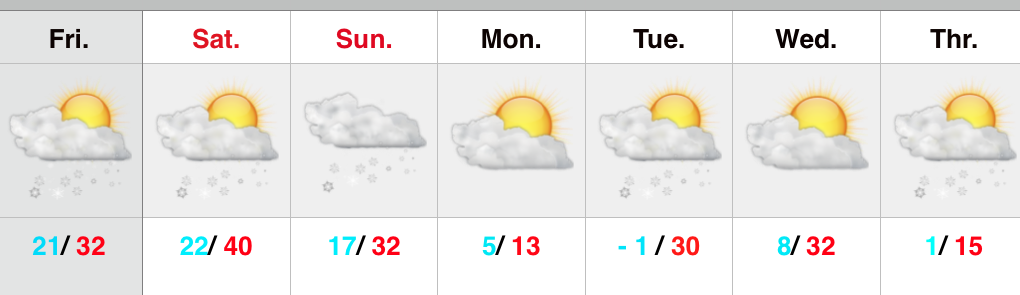
The big story next week will be the cold, but we’re also watching two potential snow makers, as well.  More on that after we deal with Sunday’s snow storm.

Upcoming 7-Day Precipitation Forecast:

  • 7-Day Snowfall Forecast: 5″ – 10″
  • 7-Day Rainfall Forecast: Trace

2115SnowfallMap

Permanent link to this article: https://indywx.com/weekend-snow-storm/

Late Night Update: Snow Storm Brewing…

Early forecast model data into the office tonight suggests we remain on track for a disruptive widespread snow storm this weekend. We note the timing is speeding up just a…

You must be logged in to view this content. Click Here to become a member of IndyWX.com for full access.  Already a member of IndyWx.com All-Access?  Log-in here.

Permanent link to this article: https://indywx.com/late-night-update-snow-storm-brewing/