Category: Unseasonably Cool Weather
-
Filed under Autumn, CFSv2, El Niño, European Model, Forecast Discussion, Forecast Models, JAMSTEC, SST Discussion, Summer, T-storms, Unseasonably Cool Weather
-
August 13, 2015
We may only be in mid August, but the IndyWx.com office is busy putting together initial thoughts around fall and winter (it’ll be here before you know it)! The upcoming…
You must be logged in to view this content. Click Here to become a member of IndyWX.com for full access. Already a member of IndyWx.com All-Access? Log-in here.
Permanent link to this article: https://indywx.com/thoughts-shifting-to-fall-and-winter/
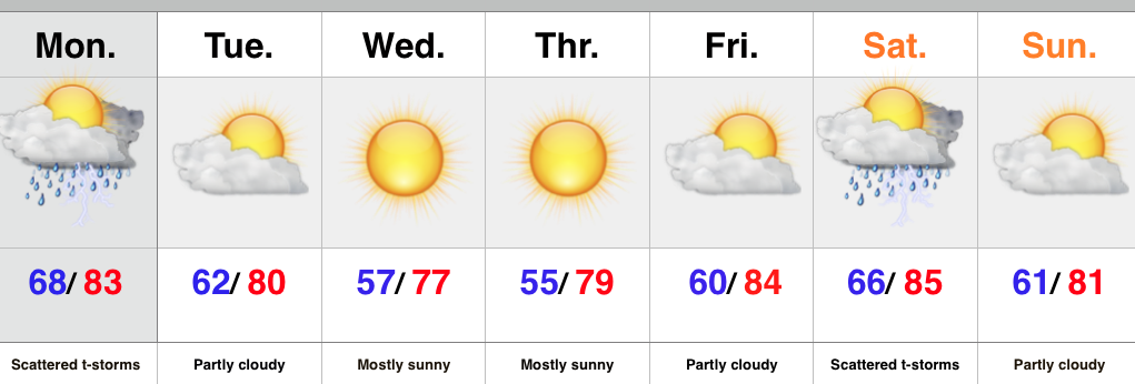
 Highlights:
- AM fog gives way to lots of sunshine
- Early fall preview
- Warmer days return
- Spotty weekend storms possible
We still have warm to hot days left before we get into true fall air, but the next couple days will have many craving the autumnal season ahead. It’s not every year we can say mid August will feature lows in the mid to upper 50s and highs in the 70s, but that’s the case for Wednesday. Despite some patchy dense fog in spots, look for wall-to-wall sunshine today, continuing right through the end of the work week. Have an extra vacation day or two to use at work? Might we suggest burning them over the next 48-72 hours? 
Warmth and humidity will return heading into the weekend and on into early next week. Additionally, we’ll have to keep a close eye on weak upper level disturbances moving into the region. They may provide just enough “umph” to spark isolated storms over the weekend. Better coverage of thunderstorms can be expected early next week.
Upcoming 7-Day Rainfall Forecast: 0.25″ – 0.50″
Permanent link to this article: https://indywx.com/early-fall-preview/
The morning has dawned with patchy dense fog in spots. Be careful traveling to work and school this morning. Most of today will be dry, but an isolated shower/ sprinkles…
You must be logged in to view this content. Click Here to become a member of IndyWX.com for full access. Already a member of IndyWx.com All-Access? Log-in here.
Permanent link to this article: https://indywx.com/dry-push-of-air-arrives-tonight/
 Highlights:
- Early week storm threat
- Drier, cooler air inbound
- Next rain chance comes Saturday
The week will open with a typical humid and oppressive feel, but take heart in knowing it won’t last long. A cold front will move through the region Monday night and drier air will filter into the Hoosier state Tuesday. A much cooler and drier air mass will be with us through mid week before warmth builds heading into the weekend. Thursday morning will have many really craving those cool, crisp autumn mornings.
As far as rain and storm chances are concerned, we’ll keep an eye to the sky for scattered shower and thunderstorm coverage today. Forecast models differ on the weekend. The GFS suggests a cold front moves through here Saturday with scattered showers and thunderstorms and we’ll lean in that direction for now. Stay tuned.
Upcoming 7-Day Rainfall Forecast: 0.50″ – 0.75″
Interested in winter weather and snow removal consulting? Email us at bill@indywx.com
Permanent link to this article: https://indywx.com/humid-feel-to-open-the-week-doesnt-last/
1. August has gotten off to a cool start through the first eight days and we expect this to continue during the upcoming week, only growing cooler, relative to the…
You must be logged in to view this content. Click Here to become a member of IndyWX.com for full access. Already a member of IndyWx.com All-Access? Log-in here.
Permanent link to this article: https://indywx.com/sunday-morning-weather-rambles-2/
