Category: Unseasonably Cool Weather
The morning has dawned with patchy dense fog in spots. Be careful traveling to work and school this morning. Most of today will be dry, but an isolated shower/ sprinkles…
You must be logged in to view this content. Click Here to become a member of IndyWX.com for full access. Already a member of IndyWx.com All-Access? Log-in here.
Permanent link to this article: https://indywx.com/dry-push-of-air-arrives-tonight/
 Highlights:
- Early week storm threat
- Drier, cooler air inbound
- Next rain chance comes Saturday
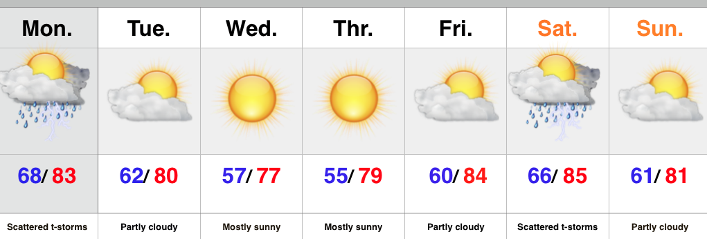
The week will open with a typical humid and oppressive feel, but take heart in knowing it won’t last long. A cold front will move through the region Monday night and drier air will filter into the Hoosier state Tuesday. A much cooler and drier air mass will be with us through mid week before warmth builds heading into the weekend. Thursday morning will have many really craving those cool, crisp autumn mornings.
As far as rain and storm chances are concerned, we’ll keep an eye to the sky for scattered shower and thunderstorm coverage today. Forecast models differ on the weekend. The GFS suggests a cold front moves through here Saturday with scattered showers and thunderstorms and we’ll lean in that direction for now. Stay tuned.
Upcoming 7-Day Rainfall Forecast: 0.50″ – 0.75″
Interested in winter weather and snow removal consulting? Email us at bill@indywx.com
Permanent link to this article: https://indywx.com/humid-feel-to-open-the-week-doesnt-last/
1. August has gotten off to a cool start through the first eight days and we expect this to continue during the upcoming week, only growing cooler, relative to the…
You must be logged in to view this content. Click Here to become a member of IndyWX.com for full access. Already a member of IndyWx.com All-Access? Log-in here.
Permanent link to this article: https://indywx.com/sunday-morning-weather-rambles-2/
 Highlights:
- Half-n-half weekend
- Early week storms
- Fall preview coming
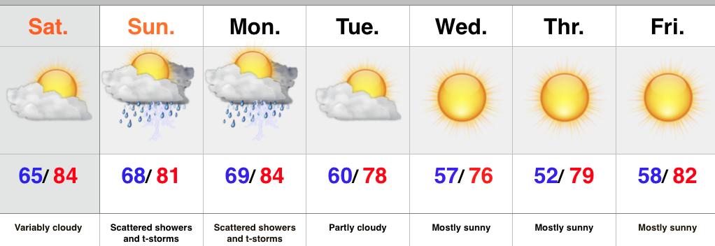
The weekend is off to a pleasant start- both from a temperature and humidity perspective, but also with current sky conditions across the area. Expect periods of mid and high level cloudiness to increase later today. We also note some of our shorter term modeling trying to push light rain into the picture by evening, but think the air mass will take some time to moisten up before we see much in the way of rain. Most of this should dissipate moving into western IN this evening.
The second half of the weekend will provide much better chances of showers and embedded thunder. In fact, we expect a couple waves of showers and thunderstorms Sunday. It won’t rain the entire time, but keep the umbrella and rain gear handy. Thunderstorm chances will continue as we open the new work week before a big push of cooler and drier air engulfs the region heading into mid week. An early fall preview will settle in Tuesday evening and have things feeling mighty nice around these parts for the rest of the week.
Upcoming 7-Day Rainfall Forecast: 0.50″ – 1.00″
Permanent link to this article: https://indywx.com/pick-of-the-weekend-is-today-taste-of-early-fall-coming/
Thursday’s rain is now long gone. Heaviest rains fell south as expected. (Numbers below are only through 24 hours ago). Many reporting sites across central Indiana are returning numbers…
You must be logged in to view this content. Click Here to become a member of IndyWX.com for full access. Already a member of IndyWx.com All-Access? Log-in here.
Permanent link to this article: https://indywx.com/awesome-close-to-the-work-week-weekend-thoughts/


