VIDEO: Sunday Morning Showers Give Way To Afternoon Sunshine…
You must be logged in to view this content. Click Here to become a member of IndyWX.com for full access. Already a member of IndyWx.com All-Access? Log-in here.
You must be logged in to view this content. Click Here to become a member of IndyWX.com for full access. Already a member of IndyWx.com All-Access? Log-in here.
 Highlights:
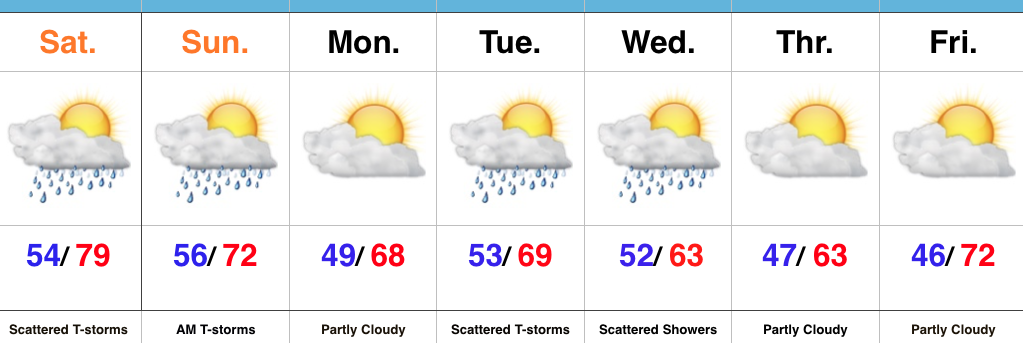
Watching For Afternoon And Evening Storms…We’re starting the day with low clouds, fog, and a chilly easterly breeze. That said, a warm front will begin to lift north this afternoon, allowing a warmer and increasingly muggy feel to return. Scattered thunderstorms will also increase in overall coverage later this afternoon and evening. While widespread heavy rains aren’t anticipated, localized heavy downpours are possible in slower moving, stronger storms.
Scattered showers and thunderstorms will remain Sunday morning, but a cold front will pass around lunchtime with drier air arriving by the afternoon hours. If you have plans outdoors Sunday, the afternoon and evening looks absolutely beautiful with a more pleasant air mass building in with those drier conditions.
Unsettled conditions return Tuesday into Wednesday with unseasonably cool air. As of now, the early outlook for the big race weekend and Memorial Day holiday is a dry one, with just a scattered shower chance Saturday. Stay tuned.
Upcoming 7-Day Precipitation Forecast:
 Highlights:
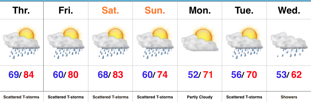
Periods Of Storms In The Days Ahead…While we’ll have more dry time than not into the weekend, multiple rounds of showers and thunderstorms can be expected as we close the work week and move into the weekend. With a moisture-rich air mass in place, locally heavy rain is possible. Storms will reach most widespread coverage during the afternoon and evening hours through Saturday.
A cold front will sweep through the state Sunday with scattered to numerous showers and thunderstorms followed by drier, cooler air for Monday.
As we progress through next week, the region will remain in a much cooler, challenging northwest flow. Individual disturbances will race southeast and result in continued unsettled weather as race weekend and the Memorial Day holiday draws closer. We’ll keep a very close eye on things. The balance of next week will be significantly cooler than average.
Upcoming 7-Day Precipitation Forecast:
You must be logged in to view this content. Click Here to become a member of IndyWX.com for full access. Already a member of IndyWx.com All-Access? Log-in here.
 Highlights:
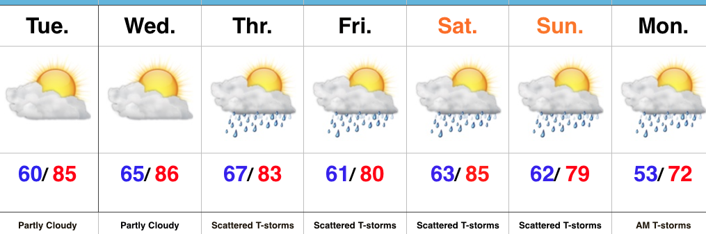
Very Warm And Increasingly Humid…High pressure will supply continued dry conditions, along with unseasonably warm temperatures through midweek. A southwesterly air flow will help push an increasingly muggy feel into the region by Wednesday. “Air you can wear” will be an appropriate way to sum things up! 🙂
That increasing moisture will eventually yield better coverage of showers and thunderstorms as we move through late week into the weekend. It certainly won’t rain the entire time, but periods of scattered thunderstorms will be with us Thursday through Monday morning. With high moisture content, locally heavy rains will be possible.
A cold front will move through the state Sunday night and Monday and result in a significantly cooler trend next week.
Upcoming 7-Day Precipitation Forecast: