Heavy Rain Gives Way To A Gorgeous Weekend…
 Highlights:
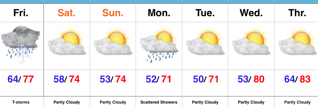
- Heavy rain and storms through the daytime
- Much cooler and drier air on the way
- Pleasant week ahead
Tropical Downpours Today…The remnant tropical moisture of Cindy is lifting northeast this morning while a cold front is dropping south. The combination of these two weather features will result in an expanding area of rain and thunderstorms across central Indiana late morning into the early afternoon. Periods of heavy rain can be expected. Thankfully, this won’t be a long duration event and a much drier air mass will invade from northwest to southeast by evening. We’ll easily notice this drier trend as dew points go from about as high (lower-middle 70s) as we ever see them this morning to a very crisp feel (dew points in the 50s) tonight.
The cooler and drier theme will continue through the weekend into the majority of the upcoming week ahead. As noted in previous discussions, a fast-moving northwest flow will be responsible for sending a couple of minor upper level disturbances southeast into the region. For the most part, we believe scattered showers will remain north of central Indiana until Monday afternoon and evening. While this won’t be a significant event by any stretch of the imagination, a couple of showers are possible.
Our air flow will eventually shift around to the southwest by the middle of the week and this will begin to send a warmer and increasingly moist air mass north by Thursday.
Upcoming 7-Day Precipitation Forecast:
- Snowfall: 0.00″
- Rainfall: 1.50″ – 2.00″ (locally heavier amounts)
 Highlights:
 Highlights: