We don’t see any reason to alter our thinking of how the upcoming (4) weeks plays out:
This week features a transitional pattern back to a predominantly colder and snowier than average period from 2/18 through 3/10.
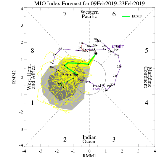
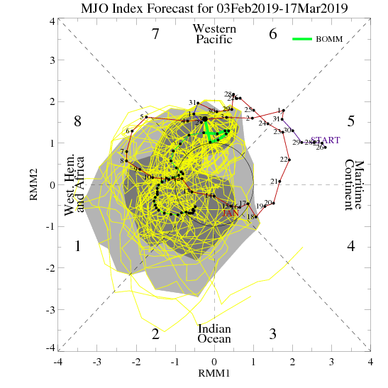
The MJO continues to have Phase 8 on its mind.
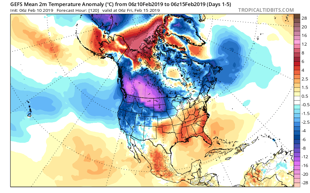
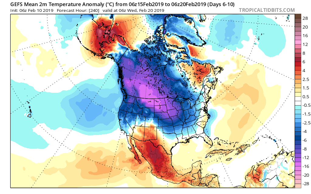
To no surprise, the GEFS is going right to what a Phase 8 should yield:
Days 1-5
Days 6-10
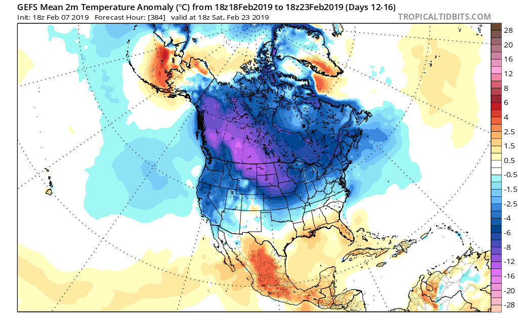
Days 10-14
With widespread cold set to once again overwhelm the pattern, the active storm track will begin to take on an increasingly snowy theme in the aforementioned period. This is a type pattern that may once again challenge cold records somewhere in the late February or early March time frame. While likely not to the magnitude of the bitter blast a couple weeks ago, it wouldn’t surprise us in the least to head back to record daily cold territory before pulling out of this pattern and heading on towards spring.
You must be logged in to view this content. Click Here to become a member of IndyWX.com for full access. Already a member of IndyWx.com All-Access? Log-in here.
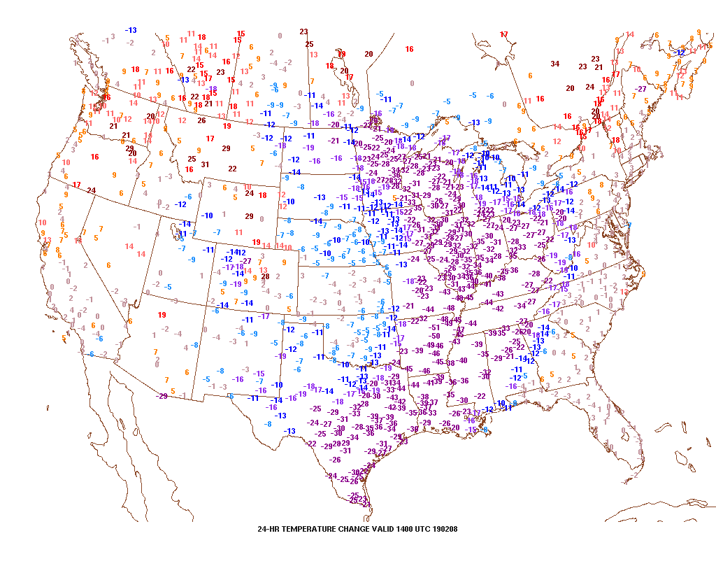
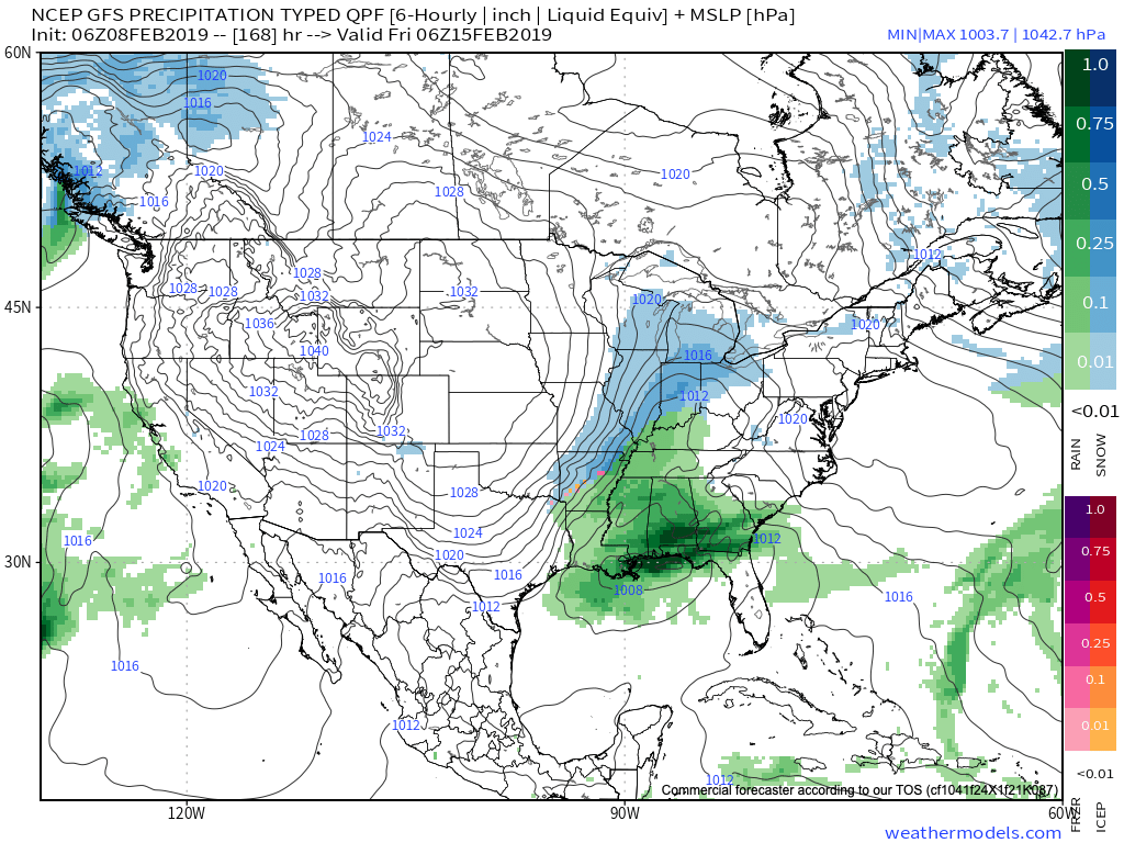
It’s feeling just a little bit different across the region this morning- to the tune of more than 30 degrees colder than this time 24 hours ago. Cold extends south all the way to Brownsville Texas. Speaking of Texas, wintry precipitation is flying across the Hill Country this morning…
Back here on the home front, cold is the story this weekend. Highs may creep into the lower 20s this afternoon, but wind chill values will remain in the single digits below zero to 5 above through the day. Light snow showers will end and we’ll introduce more in the way of sunshine through the afternoon.
Dry conditions will remain through Sunday morning, but a storm system will organize to our southwest, eventually delivering moisture into central Indiana Sunday afternoon into the evening. We remain unimpressed with this feature, but light snow is a good bet during this timeframe. Early thinking would deliver between a coating to an inch and there’s also the potential of a light “glaze” atop the snow Sunday night as milder air aloft begins to win out.
“Dueling” low pressure systems will lead to continued unsettled conditions through Tuesday. The initial low will track into the Great Lakes while a secondary area of low pressure forms along the Mid-Atlantic coast. The end result will be a briefly milder time of things and periods of rain Monday afternoon and Tuesday (0.50″ to 1″ amounts) before cold air whips back in here Wednesday.
Lingering left over moisture will fall as scattered snow showers in the sharply colder air Wednesday.
Our next storm system will deserve a watchful eye in the Thursday-Friday time frame, but it’s far too early for specifics in this hectic pattern.
The active pattern is set to remain, along with progressively colder air as we rumble into the 2nd half of February. Above normal precipitation is anticipated, including above normal snowfall in the 2/18 through 3/10 period.
The stage is set for winter’s return. With that said, the upcoming week will likely feature a “transitional” time of things before winter returns with more authority during the 2/18 through 3/10 time period.
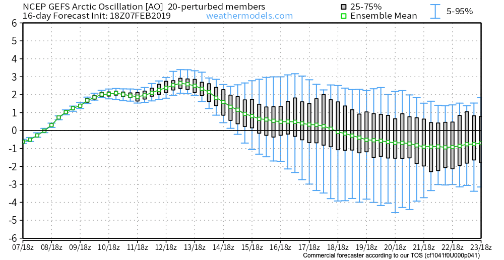
While the positive AO will continue to be heard from in the more immediate term (forcing the active storm track into the Ohio Valley and Great Lakes), this should eventually give way to a negative AO by mid and late month. Factor in a Phase 8 of the MJO and developing negative NAO and winter weather lovers will likely have a 2-3 week period of “fun and games,” including the potential of a couple significant events, along with well below normal cold late February and early March.
That said, this isn’t last year. Recall it was around this time that we were initially “faked out” by a wintry February when in all actuality it was a case of delayed, but not denied, with the worst of winter (relative to average, and in the means from a snow perspective) occurring in March and April. There are growing indications that we should actually have a spring this year, but more on that at a later time. 🙂
Let’s take a look at some of the latest long range modeling, starting with teleconnections first (always the basis of a long range forecast).
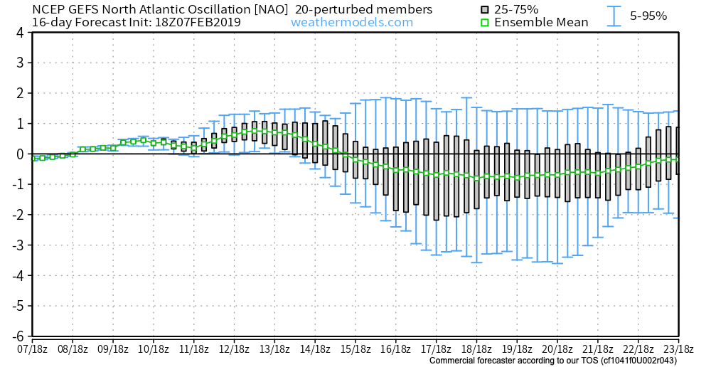
Simply put, the GEFS teleconnections line up for a return of colder than normal conditions during the middle to latter part of February. We love to see the agreement in the teleconnection states (trending negative AO (image 1) and NAO (image 3) and trending positive PNA (image 2)).
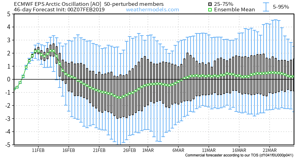
The latest European Weeklies would also agree. Note the strongly positive AO (image 1 below) at present dips negative during the 2nd half of February.
The European Weeklies like the idea of the PNA at least getting to neutral late month into early March.
Also of importance is what the Weeklies do with both teleconnections by mid-March (this would support a warmer pattern, overall).
Since we’re talking about the European Weeklies, while we can’t show the model output itself, it should be noted the model does deliver cold back into the region in rather widespread fashion during the last couple of weeks of February and into the first week of March.
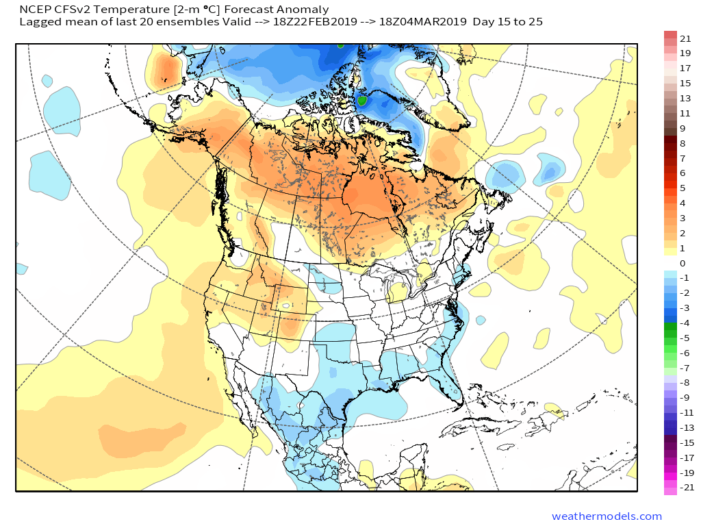
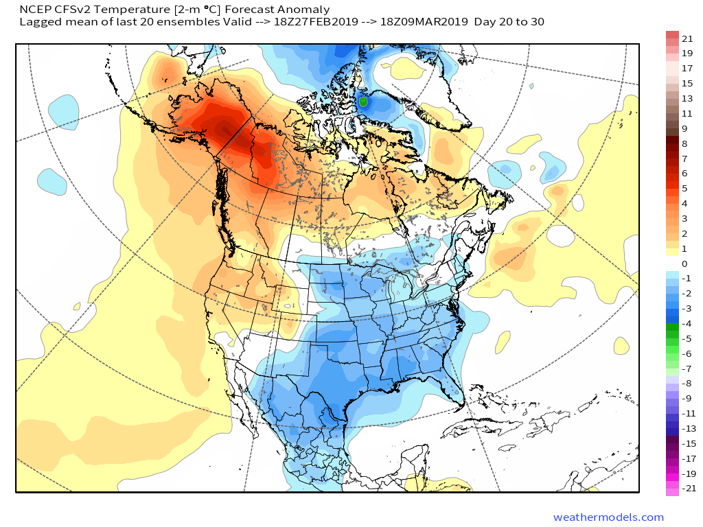
Other model data paints a similar picture as noted below between the GEFS and CFSv2 Weeklies:
Days5–15
Days 15-25
Days 20-30
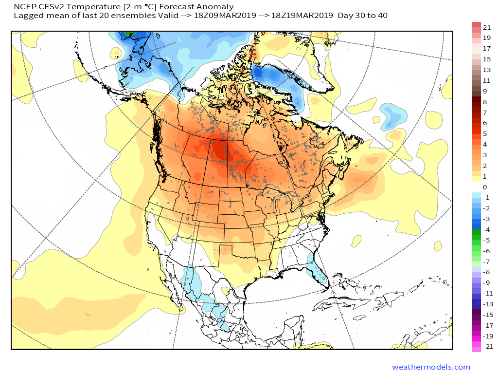
But, like other data would suggest, the CFSv2 is also in agreement that as early March gives way to the middle of the month, warmer times loom…
Days 30-40
(In the event you missed it this morning, we reviewed the updated JMA Weeklies earlier here).
The latest MJO update continues to back up the idea of colder times returning mid and late February, continuing into early March, as noted below. Remember, this time of year, Phases 8 and 1 are colder phases for our neck of the woods.
To summarize, we expect this upcoming week to begin the transition back towards an overall colder and increasingly busy time of things from a wintry perspective. Those will snow removal interests should anticipate above average snowfall during the 2/18 through 3/10 time frame. The aforementioned period also should run colder than average, as well. However, those tired of winter, hang in there- hope is on the horizon once to mid-March and we should actually enjoy a pleasant spring this year after missing out in ’18!
You must be logged in to view this content. Click Here to become a member of IndyWX.com for full access. Already a member of IndyWx.com All-Access? Log-in here.