You must be logged in to view this content. Click Here to become a member of IndyWX.com for full access. Already a member of IndyWx.com All-Access? Log-in here.
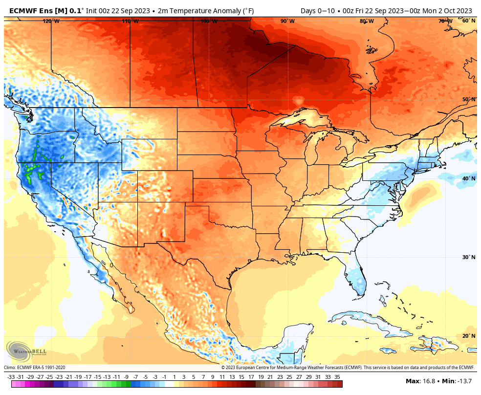
The pattern over the next 10 days will continue the same warmer than normal theme we’ve grown accustomed to as of late. Keep in mind that “normals” have now fallen into the lower to middle 70s for highs and lower 50s at night. Certainly far from a “blow torch,” but temperatures will run 5° to 10° above the norm as we put a bow on September.
Short-term rain chances will be handled in our daily videos. Guidance continues to differ widely on our mid week system. Needless to say, we’re not overly optimistic on the wetter solutions as of now, but will closely monitor to see if more consistency develops down the road.
As a whole, the pattern continues to look drier than normal over the next couple weeks overall.
Week 1
Week 2
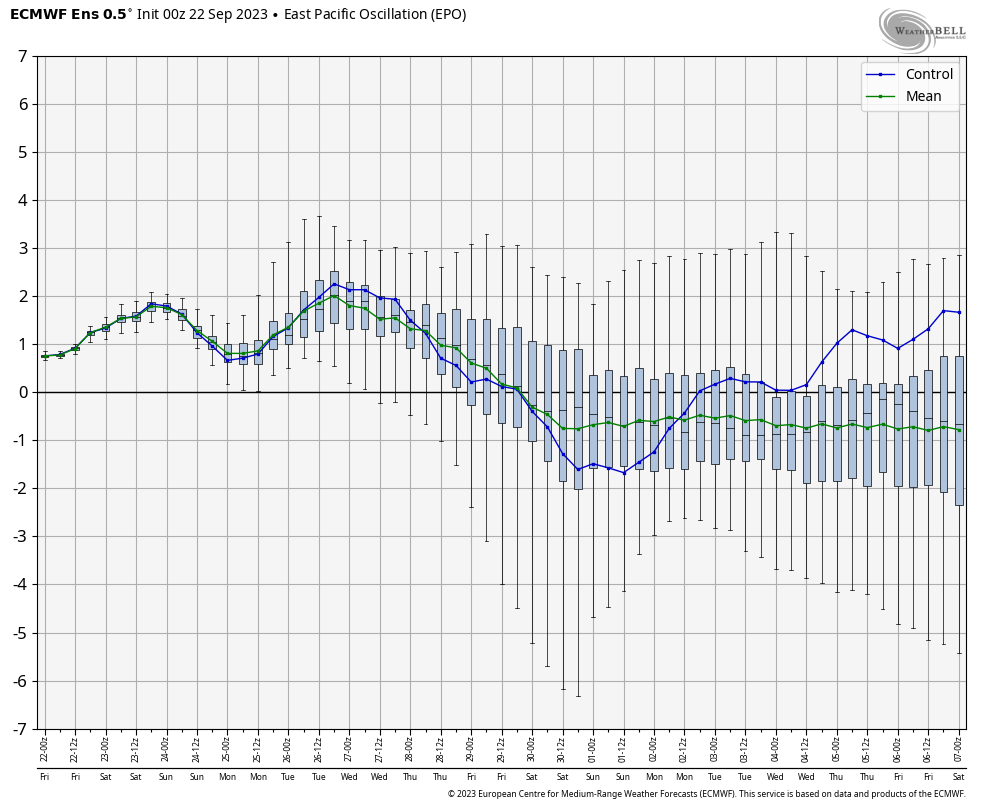
While guidance continues to look warm into early and mid October, I have to raise an eyebrow based on the latest teleconnection trends. We note the EPO trending negative while the PNA pops positive. These drivers should force a colder look Week 2 into Week 3 and I would suspect guidance will cool significantly as we get closer.
Further down the road, it’ll be important to keep tabs on western Pacific typhoon activity and the Madden Julian Oscillation. There are signs we may finally start to see the MJO become more of a player in the pattern towards mid October. Time will tell.
In the meantime, keep a close eye on guidance Week 2 into Week 3 as this will be the first real test case to revisit so far this meteorological fall season…
The pattern transition from the current cooler than normal regime to a warm September finish, compared to the norm, will get started the middle of next week. We still have several days to go with highs of 82°+ to close out the month. The pattern, as a whole, looks drier than normal. The exception to that general rule will come Sunday with scattered showers (the system that generates Sunday showers here will serve to ignite an early season ‘Nor Easter early week for the Mid Atlantic and New England. – A sign of the changing seasons) and we’re still tracking the threat of a more organized storm system in the early Week 2 period. The trend, however, has been for this being less of a player in our weather compared to a few days ago but we’ll continue to keep a close eye on things.
The pattern will transition warmer than normal for the 2nd half of the month.
As we flip the page into October, the pattern drivers from this distance appear to be lining up to drive a period of cooler air as we rumble through the first 1/3 of the month. The Madden-Julian Oscillation (MJO) looks to push into Phase 6. This typically favors the warmer anomalies across the west and Plains with at least a reflection of a trough across the East Coast.
The Pacific North America pattern (PNA) and East Pacific Oscillation (EPO) are working in tandem to also favor a cooler regime across our portion of the country. It’s fair to say that we believe the longer range warm “look” will be forced to cool over the course of the next couple weeks for early October.
The dry, relatively boring regime should begin to turn more active as we close out the month and move into October. The thinking here is that we should see a resurgent wet regime the deeper into fall we go before rolling into the drier than normal predominant winter pattern.
You must be logged in to view this content. Click Here to become a member of IndyWX.com for full access. Already a member of IndyWx.com All-Access? Log-in here.
You must be logged in to view this content. Click Here to become a member of IndyWX.com for full access. Already a member of IndyWx.com All-Access? Log-in here.