Considerable Cloudiness To Open The Work Week…
 Highlights:
- Mostly cloudy start to the work week
- Another cold front moves in
- Turning cooler late in the weekend
Comfortable Late-Summer Week Ahead…Talk about a bust of a Sunday forecast on our part. Dry air and lack of forcing resulted in steady rains remaining across southern parts of the state. With the exception of a couple of brief showers, central and northern portions of the state remained dry most of the day.
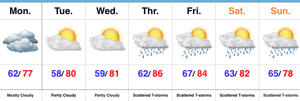
While we’ll remain with mostly cloudy skies today, most of the region will once again remain free of any rain. The exception will be across southeastern Indiana where steady rains have been falling this morning. That will continue to move east into Ohio as we push forward. Otherwise, drier air will arrive tonight and set the stage for increasing sunshine Tuesday and Wednesday. With low humidity and below normal temperatures, both days will be great to spend time outdoors, or perhaps a trip to the Indiana State Fair is in order?
Moisture will begin to return by Thursday and with an approaching cold front, scattered showers and thunderstorms will be with us through the weekend. As of now, most widespread storm coverage is expected late Saturday into Sunday morning. We’ll turn significantly cooler than normal (yet again) early next week.
Tropics: As expected in August into September, the tropics are turning increasingly active. This morning, Tropical Storm Franklin continues to grab headlines as he is becoming more organized and positioned to impact the Yucatan today through Wednesday. From there, Franklin is anticipated to move into the southern Gulf of Mexico Wednesday. With very warm waters and a low shear environment, Franklin should strengthen yet again before making a second landfall late in the work week along the east-central Mexican coast.
Upcoming 7-Day Precipitation Forecast:
- Snowfall: 0.00″
- Rainfall: 0.50″ – 1.00″
 Highlights:
 Highlights: