
 Highlights:
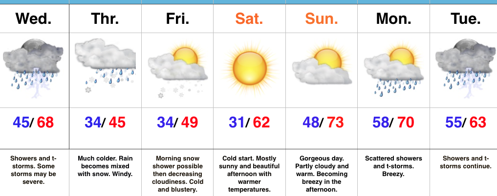
- Stormy Wednesday
- Snow mixes with rain Thursday
- Gorgeous weekend upcoming
- Busy times return next week
Remain Weather-Aware…Chilly, dry weather will continue this evening before showers and thunderstorms (non-severe) approach the western Indiana state line overnight and early Wednesday. Initially, showers and thunderstorms will impact western and northwestern portions of the state before all of central Indiana gets into the act by the afternoon hours. We continue to be concerned for the potential of an active severe weather day across the southern half of the state. All modes of severe weather will be possible, including tornadoes. As of this update (late Tuesday night), the greatest risk area appears to lie within areas from Indianapolis and points south and southeast. We’re most concerned for the period 2p-8p and will fine tune things early Wednesday if needed. Please remain weather-aware and have a means of getting the latest warnings.
We’ll shift gears rather abruptly from severe to more of a wintry feel to close the work week. Much colder air will spill into central Indiana Wednesday night and Thursday and leftover, wraparound, moisture will begin mixing with wet snowflakes Thursday afternoon and evening. Gusty northwest winds and the unseasonably chilly air will result in a downright ugly, raw day.
After early morning snowflakes Friday, drier air will begin to work into the region and result in increasing sunshine Friday afternoon. This will be a prelude to a gorgeous weekend: After a cold start Saturday, expect lots of sunshine and moderating afternoon temperatures. The warming trend continues Sunday as we top the 70° mark.
Our next storm approaches early next week. Clouds increase Sunday night and give way to showers and thunderstorms Monday into Tuesday. Questions come into play in regards to timing with this next cold front, but thinking (as of now) only slowly moves the front along, keeping unsettled weather in our forecast early week before a much cooler, drier period of weather by midweek.
Upcoming 7-Day Precipitation Forecast:
- Snowfall: 0.00″
- Rainfall: 2.00″ – 2.50″
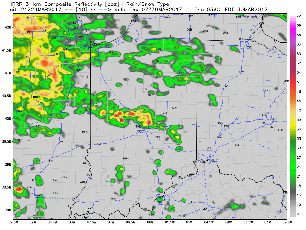 Multiple rounds of showers and thunderstorms will likely impact central Indiana through the mid and late morning hours Thursday.
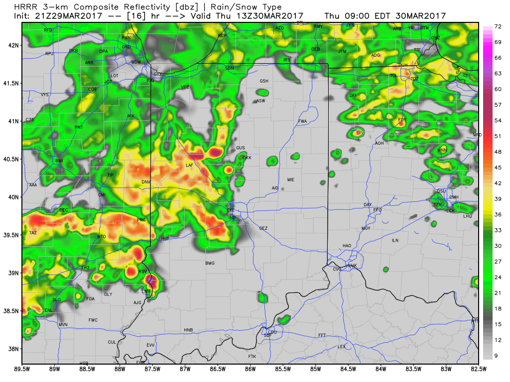 As we press into the early afternoon hours, model data suggests we see a “lull” in the stormy weather and potentially even a few breaks in the cloud cover. This would serve to “up the ante” in regards to the prospects of severe weather potential Thursday afternoon, particularly mid and late afternoon through the evening hours. Accordingly, the Storm Prediction Center continues to highlight central Indiana for the risk of severe weather Thursday.
 In fact, given a look at the most recent data, I wouldn’t be surprised to see the “enhanced” risk area expand further north in future updates. This would also include all modes of severe weather (large hail, damaging straight line winds, and potentially a tornado). As things stand this evening, we bracket the hours of 4p and 10p Thursday for the greatest potential of severe weather.
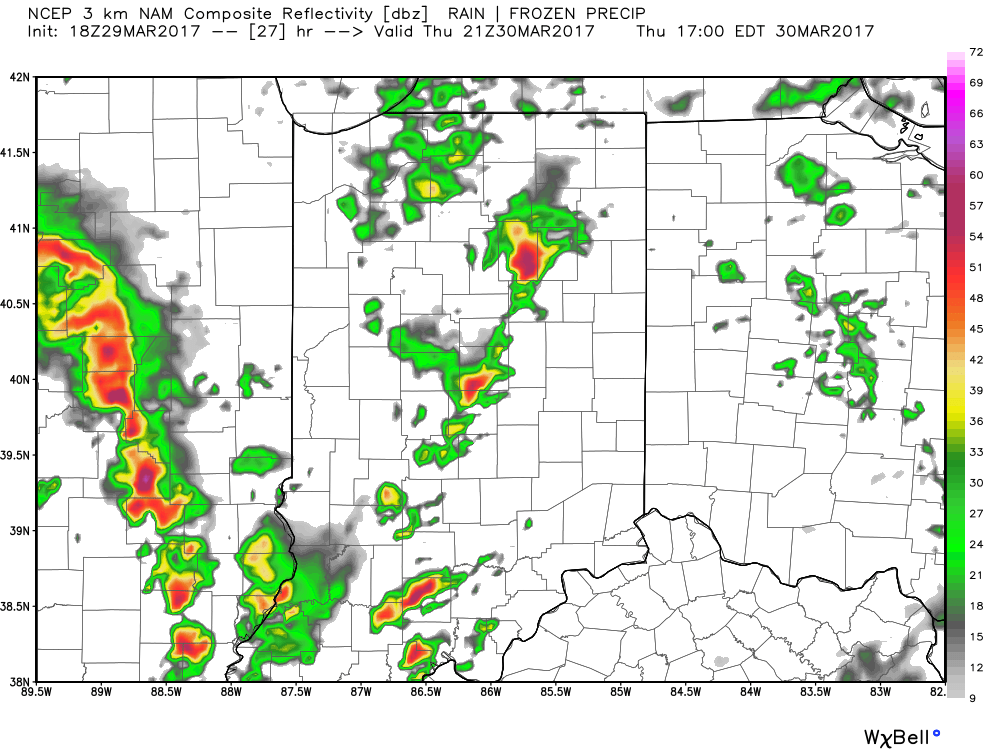 As we push into the overnight hours Thursday into Friday, unsettled weather will continue, but we’ll get rid of the severe potential. “Nuisance” type showers will continue into the first half of Friday before drier air arrives Friday afternoon and evening. This drier theme will settle in for the weekend and provide a very pleasant open to April.
 This warmer regime is the sign of stormy times that will develop as we move into Tuesday. An initial round of showers and thunderstorms will impact central Indiana Tuesday morning and the HRRR forecast radar is picking up on this nicely, especially during the predawn hours.
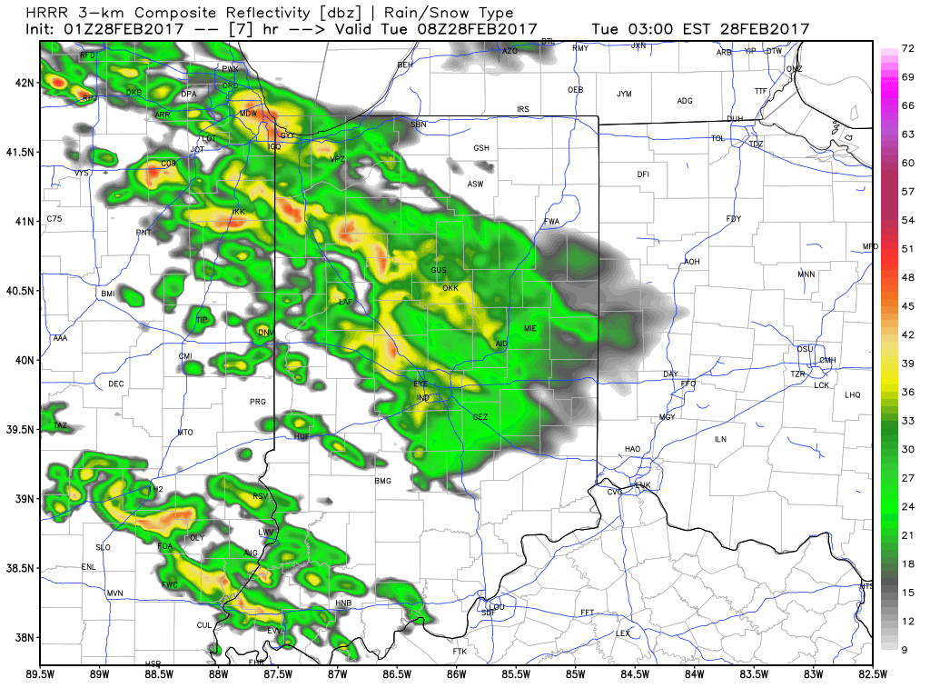 The wet, stormy start to the day will give way to a mostly dry time of things through the majority of the daylight hours Tuesday, but our concentration will be on the Tuesday night-Wednesday morning period, as the potential exists for some rather turbulent weather.
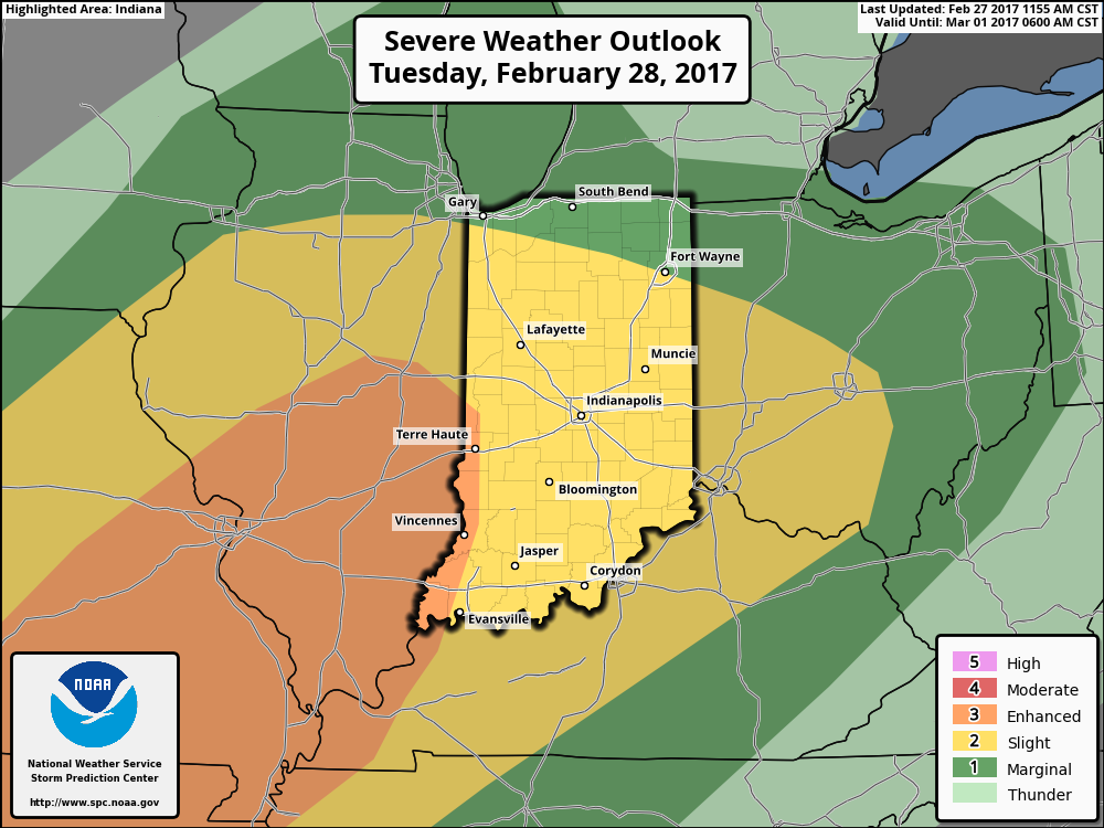 Modeled radar suggests things may begin to get “busy” around these parts late evening and during the overnight. The latest high resolution NAM (hot off the press as of this update) paints a rather ominous look as midnight nears Wednesday morning.
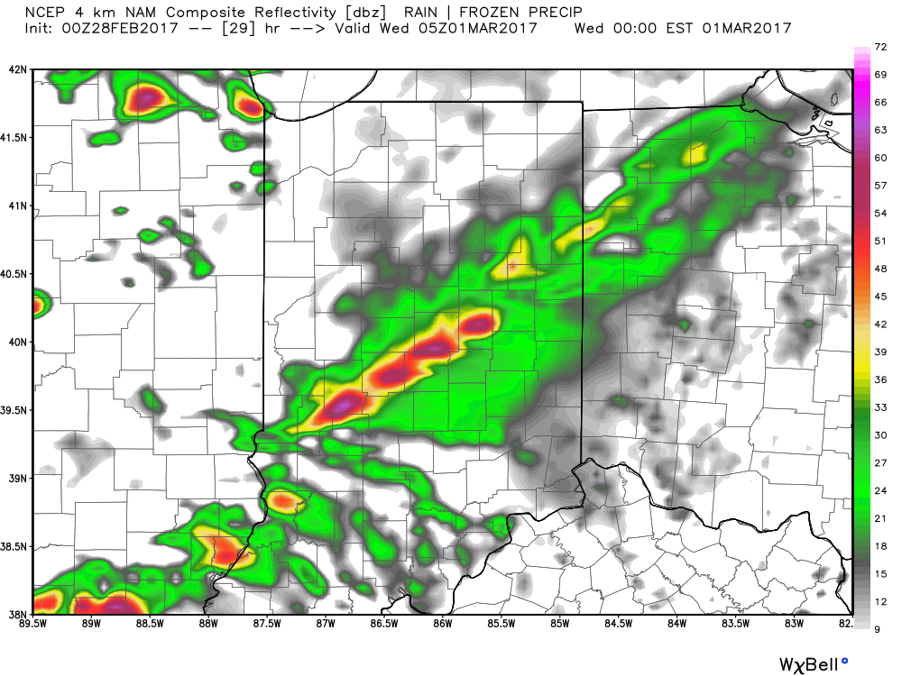 We then note modeling bringing the squall line through central Indiana during the overnight and predawn hours. We’ll have to fine tune timing as we move through the day Tuesday, but we bracket the hours of 2a and 6a when a concentrated line of strong to severe storms rumbles through the state (northwest to southeast). Hail and damaging straight line winds are of greatest concern, but a quick spin-up tornado can’t be ruled out.
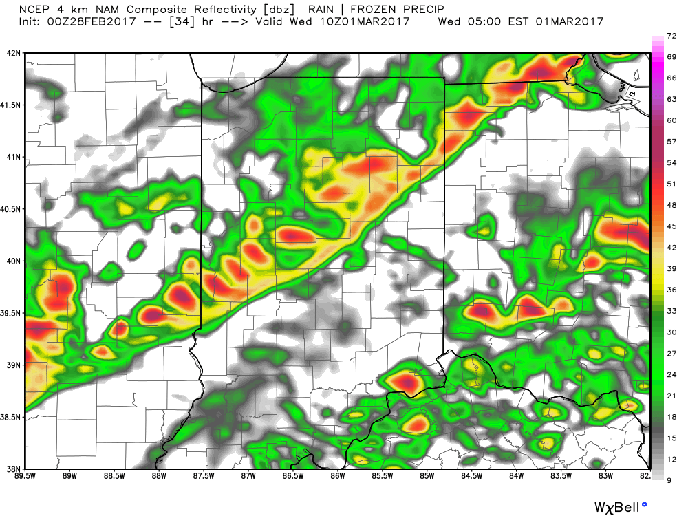 Our weather will turn quieter, but colder, as Wednesday progresses into Wednesday evening, including blustery conditions with falling temperatures.
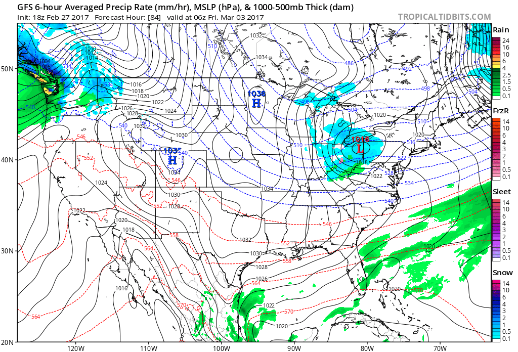 That said, the chilly late week conditions won’t last long, and a gusty southwesterly air flow will develop as early as Saturday. This will help give temperatures a significant boost Saturday afternoon after a cold start to the day. 60° is possible Saturday afternoon and the mercury may approach 70° Sunday!
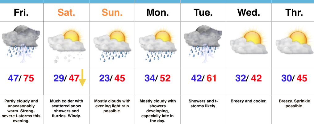 Highlights: