Updated 02.24.25 @ 6:40p
You must be logged in to view this content. Click Here to become a member of IndyWX.com for full access. Already a member of IndyWx.com All-Access? Log-in here.

Feb 24
Updated 02.24.25 @ 6:40p
You must be logged in to view this content. Click Here to become a member of IndyWX.com for full access. Already a member of IndyWx.com All-Access? Log-in here.
Permanent link to this article: https://indywx.com/video-stronger-storm-system-on-the-horizon-early-next-week/
Feb 23
Updated 02.23.25 @ 7:35a After a frigid stretch, February will close with significantly milder conditions. We’re heading into 50° territory tomorrow and push for 60° Wednesday! A couple of weak,…
You must be logged in to view this content. Click Here to become a member of IndyWX.com for full access. Already a member of IndyWx.com All-Access? Log-in here.
Permanent link to this article: https://indywx.com/a-little-something-for-everyone-how-early-march-should-be/
Feb 21
Updated 02.21.25 @ 7:24a As we get set to push into the 1st month of meteorological spring, a familiar scene is likely to show up early on and that’s more…
You must be logged in to view this content. Click Here to become a member of IndyWX.com for full access. Already a member of IndyWx.com All-Access? Log-in here.
Permanent link to this article: https://indywx.com/long-range-musings-chilly-open-to-march-but-likely-gives-way-to-milder-wet-2nd-half/
Feb 05
Updated 02.05.25 @ 5:51p To say the upcoming 2-3 weeks (likely beyond) are active is an understatement of understatements. Before we talk longer range, focusing in on tonight doesn’t yield…
You must be logged in to view this content. Click Here to become a member of IndyWX.com for full access. Already a member of IndyWx.com All-Access? Log-in here.
Permanent link to this article: https://indywx.com/storms-and-rumors-of-storms-giddy-up/
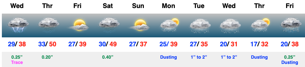
Feb 05
Updated 02.05.25 @ 7:47a
Mostly cloudy and cold conditions this morning will give way to a thickening and lowering cloud canopy through the afternoon and precipitation by late afternoon and into the evening (overspreading the region from southwest to northeast). Even a few rumbles of thunder can be expected tonight and freezing rain concerns remain across the northern tier. Here on the home front, only trace amounts (light glaze north-central) of ice can be expected.
This is only the beginning to a very active time of things over the upcoming 6-10 days.
Permanent link to this article: https://indywx.com/video-buckle-up/