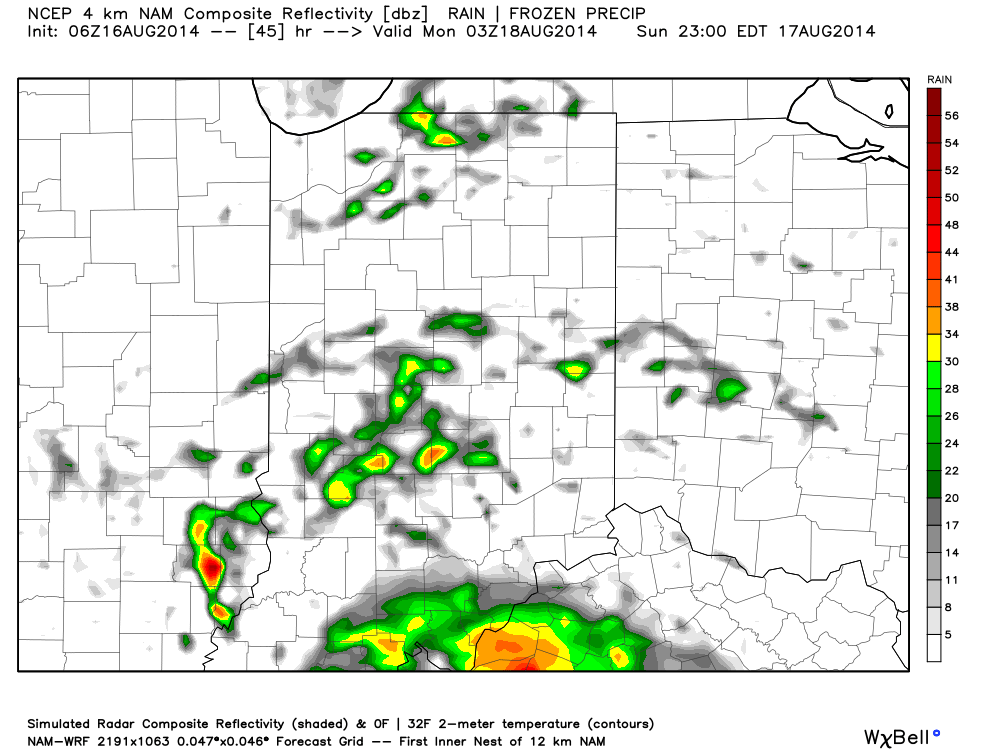
Active Week Ahead…

Sun.

Mon.

Tue.

Wed.

Thr.

Fri.

Sat.

 Status-weather-showers-day-icon

 Status-weather-showers-day-icon

 Status-weather-showers-day-icon

 Status-weather-showers-day-icon

 Status-weather-showers-day-icon

 Status-weather-showers-day-icon

 Status-weather-showers-day-icon

67/ 79

67/ 81

69/ 85

68/ 87

69/ 88

70/ 88

71/ 89 

More Like Summer…The upper air pattern this week will be unlike what we’ve seen the majority of the summer.  A ridge of high pressure will expand across the southeast region and build northwest.  Meanwhile, a trough and associated cooler air mass will impact the northern Rockies and northwest region.

Low pressure will dominate our sensible weather today with lots of clouds and widespread rain downstate.  Scattered showers and thunderstorms will impact central portions of the state.  As we progress into the work week, we’ll have to remain on our toes for thunderstorm complexes that may ride the periphery of the expanding hot dome to our south.  This will keep things rather active and unsettled through the forecast period.

The other topic of interest will be our temperatures. Whether we crack the official 90 degree mark or not is yet to be seen, but it’ll certainly feel very hot and humid around these parts through the week, especially the back half of the week.  “Air you can wear” will be the weather theme this week.

7-Day Precipitation Forecast:

  • 7-Day Rainfall Forecast: 1.50″-2.00″
  • 7-Day Snowfall Forecast: 0.00″
Cool shifts northwest this week while heat builds across the south and central.


Unsettled Weekend…

Some are waking up to the pitter-patter of rain drops this morning and this is a sign of what’s ahead this weekend.  While it won’t rain the entire time, most folks will see beneficial rainfall over the weekend.  In this case, rain is a good thing, as we’re running under normal rainfall totals month-to-date by 1.23″.

Morning showers will push through the region before dry conditions return late morning into the early afternoon.  Scattered showers will then again “dot” the central Indiana landscape this evening before potentially a more widespread rain moves in overnight.

Forecast radar at 10am:

hrrr_ref_indy_3

Forecast radar at 6pm:

hrrr_ref_indy_11

Heavier rainfall may push in overnight from the west as low pressure draws closer…

Forecast radar at 10pm:

hrrr_ref_indy_15

Sunday will have a more humid feel to the air and scattered showers and thunderstorms will remain in our forecast:

hires_ref_indy_46

This is only the beginning of a rather unsettled week ahead, including multiple rain and storm chances.  Widespread upcoming 7-day precipitation totals range between 1.5″ and 2″, but locally heavier totals can be expected.

Throw An Extra Blanket On The Bed Tonight…

Thr.

Fri.

Sat.

Sun.

Mon.

Tue.

Wed.

 Status-weather-clouds-icon

 Status-weather-clouds-icon

 Status-weather-showers-day-icon

 Status-weather-showers-day-icon

 Status-weather-showers-day-icon

 Status-weather-showers-day-icon

 Status-weather-showers-day-icon

55/ 78

48/ 76

56/ 81

64/ 83

69/ 81

70/ 81

67/ 85 

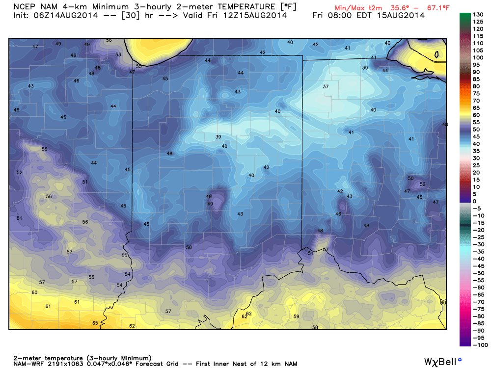
Reinforcing Cool Air Blowing In…A reinforcing push of cool air is blowing into town today and will result in a downright chilly night ahead (especially considering the time of year).  A couple showers can still be expected across south-central parts of the state, but won’t amount to much.  The big news will be the chilly temperatures tonight as we forecast upper 40s officially in the city and low to mid 40s across northeastern suburbs.  Highs will only climb into the middle 70s with lots of sunshine Friday.

Warmer And More Unsettled…Temperatures will moderate into the weekend, but we’re also going to introduce rain chances back into the picture.  Most of Saturday will remain rain-free, but we can’t rule out scattered showers and thunderstorms as the first in a series of disturbances tries to overcome initial dry air in place.  Better rain and storm chances will prevail Sunday.

Heavy Rain Next Week…Forecast rainfall numbers continue to rise next week as a series of weather makers impacts central Indiana.  A good consensus would place 1.5″ to 2″ of rain down, with locally heavier totals.  Stay tuned as we fine tune timing.

7-Day Precipitation Outlook:

  • 7-Day Rainfall Forecast: 1.5″-2″
  • 7-Day Snowfall Forecast: 0.00″

We’re enjoying another colorful sunrise across central Indiana this morning.  John Salewicz snapped this scenic photo earlier this morning.  Thanks, John!

en9WWAwc

Throw an extra blanket on the bed tonight!  Temperatures will dip into the mid to upper 40s for many.
Throw an extra blanket on the bed tonight! Temperatures will dip into the mid to upper 40s for many.

Feeling Tropical Now, But Cooler Air Coming…

Mon.

Tue.

Wed.

Thr.

Fri.

Sat.

Sun.

 Status-weather-storm-night-icon

 Status-weather-showers-day-icon

 Status-weather-clouds-icon

 Status-weather-clouds-icon

 Status-weather-clouds-icon

 Status-weather-clouds-icon

 Status-weather-showers-day-icon

68/ 80

60/ 74

54/ 76

55/ 79

58/ 80

58/ 82

64/ 85 

Air You Can Wear…We’re awaking to lots of fog and very muggy conditions.  Dew points remain in the upper 60s and lower 70s (very oppressive)!  A shower or thunderstorm will be possible really at any time today, but most likely this afternoon as the first of two cold fronts drops into the region.  Similar to yesterday, locally heavy downpours will certainly be possible with all of the moisture in the air.

A secondary cold front will blow through Tuesday with a continued chance of scattered showers and thunderstorms.  We’ll get in on a much cooler and drier air flow Tuesday evening and this will set the stage for a very pleasant rest of the work week, including below normal temperatures into the weekend.

Warming Up; Chance Of Storms…Temperatures will moderate and we’ll introduce showers and thunderstorms into your forecast Sunday.  Early thinking on next week suggests a potentially unsettled (stormy) one, but warmer than average.

7-Day Precipitation Outlook:

  • 7-Day Rainfall Forecast: 0.50″-1.00″
  • 7-Day Snowfall Forecast: 0.00″
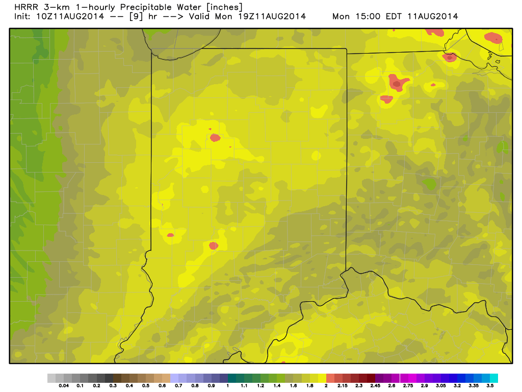
Precipitable water values will once again approach 2" today and assist in locally torrential downpours around the region.
Precipitable water values will once again approach 2″ today and assist in locally torrential downpours around the region.