Not The Best Of Weather To Close The Work Week…

Thr.

Fri.

Sat.

Sun.

Mon.

Tue.

Wed.

 Status-weather-showers-scattered-icon

 Status-weather-showers-scattered-icon

 Status-weather-clouds-icon

 Status-weather-showers-day-icon

 Status-weather-showers-day-icon

 Status-weather-storm-night-icon

 Status-weather-showers-day-icon

50/ 59

49/ 57

41/ 59

44/ 62

59/ 72

52/ 65

43/ 59 

Not “Chamber Of Commerce” Weather…A frontal boundary will slip through the region this evening before stalling just south of Indianapolis.  An area of low pressure will move along the front Friday while chilly Canadian high pressure to our north tries to suppress things.  The battle ground will lie across central portions of the Ohio Valley.  Pack the rain gear and the cool weather attire.

Today, anticipate showers and rather gloomy conditions.  We’re not anticipating any sort of heavy rainfall across the region, but instead mostly light rain with embedded pockets of moderate rainfall.  Another push of rain will move into town Friday.  Heaviest rainfall should primarily fall along the I-70 corridor and points south Friday.  Total rainfall from today and Friday should range from 0.25″ to 0.50″ with some heavier totals possible downstate.

Not A Bad Weekend…We’ll likely get some dry time in this weekend as the region remains in between weather systems over the Saturday-Sunday period.  After a mainly dry Saturday, rain chances return Sunday.

Bigger Storm Early Next Week…A rather robust storm system will impact the region Monday night into Tuesday with heavy rain potential and the threat of strong to severe thunderstorms.  We’ll keep a close eye on things as we move through the weekend and update the forecast accordingly.

Upcoming 7-Day Precipitation Forecast:

  • 7-Day Rainfall Forecast: 2.00″ – 3.00″
  • 7-Day Snowfall Forecast: 0.00″ 

John Salewicz took this stellar photo of the lunar eclipse Wednesday morning.  Thanks, John!

BzcBzRZCYAAuueD


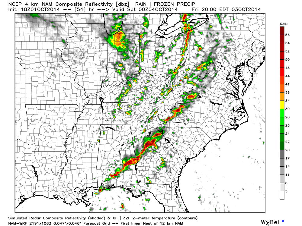
Our forecast radar products show another slug of moisture aimed at a Friday AM arrival.

Tuesday Morning Rambles…

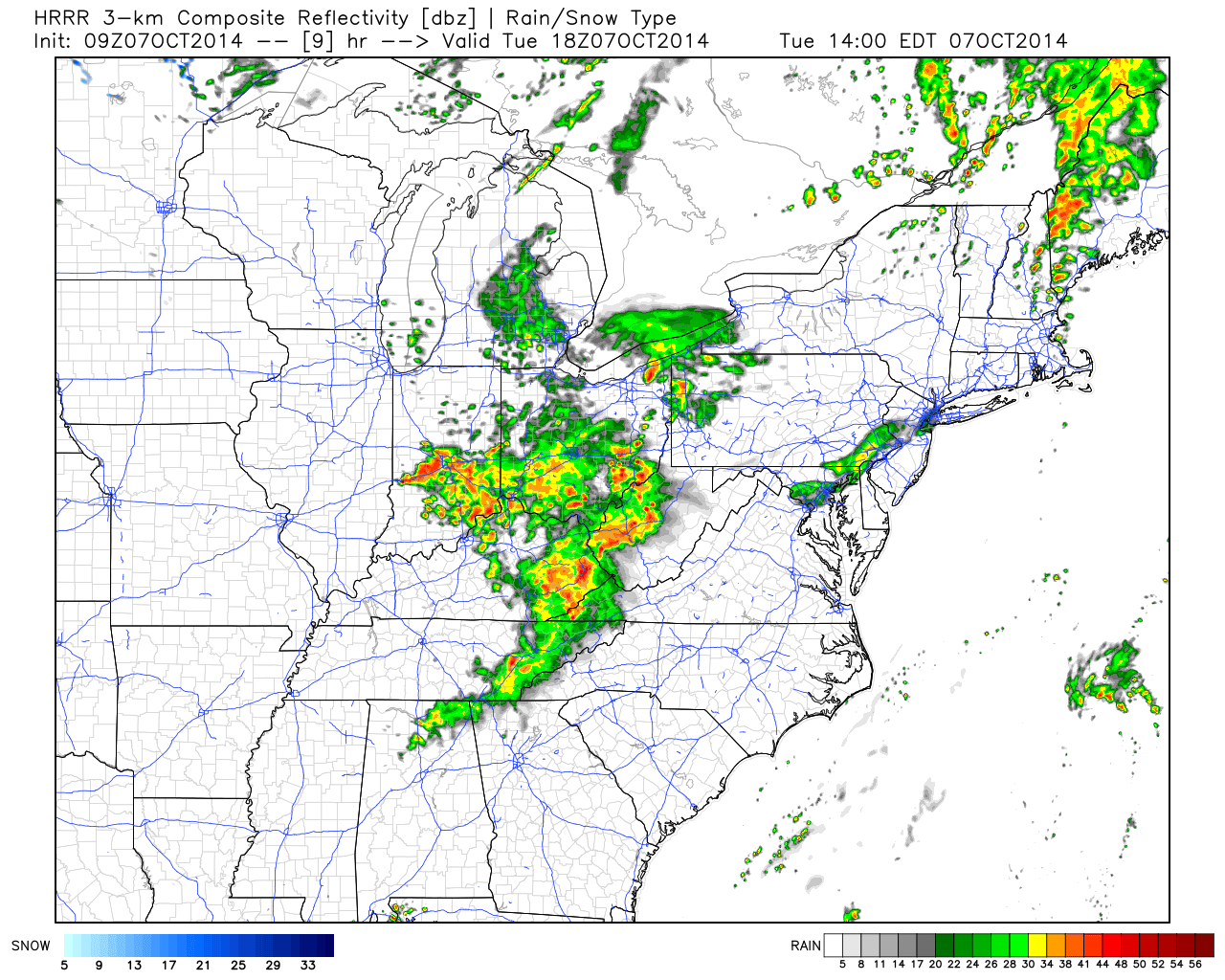
1.) We posted our weekly outlook last night and this can be found below.  An active weather pattern continues.  2.) A cold front will move through the region later this evening. As a result, showers and embedded thunder will be around into the afternoon hours before drier, cooler air builds in tonight behind the front.  Forecast radar shows rain and embedded storm chances continuing into the afternoon:

hrrr_ref_ma_10

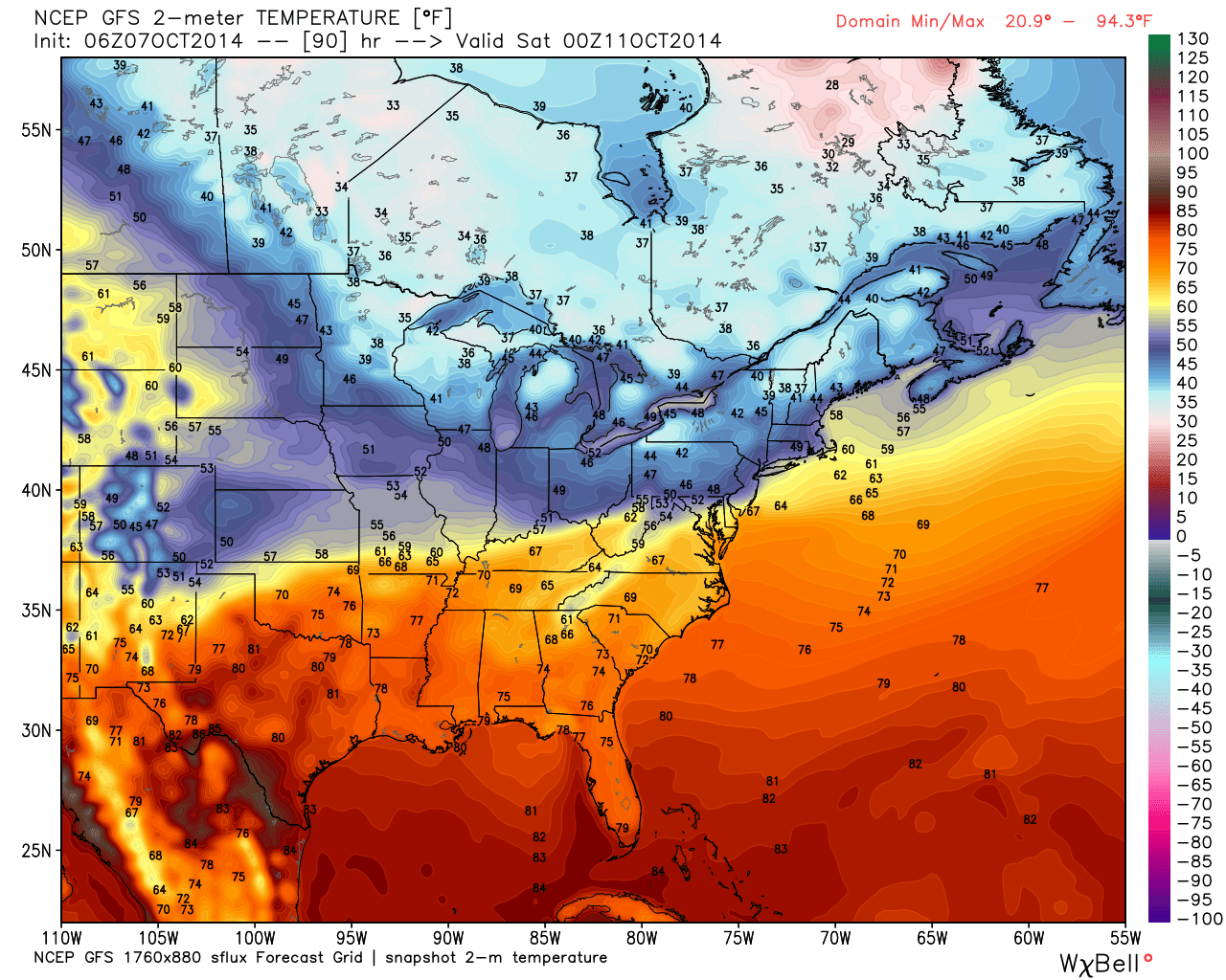
3.) Wednesday looks like the pick of the week with plentiful sunshine and pleasantly cool temperatures.  4.) Rain and storm chances return as early as Thursday into Friday.  5.) Friday stands to be quite an ugly day with rain chances and a new push of unseasonably chilly air.  A big thermal fight will be in place Friday as portions of northern Indiana don’t make it out of the 40s while temperatures across far southern areas of the state go into the 70s.  More specific to our region, look for falling daytime temperatures starting in the upper 50s.

gfs_t2m_east_31

Weekly Outlook: Active And Cool!

Another active period of weather is in store for the region. (After an extended stretch of pleasant conditions from late September into the opening of October, I guess we shouldn’t complain too much).

Dry days will be at a premium over the course of the upcoming 7-days.  The final in a series of disturbances in the fast northwest flow will blow through the region Tuesday.  This will offer up a threat of scattered showers and a possible rumble of thunder through the daytime hours. Latest forecast radar data suggests showers and embedded thunder will be ongoing Tuesday morning.

hrrr_ref_mc_10

After a dry day Wednesday (filled with lots of sunshine), we anticipate clouds and rain to quickly return as early as Thursday.  Forecast models handle the evolution of things differently at this juncture. For now, we’ll side with a blend of the GFS and Euro and serve up best rain chances late Thursday into Friday, followed by less concentration of rain Saturday, coupled with cool north winds.

gfs_slp_precip_conus_21

Saturday is a tough call at this point.  The cold front will be south of our area and chilly Canadian high pressure will be building in, but we may keep considerable cloudiness and pesky showers around (similar to last Saturday?). Stay tuned as we continue to fine tune.

Note the cooler than normal air settling in over the weekend.

gfs_t2m_anom_conus_21

7-day rainfall numbers vary greatly from model to model.  Upcoming weekly rainfall totals range from as little as 1″ to as much as 2″.  The Canadian model is the most aggressive, suggesting over 2″ on a widespread basis.

cmc_total_precip_mc_33

Just beyond this time next week we may be looking at an even more significant storm system, but we still have time to fine tune things as we move forward.

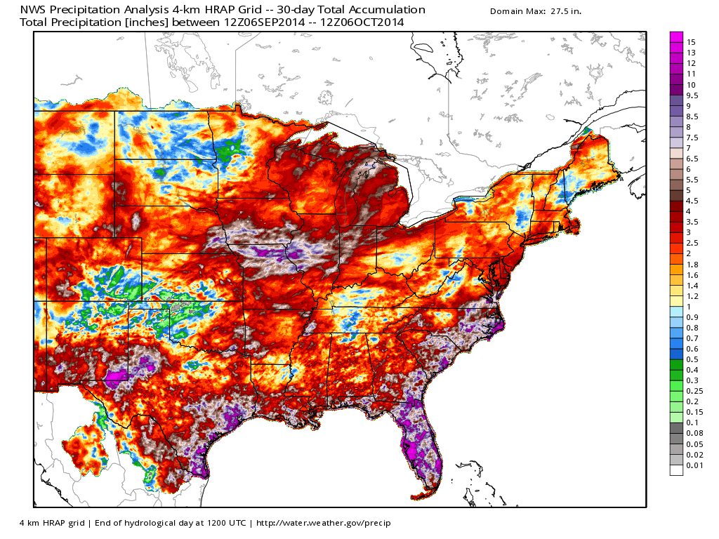
Despite the dry weather late September through October’s open, the past 30 days have featured beneficial to excessive Corn Belt rainfall…

nws_precip_east_30

Year-to-date has featured a wet eastern region.  Also note the dry pattern across the southwest (some places under 1″ YTD)!  Officially, we’re just slightly wetter than normal at IND, year-to-date (+0.53″).

nws_precip_conus2_270

Thinking longer term towards the darker, colder, and snowier months ahead… The JAMSTEC remains “bullish” on a regime plenty capable of delivering the cold and snowy “goods” for the region…  BTW- we usually post our annual winter outlook the first Friday of October.  Things have been very hectic as of late and we’re going to have to delay this release by a few weeks….

ssta.glob.DJF2015.1sep2014temp2.glob.DJF2015.1sep2014tprep.glob.DJF2015.1sep2014

Periods Of Storms; BIG Push Of Chilly Air On The Way…

Thr.

Fri.

Sat.

Sun.

Mon.

Tue.

Wed.

 Status-weather-showers-day-icon

 Status-weather-storm-night-icon

 Status-weather-showers-scattered-icon

 Status-weather-showers-day-icon

 Status-weather-clouds-icon

 Status-weather-showers-day-icon

 Status-weather-clouds-icon

61/ 83

46/ 70

43/ 49

40/ 57

44/ 64

49/ 64

48/ 70 

Changes…BIG weather changes begin today as a warm front lifts through the region.  This will lead to a warm and windy afternoon with showers and a possible rumble of thunder arriving as early as the morning rush.  Periods of showers and thunderstorms will continue this afternoon and evening, but we also want to note there will be plenty of dry time in between rain drops.  A bigger push of showers and thunderstorms will blow into town tonight into the wee morning hours Friday.  A couple of these storms may reach severe levels, especially for western communities.  Damaging straight line winds are the biggest concern.

Showers and thunderstorms continue Friday, but the bigger weather story will become our temperatures as a MUCH colder air mass rushes into the area Friday evening on a gusty northwest wind.  Falling temperatures can be expected through the afternoon Friday so you’ll want to be sure to pack the jacket and cold weather gear tomorrow.

Chilly Weekend…Well below normal temperatures can be expected this weekend along with unsettled conditions.  Saturday continues to look like a mostly cloudy and blustery day with periods of drizzle and/ or sprinkles.  Sunday will feature more in the way of sunshine, but caution we may also deal with widely scattered light showers.

Timing Issues…We’ll fine tune early next week once our first storm system moves through the region. As of now, we target Tuesday as the best day of showers, but timing issues abound.  More on this later.

Upcoming 7-Day Precipitation Forecast

  • 7-Day Rainfall Forecast: 1″ – 1.50″
  • 7-Day Snowfall Forecast: 0.00″

John Salewicz sent in this great sunset photo on the Carmel/ Zionsville line Wednesday evening. Thanks, John!

By5hQFxCAAEPvEf

Well-Advertised Major Changes Waiting On Deck…

Thursday will begin the major shift from relatively mild and stable weather that we’ve enjoyed for the past week and a half to one that’s drastically different, and much more resemblant of November by Saturday.

First rain drops will likely splatter on wind shields as early as the morning commute across central Indiana.

hrrr_ref_indy_16

We’ll then see a “lull” in the action through the majority of the day before more widespread showers and embedded strong to severe thunderstorms rumble in Thursday night into Friday morning.  Here’s a look at forecast radar Friday morning.

hires_ref_ky_43

The Storm Prediction Center does highlight western sections of the state for a Slight Risk of severe weather Thursday.  We’ll continue to monitor things closely.  Localized damaging straight line wind is the primary severe threat in the highlighted risk area.

day2otlk_1730

We also want to highlight Friday afternoon and evening for another round of showers and embedded thunder.

hires_ref_ky_55

Rainfall totals should reach between 1″-2″ with locally heavier amounts between the period of Thursday morning and Saturday morning.

hires_t_precip_indy_20

The rain and gusty storms will fall ahead of a strong autumn cold front that will send temperatures on a rapid downward trend come Friday night.  A deep trough will carve itself out over the eastern region Saturday and ultimately have temperatures all the way to the Gulf Coast feeling November-ish by Saturday (perfect football weather, IMO).

By the way, the record low max will be in jeopardy Saturday (49 degrees, courtesy of Sean Ash) as many central Indiana communities may struggle to make it out of the 40s for highs with considerable cloudiness, pesky drizzle, and gusty winds.  Have the jackets and sweaters ready, friends!

gfs_namer_072_500_vort_ht_s


gfs_t2m_min_east_39