Our immediate focus has to do with another frosty morning Thursday (many will have low temperatures in the lower to middle 30s come daybreak with plenty of frost). That said, changes are coming as we transition from eastern troughiness to brief ridging come early week.
We’ll replace the frosty 30s with a couple days of highs in the lower to middle 70s early next week.
Upper air pattern centered on next Monday:
We’ll flirt with 70 degrees Saturday before a Sunday “speed bump” (highs in the lower 60s), but highs Monday and Tuesday will likely be around, or above, the 70 degree mark with a breezy southwest flow.
Forecast models differ on the next round of rain, but we’ll highlight the Tuesday-Wednesday time frame for our next best chance of widespread rains and embedded thunder along with a cool down for mid and late week.
Frosty…It’s the coldest morning for most since last May. Frost is rather widespread here at IndyWx.com HQ this morning (southern Boone county). Thankfully, brilliant mid-Autumn sunshine will help temperatures warm into the upper 50s this afternoon (still roughly 5 degrees below average). We’ll do it all again tonight as lows dip into the middle to upper 30s for many outlying communities.
Weak Weather System…First, most of, if not all Thursday will be dry with increasing late day clouds. A couple very light showers will move across central Indiana late Thursday night into early Friday. This won’t be a big deal in the least and we’ll quickly get back to dry weather.
Nice Weekend…A nice and dry weekend awaits with moderating temperatures. All-in-all, it’ll be a beautiful autumn weekend.
Warmer Ahead Of The Next Storm System…While temperatures will moderate into the lower 70s early next week, it’ll come at a cost and that will be our next chance of widespread rain and embedded storms. We’ll get back to cooler air by the middle of next week.
Upcoming 7-Day Precipitation Forecast:
7-Day Rainfall Forecast: 0.25″ – 0.50″
7-Day Snowfall Forecast: 0.00″
John Salewicz sends in this brilliant shot of fall color that’s reaching peak across Zionsville. Flat out awesome, John! Thank you!
It’s a wet and stormy start for many this morning. Despite some local downpours and embedded thunder, all of this morning’s storms will remain below severe levels. Periods of showers…
You must be logged in to view this content. Click Here to become a member of IndyWX.com for full access. Already a member of IndyWx.com All-Access? Log-in here.
Cool Autumn Weekend…The rest of today will feature mid and high level cloudiness, but dry conditions. Cool north to northeast winds will blow and require jackets or sweaters if venturing outside for too long of a time.
Be sure to enjoy the brief dry weather Saturday as shower chances return as early as Sunday, particularly during the afternoon hours and on. Moisture will begin to surge back north in advance of a storm system that will lead to some rough weather around these parts to open the new work week.
Monday Severe Potential…Gusty southwest winds will usher in a warmer and more humid feel of things Monday out ahead of our next strong storm system. We continue to closely monitor the potential of severe weather Monday night into Tuesday morning and want to highlight the threat of damaging straight line wind potential embedded with a possible squall line. Beforehand, showers and embedded thunder will be possible during the daytime Monday.
We note the GFS remains consistent on strong to severe storm potential Monday night into Tuesday morning while the European is more delayed (suggesting more of a threat during the day time Tuesday). For now, we’re leaning more towards the GFS and we’ll have more on the early week severe threat Sunday. Locally heavy rain is also a good bet during this time, including widespread 1″-1.5″, with locally heavier totals.
Taking The More Optimistic Approach…Some forecast data wants to keep considerable cloudiness and pesky light showers around into the mid week period, but for now we’re still going with the more optimistic outlook and including drier weather along with cooler temperatures for the balance of the upcoming work week.
Upcoming 7-Day Precipitation Forecast:
7-Day Rainfall Forecast: 1-2″
7-Day Snowfall Forecast: 0.00″
We continue to highlight Monday night/ Tuesday morning for the potential of severe weather, including damaging straight line winds. Here’s what the high resolution NAM simulated radar suggests at 8p Monday local time.
While rain and chilly air are the headlines as we wrap up the work week and open another important college football weekend (my anticipation is building rapidly for my beloved Tigers taking on a dangerous MS. State squad Saturday afternoon- WAREAGLE, btw), our attention is continuing to focus in on the potential of strong to severe thunderstorms Monday night and Tuesday morning across the region.
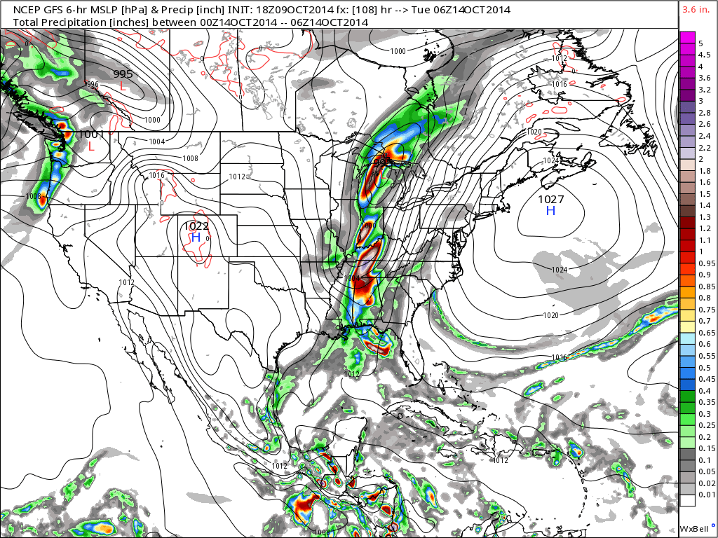
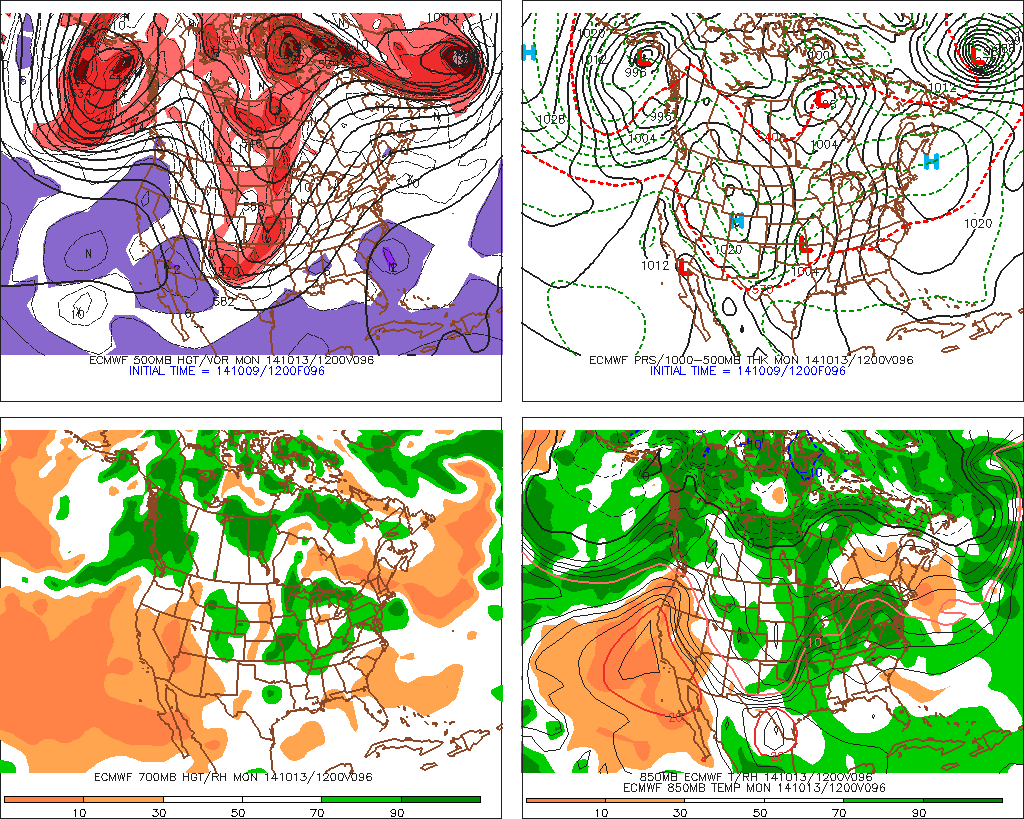
Forecast models continue to suggest strengthening low pressure will track northeast from MO into IL and MI Monday night into Tuesday morning.
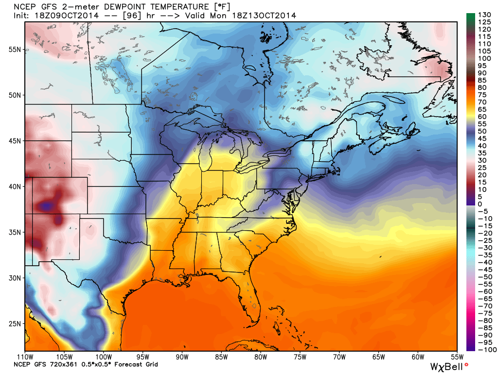
The region will briefly get into a warm and humid environment Monday and Monday night (plenty capable of fueling strong to severe thunderstorm development). Temperatures in the 70s will combine with dew points in the low to mid 60s.
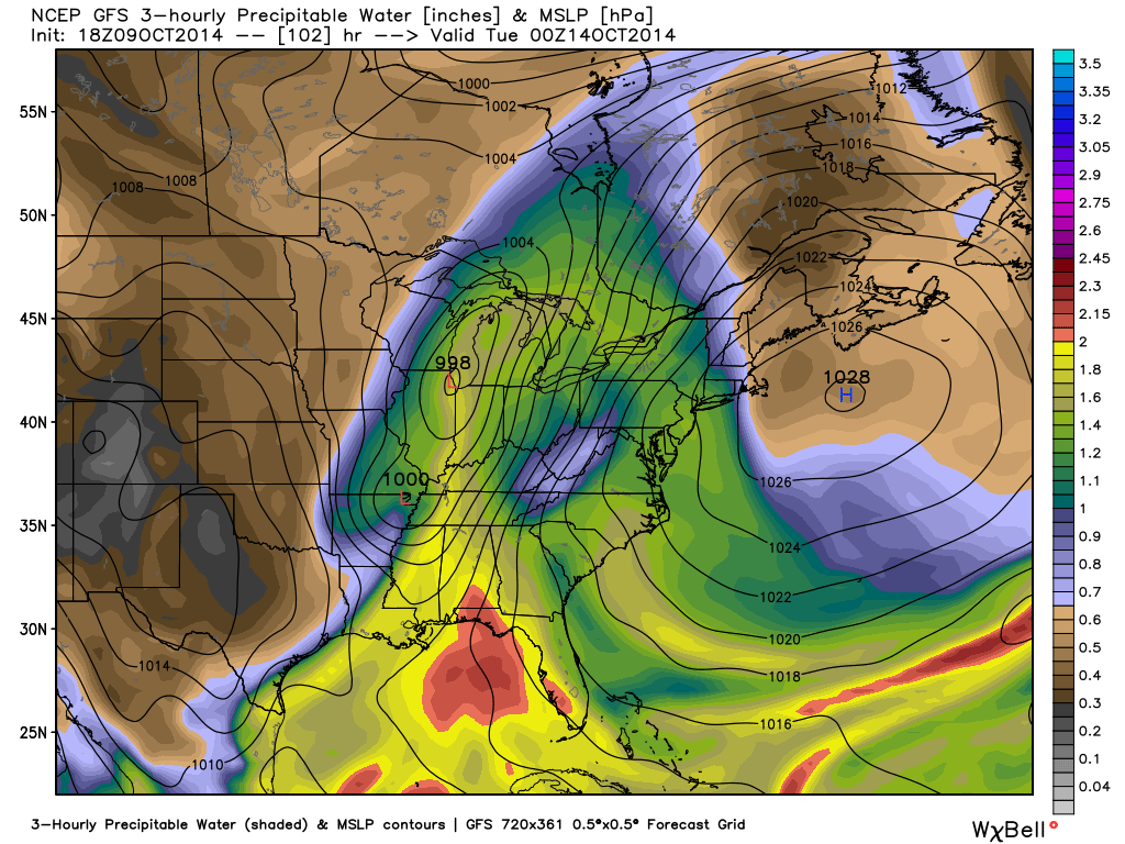
A ribbon of precipitable water values will approach 2″ across the state Monday night. This supports heavy and locally flash flood producing rainfall. Forecast models continue to key on additional Monday-Tuesday rainfall in the 1-2″+ range.
We’ll continue to closely monitor the data as we move forward, but at this early juncture, make a mental note to be weather-aware Monday night into Tuesday morning as strong to severe thunderstorm potential develops.