Hot And Humid With Storms, But Relief Is Coming…
Screen Shot 2015-07-28 at 11.34.23 PMHighlights:

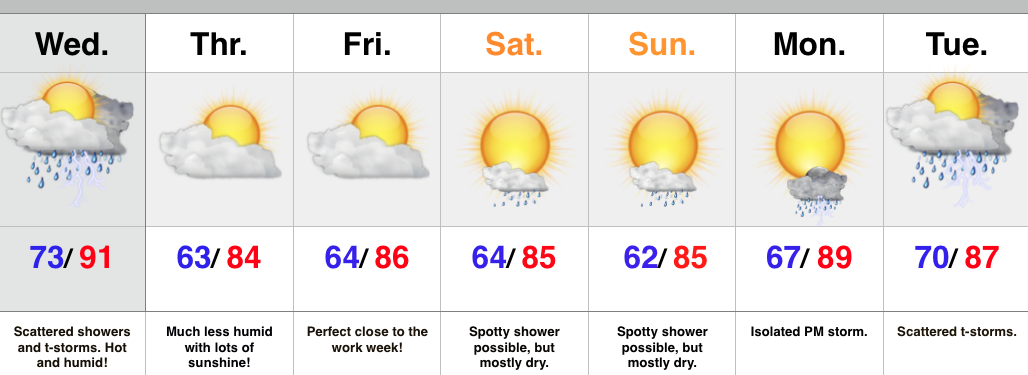
  • Thundery Wednesday
  • Much more refreshing feel to close the week
  • Storm chances return early next week

A cold front will move through the region Wednesday afternoon and evening.  The front will slice into a very warm and humid air mass so strong to severe thunderstorms will be possible, especially late morning into the afternoon/ evening.  We’re not forecasting widespread severe, but with all of the moisture in the atmosphere, locally heavy rain and additional flash flooding can’t be ruled out.

At any rate, a much more pleasant feel can be expected to wrap up the work week. We note dew points plunge from the upper 70s Wednesday morning into the upper 50s Thursday morning.  Talk about nice!

While we have to maintain a mention of a shower over the weekend, the majority will be rain-free.  The pesky NW flow aloft may push a weak disturbance into central IN so we have to mention the threat of an isolated shower Saturday into Sunday.

Looking ahead, next week is potentially an active one, including a heavy rain threat followed by a big push of early August cool air.

Upcoming 7-Day Rainfall Forecast: 1.5″ – 2″ (locally higher totals under storms)

Humid Feel Now, But What About Storm Chances?

It certainly feels oppressive across central IN this evening.  This evening’s video update highlights the humid feel and storm chances in the days ahead.  Also, what about that cooler period…

You must be logged in to view this content. Click Here to become a member of IndyWX.com for full access.  Already a member of IndyWx.com All-Access?  Log-in here.

Warmth & Humidity Build; Storms Return…

We’ve enjoyed a stretch of dry and pleasant air, but that will come to an end this weekend as warmth and humidity build and help fuel storms at times later…

You must be logged in to view this content. Click Here to become a member of IndyWX.com for full access.  Already a member of IndyWx.com All-Access?  Log-in here.

Can’t Ask For Anything Better This Time Of Year…

Screen Shot 2015-07-23 at 11.28.22 PMHighlights:

  • Beauty of a close to the work week
  • Humidity and storm chances return this weekend
  • Turning hot ahead of a cold front next week

We simply can’t ask for more beautiful weather this time of year than what we’ll enjoy to wrap up the work week.  (3 day weekend, anyone)?  Make time to spend outdoors today!

Warmth and humidity will be on the uptick this weekend and with the increasingly humid air, isolated to widely scattered thunderstorms can be expected.  That said, there’ll be more dry time than not this weekend so there’s no need to cancel any of those outdoor plans.

Heat will build early next week, along with continued “splash and dash” storm coverage- particularly of the PM variety.  Best rain and storm chances should come Thursday as a cold front draws near.

Upcoming 7-Day Rainfall Forecast: 0.50″ – 1.00″ (locally heavier totals under stronger storms)