Growing Severe Threat Sunday…

We have growing concerns of a severe weather event Sunday afternoon and evening across the state.  This morning, the Storm Prediction Center (SPC) has included most of Indiana in an “Enhanced” risk of severe weather.  From this distance, all modes of severe weather seem possible, including large hail, damaging winds, and even a tornado or two.
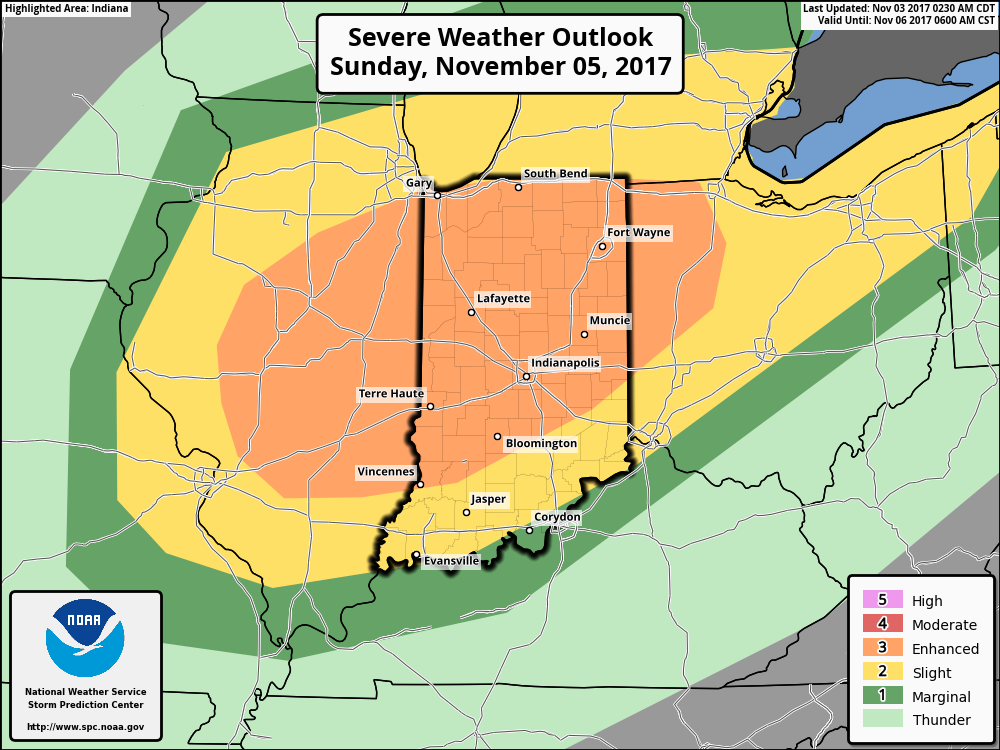
A trough and associated cold front will slice into an unseasonably warm and increasingly moist air mass Sunday.  Ahead of the approaching front, temperatures should climb into the lower 70s Sunday afternoon (average high is in the upper 50s) and dew points will reach the lower to middle 60s.  While the developing surface low isn’t expected to be terribly strong, as this feature moves northeast, it’ll help drag a cold front into this warm and increasingly unstable air mass late Sunday.  From this distance, conditions seem favorable for a couple of super cells to develop Sunday afternoon and evening.  We’ll have to keep a close eye on the northward extent of the warm front as this would be the areas of greatest concern for potential tornadic activity Sunday afternoon.  Large hail and damaging winds are also included in Sunday’s severe threat.  We’re in the second severe weather season, after all, and this kind of event isn’t unusual.  Late November 2013 comes to mind.

It’ll be important to remain weather-aware Sunday and stay tuned all weekend for future updates.  We’ll transition to a much cooler regime (back to below average) next week.

A cold front will slice into unseasonably warm and moist air Sunday afternoon and evening. A severe weather episode is a growing concern. Remain weather-aware.


A Cold Halloween On Tap…

Highlights:

  • Cold and blustery Halloween
  • Unsettled, milder weather builds in
  • Stronger cold front arrives early next week

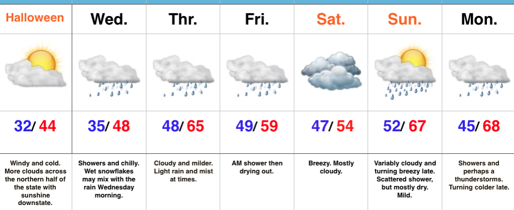
Spooky Winds…Northerly breezes are strong and gusty and leading to wind chills in the lower-middle 20s across central Indiana this morning.  Heavier winter coats will be a smart choice out the door!  Otherwise, we’re a state divided from a cloud perspective: the southern half of Indiana will get in on the sunny act much sooner than the northern half of the state.  As we look towards the all-important trick-or-treat weather tonight, anticipate dry conditions, lighter winds, and unseasonably chilly conditions continuing.

Our next storm system will approach Wednesday with showers.  Rain may be mixed with wet snow or sleet Wednesday morning, but with temperatures above freezing, don’t look for any accumulation.  Periods of showers and light rain will continue Thursday into Friday morning.  Heavy rain won’t occur, but it’ll be damp at times.  Saturday is a bit tricky- some solutions keep rain around, but we’re choosing the more “optimistic” approach for the purpose of this forecast update.  Stay tuned.

Saturday will feature considerable cloudiness, slightly cooler air, and breezy conditions before a warmer close to the weekend.  A southwesterly flow will help boost highs into the upper 60s Sunday afternoon ahead of an approaching cold front.  That cold front will slide through here with showers and a couple claps of thunder Monday.  Much colder air returns Monday night into Tuesday.

Upcoming 7-Day Precipitation Forecast:

  • Snowfall: Trace
  • Rainfall: 0.50″ – 1.00″

Sunny Days; Pattern Change On The Horizon…

Highlights:

  • Extended stretch of dry, sunny weather
  • Late weekend cold front
  • Much colder close to the month looms

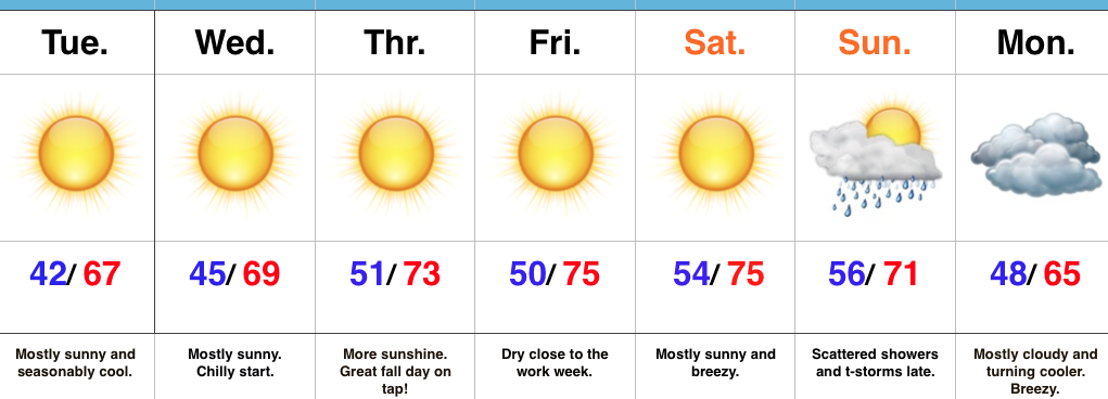
Ideal, Crisp Fall Day…Sheltered, lower lying communities are waking up to temperatures in the middle and upper 30s this morning with patchy frost.  The rest of us are in the lower to middle 40s with just enough breeze preventing a deeper overnight fall.  All of us we’ll moderate into the mid and upper 60s this afternoon under a clear sky.  Those mostly sunny conditions will continue into mid and late week with moderating temperatures.

Our next storm system will arrive during the second half of the weekend in the form of a cold front.  Scattered showers and thunderstorms will move in Sunday afternoon and evening ahead of the front.  Cooler air will invade behind the frontal passage, but the true chilly stuff will press in early next week.  Speaking of chilly weather, medium and longer range data continues to paint a cold close to the month and open to November.  Warm costumes will be needed for trick-or-treating this year.

Upcoming 7-Day Precipitation Forecast:

  • Snowfall: 0.00″
  • Rainfall: 0.25″ – 0.50″

Weekend Warmup Ahead Of The Coolest Air Of The Season…

Highlights:

  • Weekend Warmup
  • Scattered showers Sunday morning
  • Gusty winds and falling temperatures

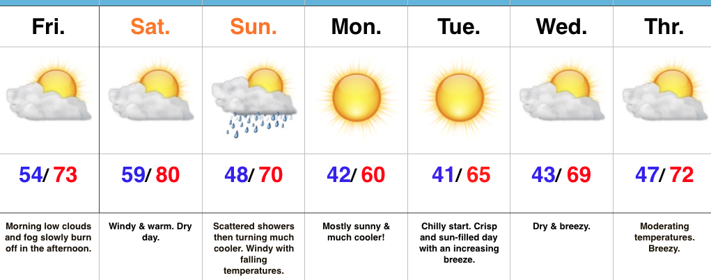
Weekend Changes…Before we discuss our weekend weather, we should finally see the “doom and gloom” depart later this afternoon as enough of a southwest breeze and drier air helps scour out the low clouds, drizzle, and fog.  Improvements will come slowly, but surely as we progress into the afternoon hours.

A delightful Saturday is dialed up, including what’s very likely to be our last 80° reading until next spring.  Northern portions of the state will get in on some shower activity Saturday, but we’ll remain dry and windy here on the home front.  As the cold front draws closer to the region, scattered showers and embedded thunder will blow into town Sunday morning.  This won’t be a significant rain event and the much bigger deal will be the falling afternoon temperatures and gusty northwest breeze.  You’ll need a jacket before the sun sets Sunday.

The cooler ending to the weekend is a harbinger of things to come as we open the new work week.  In fact, temperatures will fall low enough to warrant a patchy frost risk for outlying areas away from the metro Monday and Tuesday mornings.  Sun-filled skies and cool, crisp afternoons are on tap next week.

Upcoming 7-Day Precipitation Forecast:

  • Snowfall: 0.00″
  • Rainfall: 0.10″ – 0.25″

Ups And Downs Of Autumn…

Highlights:

  • Early morning rain ends
  • Cooler air arrives
  • Warm Saturday
  • Much cooler close to the weekend

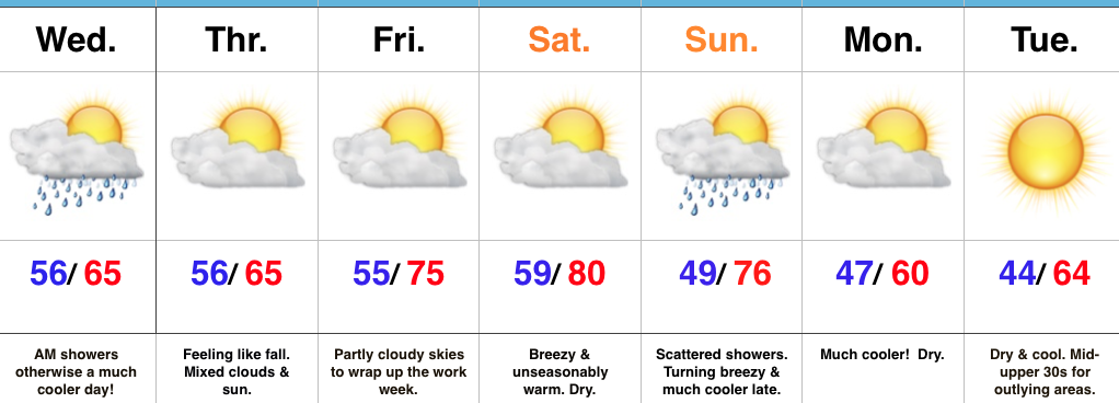
Buckle Up…Early morning showers and embedded thunder should press northeast of the region before the rush gets underway.  All the same, expect damp roads on the way in to work and school Wednesday morning.  Additionally, we’ll notice a much cooler feel to the day, including nearly steady or slowly falling temperatures.  After a seasonable high Thursday, dry conditions and moderating temperatures will be with us to wrap up the work week.

Our next storm system will take aim on the region this weekend.  Dry conditions will prevail Saturday, along with a gusty southwest wind that will help aid in boosting temperatures to around 80° (where’s that college football weather)?!  That southwest (warm) wind will be in advance of an approaching cold front that will deliver scattered showers Sunday.  Not everyone will get wet, but everyone will notice the much cooler close to the weekend.  Temperatures will fall Sunday evening with a gusty north breeze.

Early next week will open dry and cool.  – Just classic fall weather that most of us have come to know and love this time of year around these parts!

Looking ahead, there continue to be signs that point towards potentially a more significant shift in the weather pattern that would result in a rather dramatic cold transition to wrap up the month.  More on this later.

Upcoming 7-Day Precipitation Forecast:

  • Snowfall: 0.00″
  • Rainfall: 0.25″ – 1.00″