
You must be logged in to view this content. Click Here to become a member of IndyWX.com for full access. Already a member of IndyWx.com All-Access? Log-in here.
Category: T-storms
Permanent link to this article: https://indywx.com/video-ready-to-heat-things-up-this-weekend/
Jun 07
Another Pleasant Day Then It’s Time To Sweat…
 Highlights:
- Another pleasant day ahead!
- Dry weather continues.
- The heat is on!
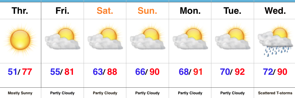
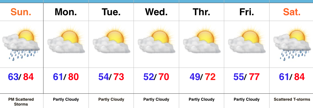
Dry Weather Continues; Summer Feel Develops…We’ll enjoy one more very pleasant and refreshing day Thursday, including plentiful sunshine, low humidity, and below normal temperatures. Many central Indiana neighborhoods will begin the day in the mid to upper 40s away from the city. Enjoy the pleasant weather while we’ve got it!
As we progress into the weekend, temperatures and humidity will begin to increase. By this time next week, overnight lows will be closer to today’s official (IND) high of 72°. One word: YUCK.
A couple of showers and thunderstorms are possible Friday afternoon, but most, if not all, of these look to remain confined to the northern third of the state. That’s the only chance of moisture until we rumble into the middle of next week. In addition to the continued bone dry conditions, unseasonably hot weather will build in over the Mid West and result in highs of 90°, or higher, Sunday into early next week.
Looking into the longer range, a more active and increasingly wet regime looks to return just past mid-month. While the early season heat and dry weather will be significant, thankfully it doesn’t look like it’ll last…
Upcoming 7-Day Precipitation Forecast:
- Snowfall: 0.00″
- Rainfall: 0.10″ – 0.25″
Permanent link to this article: https://indywx.com/another-pleasant-day-then-its-time-to-sweat/
Jun 06
VIDEO: Pleasant Weather Gives Way To Weekend Heat…
You must be logged in to view this content. Click Here to become a member of IndyWX.com for full access. Already a member of IndyWx.com All-Access? Log-in here.
Permanent link to this article: https://indywx.com/video-pleasant-weather-gives-way-to-weekend-heat/
Jun 04
Storms May Rumble In Later Today; Cooler For Midweek…
We’ve enjoyed a warm and beautiful weekend, and most of Sunday will follow that pleasant them. However, a cold front will drop south into the state later today and this “trigger” mechanism, combined with the heating of the day, will likely spark a broken line of thunderstorms. These storms will sink south into central Indiana later this evening, and a couple of storms could become strong.
Modeled radar shows how things may evolve later this evening, including time stamps at 5p, 8p, and 10p.
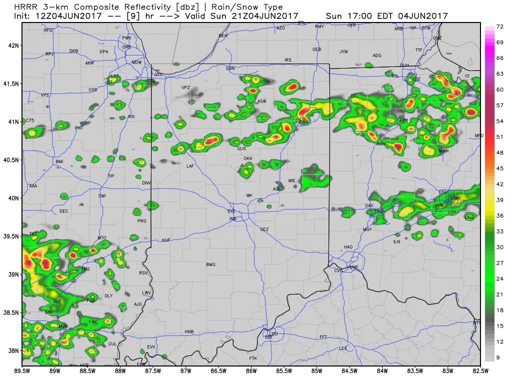
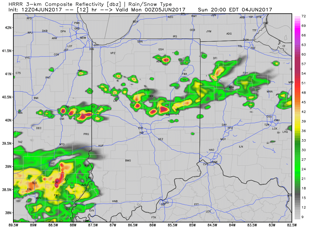
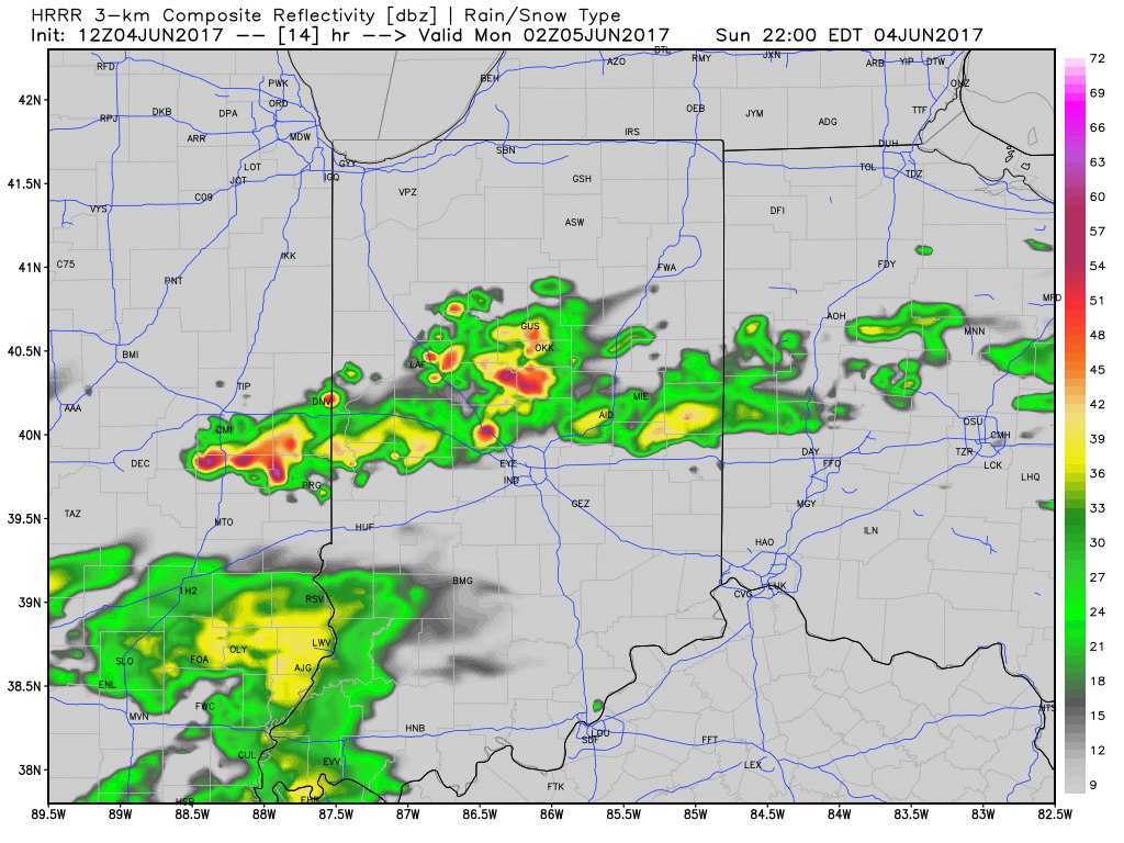 Most significant rainfall will occur across the northern half of the state, including a couple of 1″+ totals in the heavier storms.
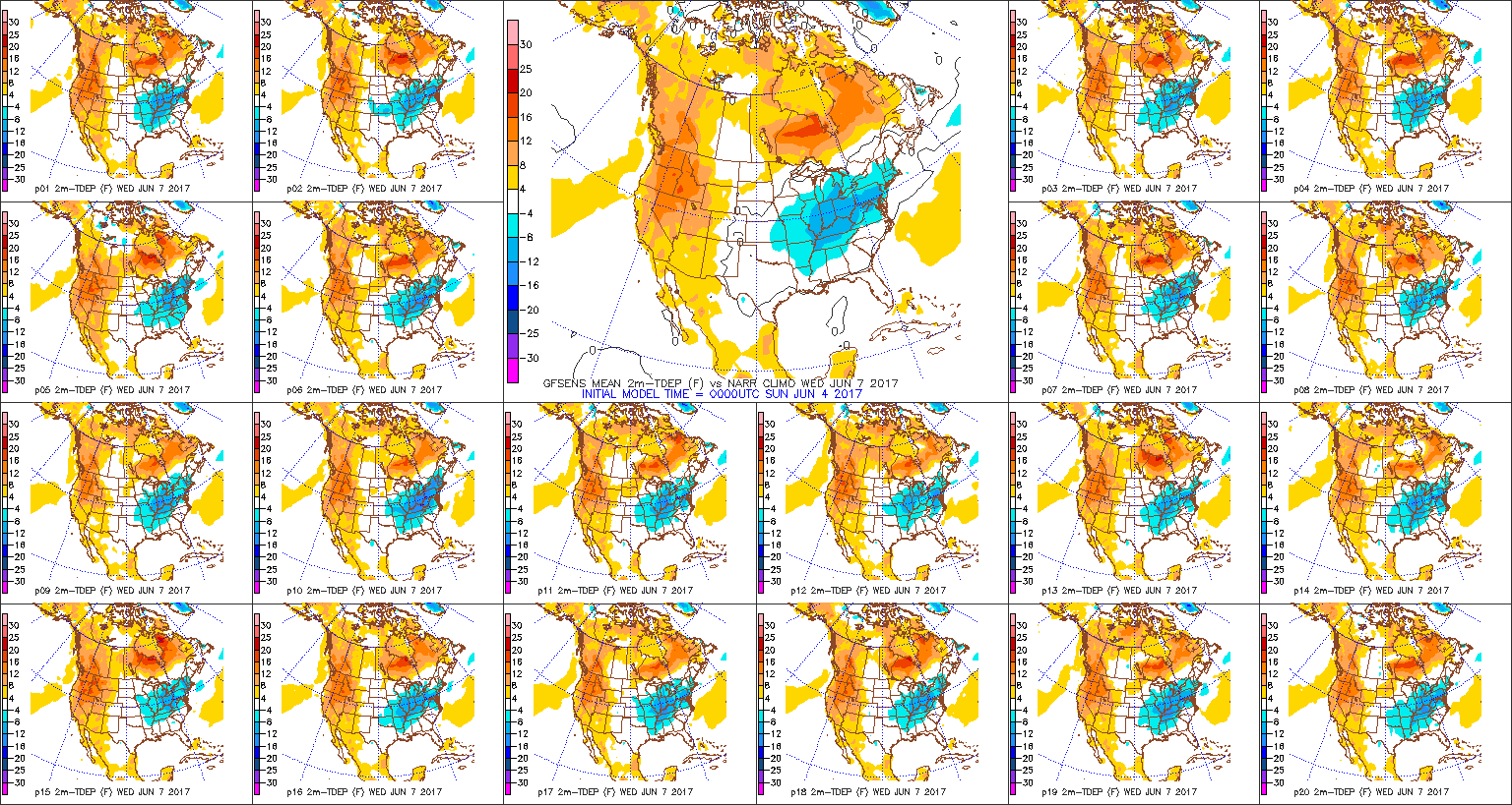
As we push into the midweek stretch, cooler, refreshing air will take up residence across the region. Temperatures will run significantly cooler than average, including lows in the upper 40s for some Wednesday and Thursday morning and highs only in the upper 60s to lower 70s. Dry weather will continue, as well.
Permanent link to this article: https://indywx.com/storms-may-rumble-in-later-today-cooler-for-midweek/
Jun 03
Overall Dry And Pleasant Weather Continues…
 Highlights:
- Scattered late-day storms Sunday
- Dry weather returns
- Cooler next week
Scattered Strong Storms Late Sunday…Our beautiful weekend weather will continue into Sunday. Expect a mostly dry day along with warm and humid conditions. A cold front will approach late in the day and we still think a broken line of thunderstorms will slip south into central Indiana Sunday evening into Sunday night. A couple of these could become strong, but a widespread severe weather event isn’t anticipated.
We’ll quickly get back to dry conditions as we open the new work week and another extended spell of rain-free conditions should carry us through the balance of the upcoming forecast period. Additionally, a notable cooling trend will engulf the region. With dry skies, low humidity, and highs in the lower 70s it’ll be picture-perfect to spend time outdoors.
Moisture will begin to return next weekend and, accordingly, we’ll introduce scattered showers and thunderstorms into our forecast next Saturday.
Upcoming 7-Day Precipitation Forecast:
- Snowfall: 0.00″
- Rainfall: 0.25″ – 0.50″
Permanent link to this article: https://indywx.com/overall-dry-and-pleasant-weather-continues/