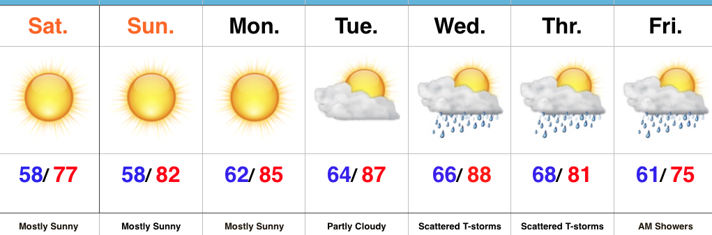
Category: T-storms
The weather this weekend has been simply stunning. We’ve enjoyed unseasonably cool and refreshing air to go along with wall-to-wall sunshine. If you’re a fan of the unseasonably refreshing conditions, you’re in luck, as another blast of September-like air will arrive next weekend.
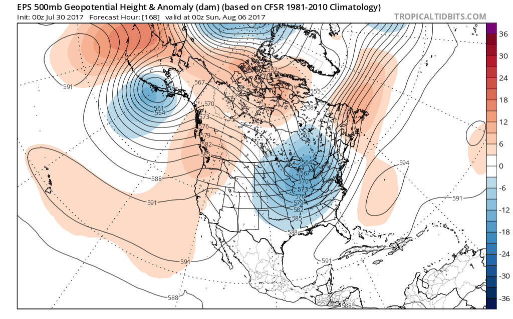
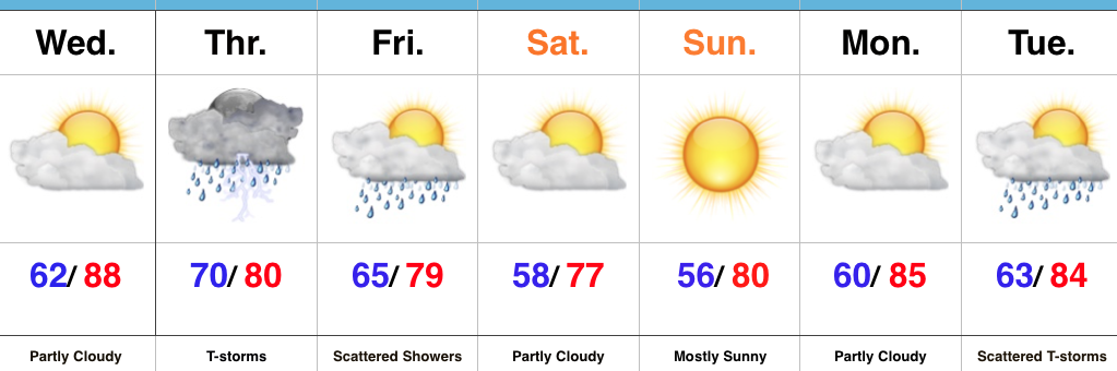
A cold front will sweep through the state Friday morning. While we’ll handle the specifics from a precipitation perspective in later posts, most widespread showers and thunderstorms appear to arrive Thursday. A deep trough will take up residence across the Mid West and East next weekend and result in temperatures more like late-September that early-August.
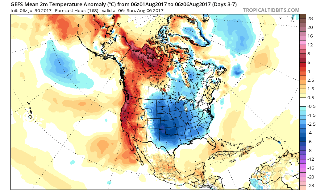 Look for fairly steady or slowly falling temperatures Friday afternoon (how often can we say that in early August?!) along with a gusty northwest breeze. That will set the tone for the weekend that will include low temperatures in the lower to middle 50s and highs in the middle 70s. Unlike this weekend, we’ll have a few more clouds and the threat of a passing shower with enough upper level energy around.
Much more later! Enjoy your Sunday, friends!
Permanent link to this article: https://indywx.com/even-cooler-next-weekend-early-taste-of-autumn/
 Highlights:
- Wall-to-wall sunshine
- Comfortable temperatures
- Rain chances return
- Even cooler next weekend
Can’t Beat This Weather…The short-term is very simple. High pressure will dominate our pattern through early next week and result in very refreshing conditions. With a north-northeast flow in place, unseasonably cool and dry air will continue to flow into the region through the weekend. Get out and enjoy it!
Temperatures will slowly moderate heading into mid week and moisture will return ahead of a cold front Wednesday into Thursday. Greatest overall rain coverage should arrive on the scene Thursday, including chances of thunderstorms. Similar to this week, the cold front will pass Thursday night/ Friday morning and result in a drier ending to the work week. An early look at next weekend shows another anomalous trough digging into the Mid West. The end result will likely be temperatures that are even cooler than this weekend. Mid-upper 70s for highs, perhaps?!
Upcoming 7-Day Precipitation Forecast:
- Snowfall: 0.00″
- Rainfall: 0.50″ – 1.00″
Permanent link to this article: https://indywx.com/refreshing-last-weekend-of-july/
You must be logged in to view this content. Click Here to become a member of IndyWX.com for full access. Already a member of IndyWx.com All-Access? Log-in here.
Permanent link to this article: https://indywx.com/video-locally-heavy-rain-thursday-unseasonably-cool-refreshing-weekend/
 Highlights:
- Turning more humid this afternoon
- Heavy rain Thursday
- Cooler and drier weekend ahead
Heavy Rain Tomorrow…Wednesday is getting off to a pleasant and beautiful start across the Hoosier state. Sunshine will be with us throughout the day, but our pleasant air mass that we’re awaking to will grow increasingly moist this afternoon and evening. Our next storm system approaches late tonight and will help push widespread rain and thunderstorms across the state early Thursday morning. With such high water content in our air mass, expect periods of heavy rain across the region. Localized flooding will result.
The trade off to the wet and stormy Thursday will be an incredible weekend. Despite a few lingering showers Friday, we’ll notice a dramatic drop in humidity Friday night and this will set the stage for a refreshing last weekend of July. In fact, temperatures will grow cool enough both Saturday and Sunday mornings to perhaps trigger a feel of early autumn for some. Plentiful sunshine can be expected along with unseasonably low dew points with a northeasterly flow in place.
Temperatures and moisture levels will slowly increase as we get into early next week. With the increasing humidity, expect increasing chances of showers and thunderstorms towards the middle of next week.
Upcoming 7-Day Precipitation Forecast:
- Snowfall: 0.00″
- Rainfall: 2.00″ – 3.00″
Permanent link to this article: https://indywx.com/heavy-rain-and-storms-thursday-phenomenal-weekend-ahead/
You must be logged in to view this content. Click Here to become a member of IndyWX.com for full access. Already a member of IndyWx.com All-Access? Log-in here.
Permanent link to this article: https://indywx.com/video-stormy-weather-unfolds-late-wednesday-night-early-fall-like-weather-this-weekend/
