
You must be logged in to view this content. Click Here to become a member of IndyWX.com for full access. Already a member of IndyWx.com All-Access? Log-in here.
Category: T-storms
Permanent link to this article: https://indywx.com/wet-close-to-2018-on-deck/
Dec 27
Tracking 2 Rain Events; Cold Open to 2019…
 Highlights:
- Wet with a few t-storms
- Dry weekend
- Wet then cold to open 2019
Rain Gear Needed…The pattern is transitioning from the predominantly mild stretch of the past couple weeks to one that will turn much colder as we move into January. In between? Active times, as we’re tracking two big storm systems between now and NYE.
The initial push of moisture has reached the I-65 corridor as of this forecast issuance early Thursday morning. Periods of rain will continue through a good chunk of the day and we may even throw in some thunder into the mix later this evening- especially across southern portions of the state. The other big story today? Strong and gusty southerly winds.
Rain will end later tonight with dry, blustery, and colder times returning as we close the week. Highs tomorrow will come predawn before falling through the day. Dry and seasonable times will continue as we move through the last weekend of 2018.
A new storm system promises a return of wet times as we get set to ring in the new year. Definitely plan on having the rain gear handy as you head out to those New Year’s Eve parties Monday. Heavy rain is possible at times. As the area of low pressure tracks northeast, it’ll swing a cold front through here Monday night and we’ll turn sharply colder with snow showers on New Year’s Day, itself.
Permanent link to this article: https://indywx.com/tracking-2-rain-events-cold-open-to-2019/
Dec 26
Rain Arrives Tomorrow…
You must be logged in to view this content. Click Here to become a member of IndyWX.com for full access. Already a member of IndyWx.com All-Access? Log-in here.
Permanent link to this article: https://indywx.com/rain-arrives-tomorrow/
Dec 02
Chill Returns Along With Opportunities For Snow…
You must be logged in to view this content. Click Here to become a member of IndyWX.com for full access. Already a member of IndyWx.com All-Access? Log-in here.
Permanent link to this article: https://indywx.com/chill-returns-along-with-opportunities-for-snow/
Dec 01
From Storms To Snow; Active Week Ahead…
Our week-ahead outlook is focused on everything from storms to a return of unseasonably cold conditions and snow. As a strong storm system lifts north into the Great Lakes Sunday, it’ll swing a cold front through the Ohio Valley Sunday night. This will sweep the briefly milder air out of here and allow much colder air to settle back into the region through the balance of the week ahead. With the colder air in place, snow chances will return, as well. First up is a clipper system late week followed by the potential of something “more important” next weekend…
I. Steady rains will come to an end this morning and we’ll replace the soaking rain will widely scattered showers and embedded thunder later this afternoon and evening. Several dry hours can be expected for the majority of central Indiana beforehand. While the greatest threat of strong to severe storms will remain to our west in IL, we’ll keep an eye out for the potential of a gusty storm or two- especially west of the I-65 corridor later this evening.

 II. Highs today will come tonight (mid-to-upper 50s) ahead of the cold front. Once the front moves through, colder air will return for the second half of the weekend. As wrap-around moisture combines with the colder air, light snow showers will develop late Sunday night into Monday morning (shown below). This won’t be a huge deal.
 III. The next item of interest will come from a clipper system Thursday. This won’t only serve up another round of light snow, but also help to reinforce the unseasonably cold air. Highs will return to around freezing to close the week with lows in the 20s.
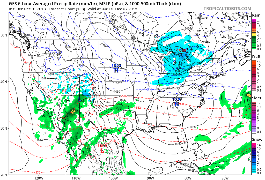 IV. That leads us to what comes next weekend. While it’s still far too early for any sort of specifics, we’ll simply say to keep a mental note in the back of your mind for the potential of a more disruptive winter event coming out from the southern Plains into the Ohio Valley. We’ll certainly have to fine tune things and “hone in” as we progress through the upcoming week. From this distance, prospects range from nothing more than a light snow to a “plowable” storm. Unlike this weekend’s storm, there will be a limit to how far north next weekend’s storm will be able to track…
Permanent link to this article: https://indywx.com/from-storms-to-snow-active-week-ahead/