Category: Summer
 Highlights:
- Feelin’ nice
- Scattered storms remain
- More widespread storms late week
Pleasant Open To The Work Week…A step out the door this morning will reveal a much more pleasant feel than what we’ve grown accustomed to over the past week, or so. Much lower humidity and cooler air will be with us through the day Tuesday. With that said, enough upper level energy will be nearby to spark afternoon and evening showers and embedded thundershowers both today and Tuesday.
Humidity will return for the midweek stretch, and temperatures will also be on the climb. While the weekend looks unsettled, the precise details remain a bit “murky” at this point. We know a cold front will slice into the warm and humid air mass, which will serve as a trigger for more widespread showers and thunderstorms (some with locally heavy rain). Some model guidance wants to get tropical moisture involved (from whatever comes of what’s currently Invest 93L). Stay tuned as we continue to look over the data this week. Regardless, a much cooler and drier air mass will arrive next week…
Upcoming 7-Day Precipitation Forecast:
- Snowfall: 0.00″
- Rainfall: 1.00″ – 1.50″
Permanent link to this article: https://indywx.com/2017/06/19/refreshing-open-to-the-week-scattered-storm-chances-remain/
I. Drier and Cooler Air Returns: A cold front will pass this evening and allow a much less humid and cooler air mass to return to the state. Dew points will fall into the 50s by Monday morning and highs should only reach the upper 70s to around 80 Monday afternoon. Refreshing air will remain in place through the day Tuesday.
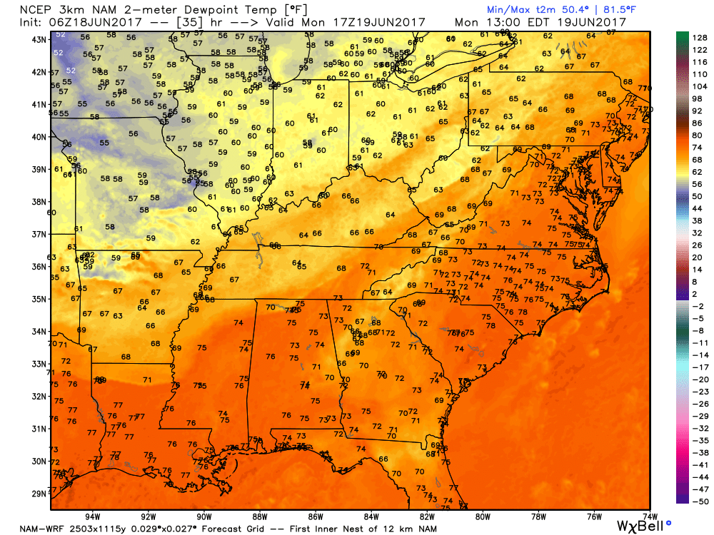
A much less humid air mass will arrive to open the work week.
II. Watching the Gulf: All eyes will be on the Gulf of Mexico this week as it tries to breed early season tropical “mischief.” There are many more questions than answers right now concerning the all-important details (ultimate track and strength), but confidence is high on a depression or storm forming in the Gulf by middle to latter portions of the week. Early thinking would place more emphasis on this being a big inland rain event across portions of the southeast, as opposed to this thing ramping up fast enough to be a big wind/ surge problem, but stay tuned.
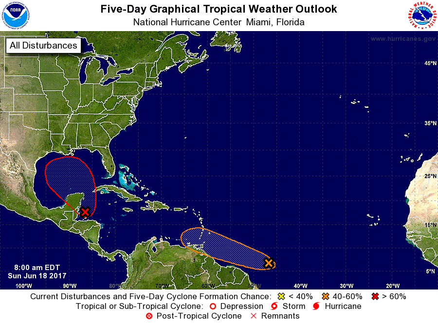
Confidence is high on early season tropical development this week in the Gulf of Mexico.
III. Unsettled Weather Returns: A storm system will approach the region by the latter portions of the work week, including the weekend. As a result, a warmer and increasingly moist air mass will return and help spawn showers and thunderstorms. Unfortunately, timing isn’t our friend as numerous showers and thunderstorms are forecast Friday-Sunday. Locally heavy rain is also a good bet.

Heavy rain and storm chances increase late week.
IV. June Ends On A Cool Note: Once we get rid of the significant storm next weekend, an unseasonably cool air mass will build in over the Great Lakes and Ohio Valley in the 8-10 day time period. How do highs in the upper 60s to lower 70s sound and lows in the middle 50s?
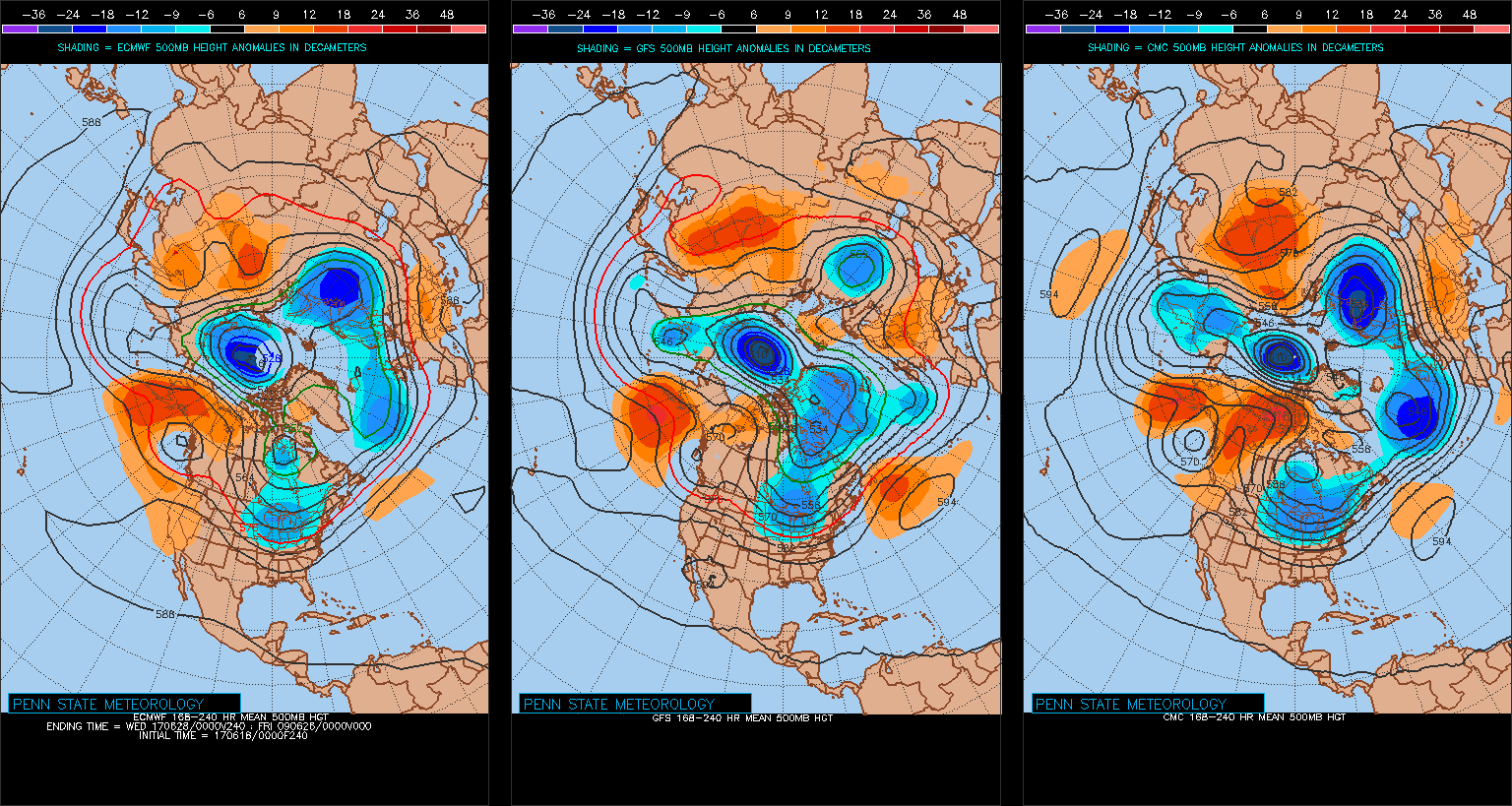
Models agree on an unseasonably cool close to June.
Permanent link to this article: https://indywx.com/2017/06/18/upcoming-week-headliners/
 Highlights:
- Strong storms late tonight
- Turning cooler and less humid
- Unsettled pattern back half of next week
Storms Rumble In Late Tonight…Most of the daytime today will be dry and hot. High humidity will also be with us and will help boost heat indices into the middle 90s. Take it easy outdoors today.
We’ll have to keep a close eye on radar trends upstream tonight as a complex of thunderstorms is expected to erupt to our northwest this evening. This storm complex will track southeast and begin impacting Indiana by late-evening (thinking around 11p, or so, across northwest portions of the state as of now). As we push into the overnight, these storms will continue to settle southeast, including central Indiana. A couple of these storms may be strong and with such high moisture content, locally heavy rainfall is, once again, a good bet.
A couple of showers or thunderstorms will be with us Father’s Day, but outdoor plans shouldn’t be cancelled, as most of the day appears to be dry. It’ll be a cooler day and less humid air will filter into the state Sunday night. This will produce a glorious open to the work week!
Unsettled weather will return by the middle and latter portions of next week, along with a briefly warmer and more humid feel.
Upcoming 7-Day Precipitation Forecast:
- Snowfall: 0.00″
- Rainfall: 1.50″ – 2.00″
Permanent link to this article: https://indywx.com/2017/06/17/tropical-feel-stormy-later-tonight/
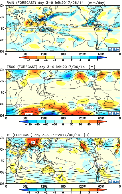
The new JMA Weeklies are in and highlighted by the following:
- Heat relief on the way through Week 1
- Core of heat, relative to normal, backs west through the period
- Active NW flow regime to open July
Week 1:
The JMA Weeklies really try to emphasize the “transient” nature of the pattern and associated dry, hot weather some folks were becoming concerned about only a couple of days ago. Week 1 is highlighted by a much wetter regime through the Ohio Valley and most of the East. As the ridge pulls back west, a cooler regime returns to our region, while the Southwest bakes with anomalously hot weather.
 Week 2:
The pattern favors wetter than normal conditions across the upper Mid West, including Great Lakes. The mean upper ridge is forecast to remain out west. Fittingly, the warmest temperatures, relative to average, will be confined to the west.
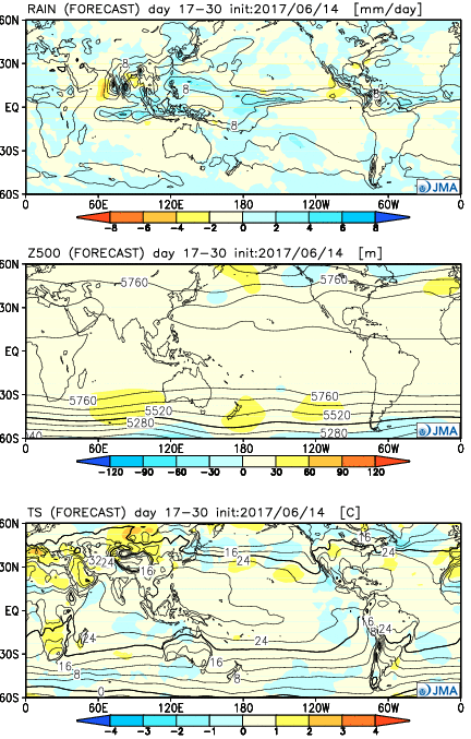
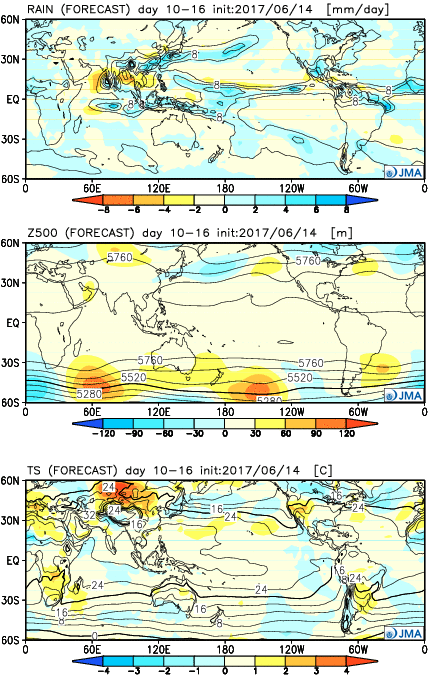 Weeks 3-4:
As we push into July, the upper pattern sets-up in a manner that will require us to keep a very close eye on storm potential. With a northwest flow aloft, we’ll have to be mindful of the potential of storm clusters impacting the region- tracking northwest to southeast. Through the balance of the period, the hottest weather should remain to our west, relative to normal.
Permanent link to this article: https://indywx.com/2017/06/15/jma-weeklies-heat-relief-coming-and-an-active-pattern-as-we-get-into-july/
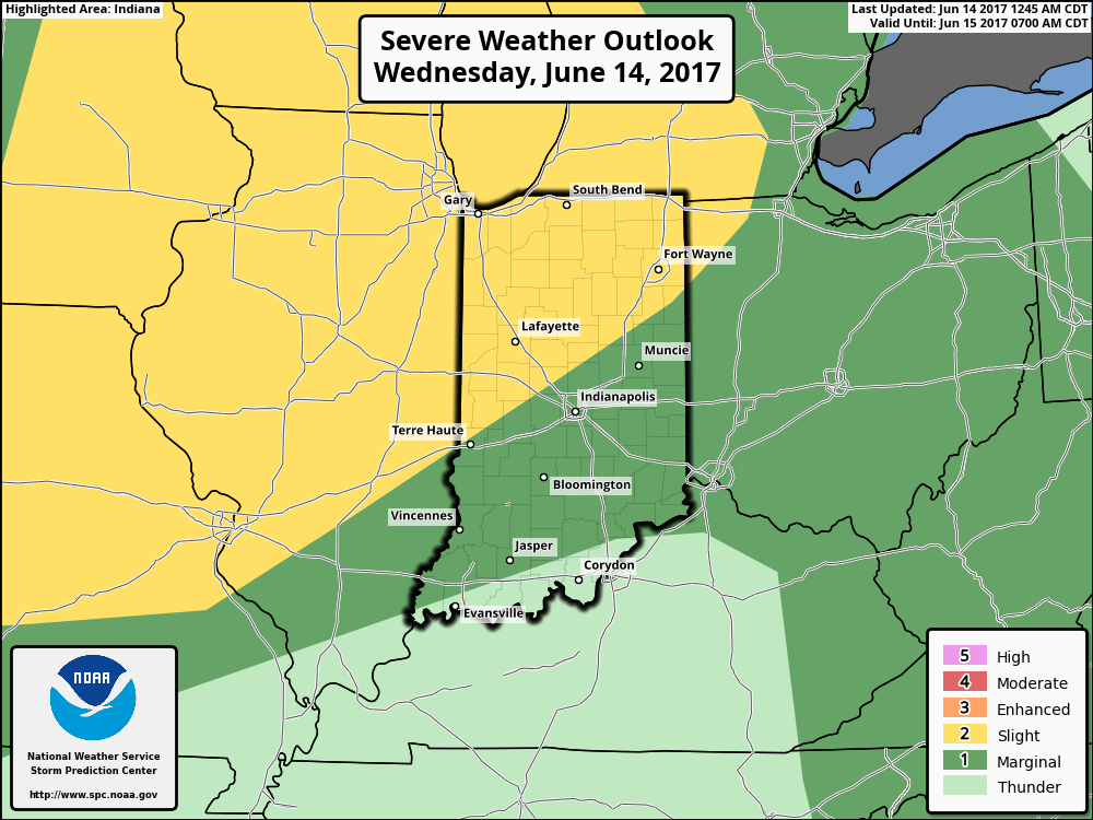
The Storm Prediction Center includes the northwestern portions of the state in a Slight Risk of severe weather later this afternoon and evening. Given the overall set-up and morning trends from data, it wouldn’t surprise us if this threat expands further southeast in future updates later today from the SPC.
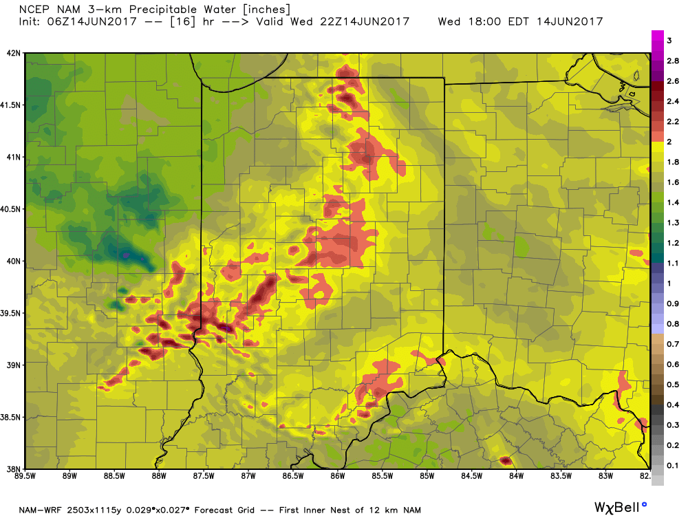
 Similar to Tuesday, any storms that develop will be capable of locally heavy rain and flash flooding. While storms should move in a quicker fashion today, precipitable water values (PWATs) remain downright tropical and will exceed 2″ later this afternoon.
 Overall storm coverage should become more widespread as we push into the afternoon and evening hours. Here’s what the radar may look like during the 4p, 6p, and 10p time frames:
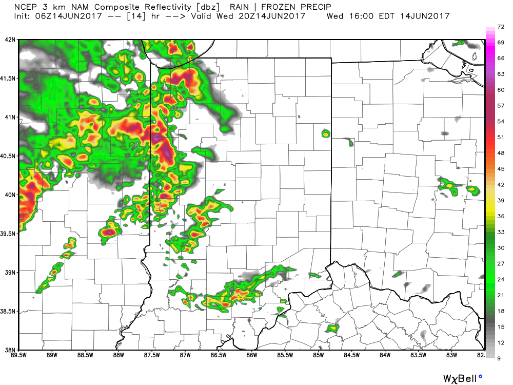
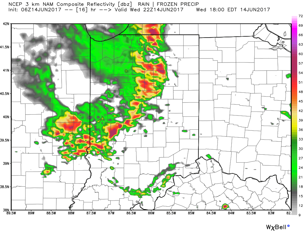
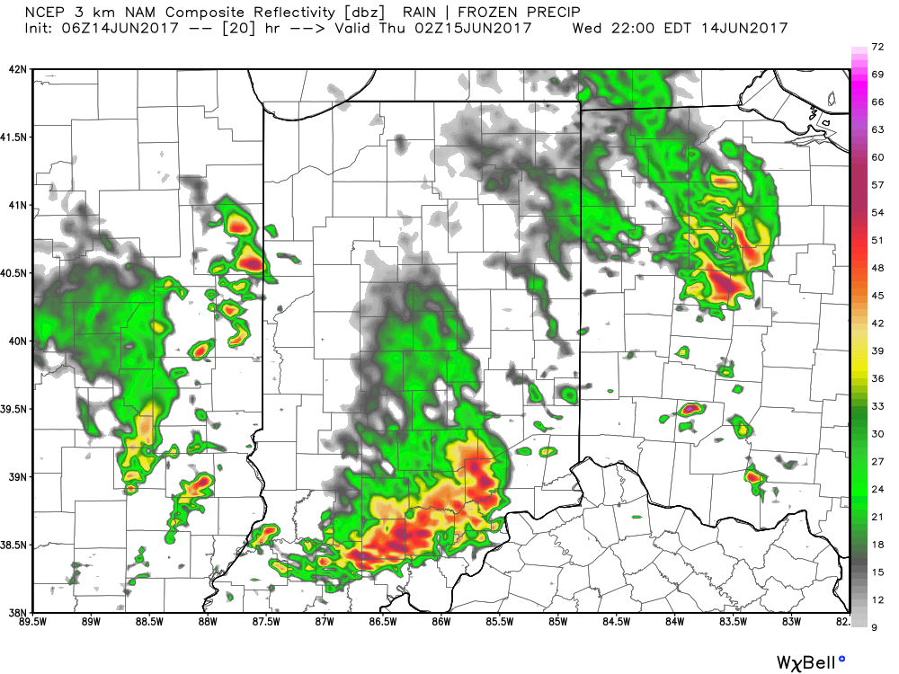 From a severe perspective, the biggest concern is damaging straight line winds with stronger storms. Remain weather-aware later today, friends!
Permanent link to this article: https://indywx.com/2017/06/14/another-stormy-day-ahead/
 Highlights:
- Scattered storms remain
- Oppressive feel
- Cooler times next week
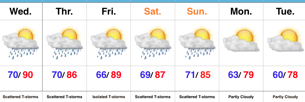
Locally Heavy Storms…We’ll remain locked into a very warm and moist air mass through the remainder of the week, but there’s light at the end of the tunnel. If you’re not a fan of the hot, humid weather, hang in there; next week will offer up a much different feel!
Before we discuss the cooler times that loom next week we still have to face several days of muggy weather and daily scattered storms. With such a “soupy” air mass in place (precipitable water exceeding 2″), any storms will be capable of producing torrential downpours. Similar to that of today, there will be “haves and have nots” over the next few days, but any storms that develop will have the potential of quickly pulsing to strong to severe levels and producing localized flash flooding.
Once to Sunday, a cold front will sweep through the state and finally wash all of the warm and humid air off to the southeast. While scattered storms will remain in our forecast through the weekend, a drier and cooler air mass will arrive on the scene early next week. Hang in there, friends!
Upcoming 7-Day Precipitation Forecast:
- Snowfall: 0.00″
- Rainfall: 1.00″ – 1.50″ (locally heavier totals)
Permanent link to this article: https://indywx.com/2017/06/13/soupy-now-but-changes-loom/
You must be logged in to view this content. Click Here to become a member of IndyWX.com for full access. Already a member of IndyWx.com All-Access? Log-in here.
Permanent link to this article: https://indywx.com/2017/06/13/video-hot-humid-weather-gives-way-to-better-storm-chances/
-
Filed under 10-day, AG Report, Auburn, European Model, Forecast Discussion, Forecast Models, GFS, Rain, Summer, T-storms, Weather Rambles
-
June 11, 2017
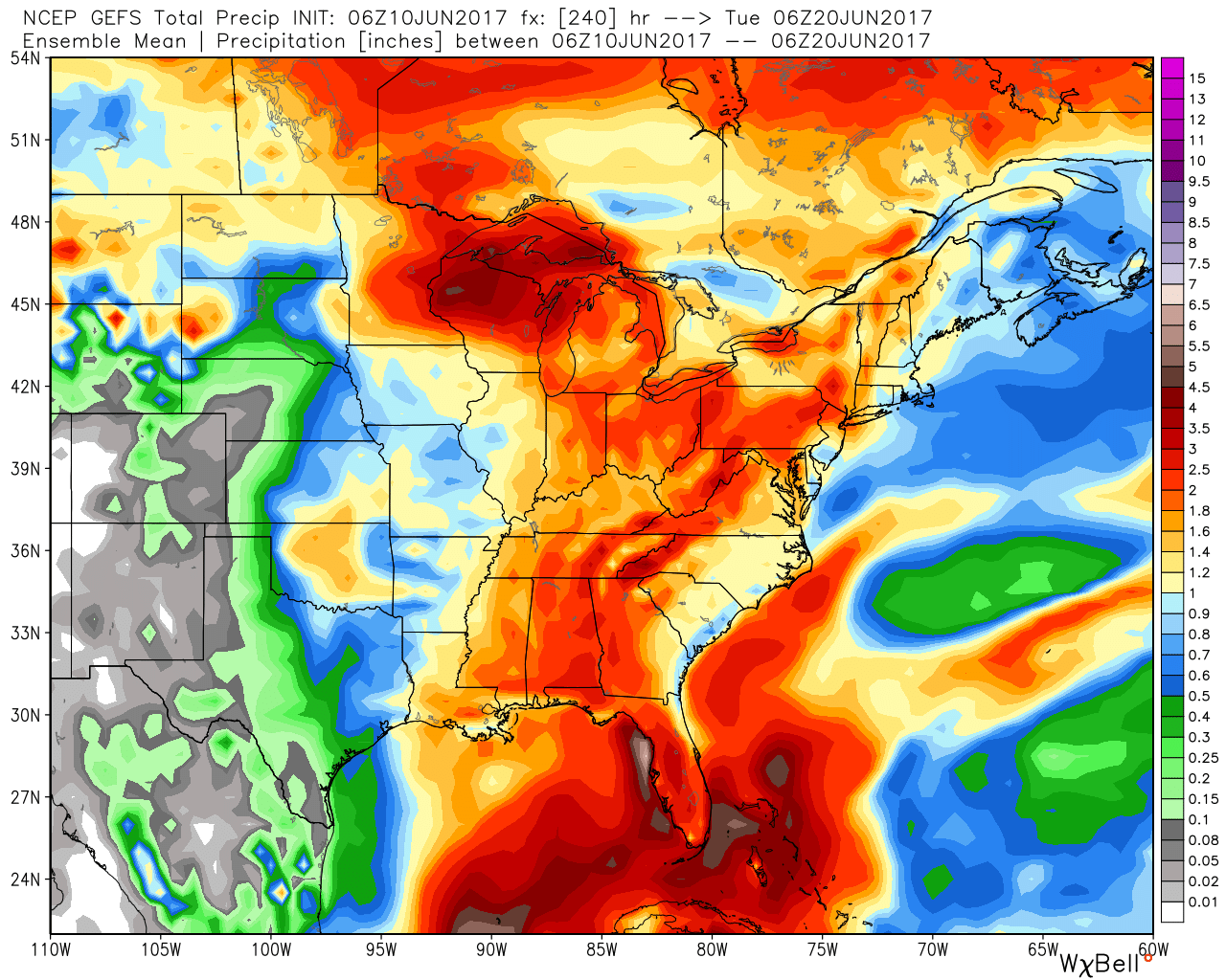
Today’s 12z model suite is in and it remains consistent on a more active weather pattern returning to the delight of many Hoosiers! A blend of the GFS and European 10-day rainfall numbers print out 2″ for Indianapolis. The GFS ensemble ‘mean’ (a blend of 21 individual members) agrees.
 Best overall coverage of showers and thunderstorms should come in (3) waves over the upcoming 10-day period:
- Wednesday into Thursday
- Saturday into Sunday
- Middle parts of the following week
While we don’t see any sort of uniform type rains in the upcoming period, the “smattering” of storms should help most neighborhoods get in on the rainy “goods” at one time or another over the upcoming week and a half. Keep in mind, we’re in mid-June now and it’s mighty difficult to ask for anything much more than scattered storms this time of year on through late-summer…unless a tropical entity gets involved. That’s just the way this time of year is. With that said, localized torrential downpours are a very good bet from time to time, beginning as early as mid-week, as precipitable water values approach, or exceed, 2″ (about as moisture-rich as you can ask the air mass to get around these parts) into the upcoming weekend.
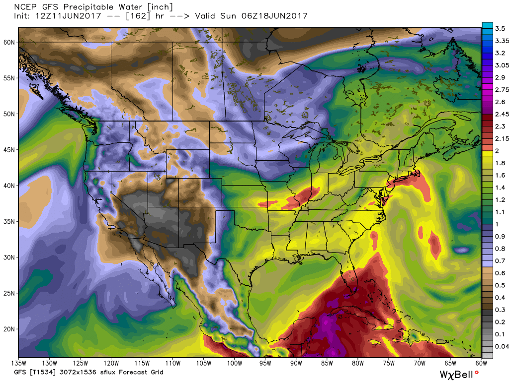 As I type this outside on the back porch this evening, I hear the sounds of sprinklers in full-force through the ‘hood. Thankfully, Mother Nature will help save on the water bill later this week. Longer-term, you’ll hear us use the word “transient” many times this summer when discussing the overall weather pattern. Thankfully that tends to result in a fairly busy time of things. Before you know it, college football season will be back (83 days until my beloved Auburn Tigers kick-off), those wetter autumn storms will return, and thoughts will begin to shift to winter (they may have already started here :-))- not that we’re trying to rush summer away or anything…
Permanent link to this article: https://indywx.com/2017/06/11/model-data-remains-consistent-on-a-more-active-pattern-returning/
 Highlights:
- Dry conditions continue
- Hot and turning humid
- Storm chances return
Tropical Feel Develops…Pleasant air is on borrowed time and we’ll begin to notice an increasingly muggy feel to the air as early as this afternoon. Dew points will reach oppressive levels Monday into Tuesday (70° and above). With the increased moisture, isolated thunderstorms will develop Tuesday, but most should still remain rain-free. Better shower and thunderstorm coverage will be noted Wednesday into Thursday as a frontal system moves through the state. This won’t be a “uniform” rain, but locally heavy downpours can be expected in the stronger storms. As dry as we’ve been, we’ll take what we can get. It’s a start, at the very least, towards a more active second half of June.
We’ll dry things out briefly Friday before another storm system approaches next weekend. Early indications would suggest next weekend’s storm system will provide more widespread shower and thunderstorm activity.
Tropics: Interesting times appear to be looming in the Gulf of Mexico as we push into the last couple weeks of the month. Models continue to paint various scenarios on potential early season tropical development and any one solution can’t be bought just yet. That said, the overall pattern does seem to want to promote some tropical “mischief” in the coming 10 days, or so.
Upcoming 7-Day Precipitation Forecast:
- Snowfall: 0.00″
- Rainfall: 0.75″ – 1.00″
Permanent link to this article: https://indywx.com/2017/06/11/hot-and-humid-storms-chances-return/
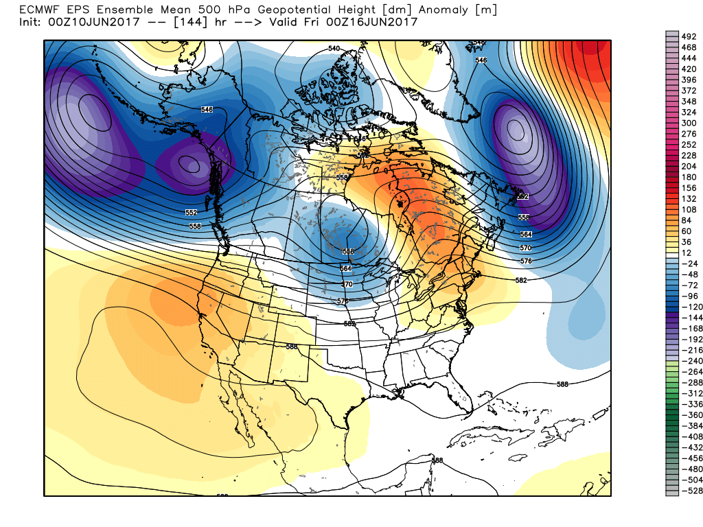
Through the short-term, there are two words that will sum up Indiana’s weather: Dry and Hot. We’re entering a stretch where the overall weather pattern will promote an expanding hot dome in the coming days, and put many communities across the state solidly in position to break the 90° mark on multiple days.

Expanding upper ridge means hot times loom late weekend into early next week.
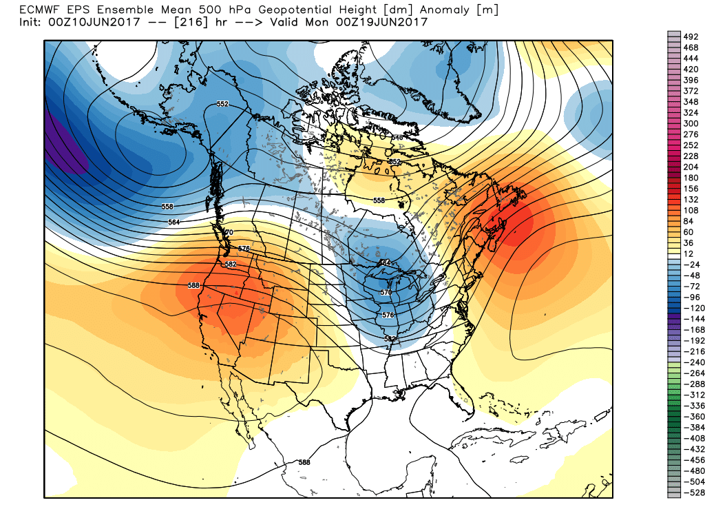
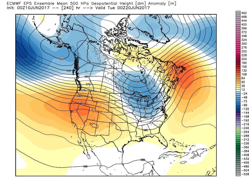
However, this increasingly hot and dry pattern will be a transient one. This morning’s European model shows the evolution to cooler and increasingly wet, unsettled times nicely as we progress into the 6-10 day period.


The GFS ensemble would also agree in the overall pattern shift back to cooler and unsettled conditions as early as mid-late next week.

The 10-day GEFS ‘mean’ is a beautiful sight as moisture returns.
Updated 7-day out later this afternoon! Enjoy a beautiful Saturday, friends!
Permanent link to this article: https://indywx.com/2017/06/10/developing-hot-pattern-doesnt-last-cooler-and-wetter-times-loom/
 Highlights:


 Highlights:
 Week 2:
  Weeks 3-4:
 Similar to Tuesday, any storms that develop will be capable of locally heavy rain and flash flooding. While storms should move in a quicker fashion today, precipitable water values (PWATs) remain downright tropical and will exceed 2″ later this afternoon.
 Overall storm coverage should become more widespread as we push into the afternoon and evening hours. Here’s what the radar may look like during the 4p, 6p, and 10p time frames:

 From a severe perspective, the biggest concern is damaging straight line winds with stronger storms. Remain weather-aware later today, friends!
 Highlights:
 Best overall coverage of showers and thunderstorms should come in (3) waves over the upcoming 10-day period:
 As I type this outside on the back porch this evening, I hear the sounds of sprinklers in full-force through the ‘hood. Thankfully, Mother Nature will help save on the water bill later this week. Longer-term, you’ll hear us use the word “transient” many times this summer when discussing the overall weather pattern. Thankfully that tends to result in a fairly busy time of things. Before you know it, college football season will be back (83 days until my beloved Auburn Tigers kick-off), those wetter autumn storms will return, and thoughts will begin to shift to winter (they may have already started here :-))- not that we’re trying to rush summer away or anything…
 Highlights:
