Category: Summer
|
Mon.
|
Tue.
|
Wed.
|
Thr.
|
Fri.
|
Sat.
|
Sun.
|
|

|
|

|
|
|
|
|
|
68/ 88
|
69/ 81
|
66/ 82
|
61/ 84
|
65/ 83
|
68/ 84
|
70/ 87
|
|
Light
|
Light
|
– – –
|
– – –
|
Light
|
Light
|
Light
|
We’re going to open another work week with a similar weather theme- warm and humid with scattered afternoon showers and thunderstorms. Best rain chances will arrive after 2 to 3 o’clock and localized torrential downpours are a good bet. While everyone won’t see impressive rainfall totals, those that get caught under a stronger storm can expect a quick 1″ of rain. Overall coverage of showers and thunderstorms will likely grow Tuesday, but we still don’t think we’re looking at an all day rain and some sunshine can be expected in between showers and storms. We’ll enjoy a couple of drier days Wednesday and Thursday along with slightly cooler temperatures before we heat things back up and introduce rain chances heading into your weekend.
Are your or your business interested in personal weather consulting or mid and long range ag forecasts? Email us: bill@indywx.com.
Permanent link to this article: https://indywx.com/splash-and-dash-storms-to-open-the-work-week/
|
Sun.
|
Mon.
|
Tue.
|
Wed.
|
Thr.
|
Fri.
|
Sat.
|
|
|
|

|
|
|
|
|
|
63/ 85
|
66/ 87
|
69/ 80
|
65/ 83
|
63/ 83
|
69/ 80
|
66/ 83
|
|
Light
|
Light
|
Moderate
|
Light
|
Light
|
Moderate
|
Light
|
Though we officially just welcomed in summer, we’ve been in meteorological summer since June 1st. The meteorological seasons include June through August for summer, September through November for fall, December through February for winter, and March through May for spring. This week we’ll feel very much like summer, including seasonable temperatures and plenty of rain and storm chances! Coverage of those showers and thunderstorms will be widely scattered today and Monday, primarily during the afternoon and evening hours. While everyone won’t get wet, some locally heavy downpours are possible. Looking ahead, we target better chances of more widespread showers and thunderstorms Tuesday and again Friday. The week ahead stands to be another wet one on the precipitation front, including widespread 1.5″-2″ totals during the course of the upcoming 7 days on average.
Permanent link to this article: https://indywx.com/feeling-like-summer-2/
-
Filed under 7-Day Outlook, Forecast, Forecast Discussion, Forecast Models, GFS, Heavy Rain, Rain, Severe Weather, Summer, T-storms
-
June 19, 2014
Thr. Fri. Sat. Sun. Mon. Tue. Wed. 70/ 87 69/ 84 66/ 85 64/ 86 66/ 89 66/ 80 66/ 78 Light Light…
You must be logged in to view this content. Click Here to become a member of IndyWX.com for full access. Already a member of IndyWx.com All-Access? Log-in here.
Permanent link to this article: https://indywx.com/remaining-active/
-
Filed under 7-Day Outlook, Forecast, Forecast Discussion, Hail, Heavy Rain, NAM Model, Rain, Severe Weather, Summer, T-storms, Unseasonably Warm, Weather Videos, Windy
-
June 17, 2014
Good afternoon! We wanted to cut a video discussing our thinking around timing and primary threats from any severe weather that gets going across central Indiana tomorrow evening.
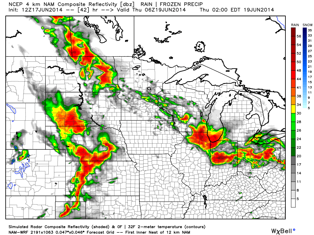
4km NAM forecast radar suggests a stormy time of things Wednesday evening. We discuss in your afternoon video update!
Permanent link to this article: https://indywx.com/focusing-on-wednesday-evening-severe-potential/
Tue. Wed. Thr. Fri. Sat. Sun. Mon. 70/ 90 71/ 89 71/ 89 70/ 86 70/ 86 70/ 84 67/ 80 – –…
You must be logged in to view this content. Click Here to become a member of IndyWX.com for full access. Already a member of IndyWx.com All-Access? Log-in here.
Permanent link to this article: https://indywx.com/hot-and-humid/
