VIDEO: Unsettled Now, But A Beautiful 2nd Half Of The Weekend Ahead…
You must be logged in to view this content. Click Here to become a member of IndyWX.com for full access. Already a member of IndyWx.com All-Access? Log-in here.
You must be logged in to view this content. Click Here to become a member of IndyWX.com for full access. Already a member of IndyWx.com All-Access? Log-in here.
Central IN is still in play for a multi-day heavy rain event that begins this weekend and continues into the middle of next week.
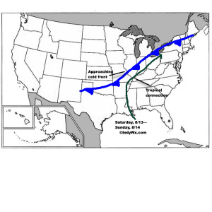
The setup is still one that features a wavy cold front that will halt to a crawl (eventually becoming stationary) over central and southern IN over the weekend. Additionally, tropical moisture will continue to slowly push north, before curling northeast (following the frontal boundary) into the Ohio Valley. The image below from Monday displays the setup nicely.
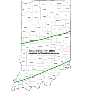
 Despite lackluster model output from our American suite (latest NAM and SREF data, for instance, paints rainfall totals under 1″ across most central IN neighborhoods), the European remains consistent on the evolution of things from this weekend into the middle of next week. We’ll lean more towards it’s solution at this juncture. Simply put, when you have a stalled frontal boundary entraining tropical moisture, expect problems. Precipitable water values will approach and even exceed 2″ at times this weekend. Dew points will remain in the upper 60s to lower 70s along and south of the boundary. Where the boundary stalls will be key in determining the heaviest rain totals and resulting flood problems that will ensue. For now, here’s the best idea we have in regards to local 4″+ totals between this weekend and next Wednesday.
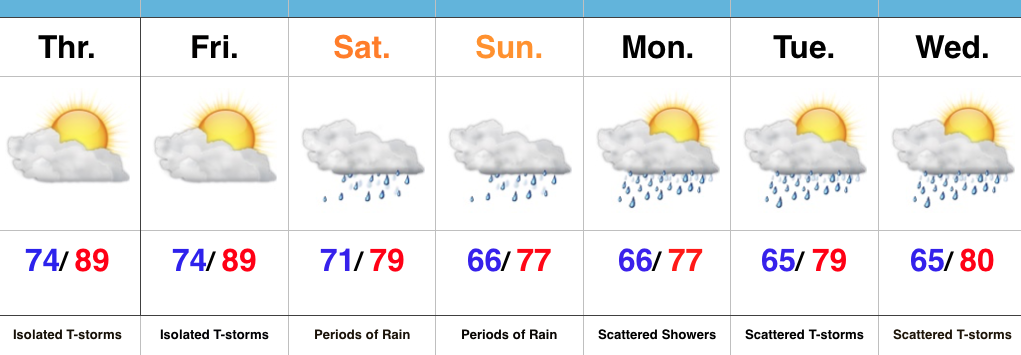
 It should also be pointed out that we’re not looking at all day rains Saturday through Wednesday, but instead “waves” of moisture throughout the period. Areas of locally heavy rain will be with us, but we’ll also see dry periods in between. Thankfully, as we move into the latter portions of next week, drier times should return.
We’ll be here through the weekend to keep you updated on things, as well as on social media. Stay tuned.
 Highlights:
Zoning In On Heaviest Rains…It’s about as humid as it can get across central IN. “Air you can wear” is the appropriate way to describe this humidity and overall sultry feel. As we’d expect with this tropical air mass, isolated to widely scattered strong storms could pop at any point and result in locally heavy rain. We’ll “rinse and repeat” today’s forecast to wrap up the work week.
Attention then shifts to a widespread soaking rain event this weekend as two main players “team up” to produce a localized flood threat. A cold front will sag into central IN while remnant tropical moisture slowly moves north and eventually curls northeast. Precisely where the front stalls in response to the tropical low moving north will be where heaviest (4″+) rains set up. Thinking this morning places the greatest risk somewhere between Indianapolis and Louisville, but we caution that we still want to see a couple more model runs before settling on a given area. Unsettled weather will likely continue into early next week as tropical moisture slowly exits stage right.
Longer term, indications point towards an overall cooler, wetter, back half of August. Times- they are ‘a changing!
Upcoming 7-Day Precipitation Forecast:
You must be logged in to view this content. Click Here to become a member of IndyWX.com for full access. Already a member of IndyWx.com All-Access? Log-in here.
You must be logged in to view this content. Click Here to become a member of IndyWX.com for full access. Already a member of IndyWx.com All-Access? Log-in here.