 Highlights:
- Spring-like weather rolls along
- Shower chances return
- Strong t-storm potential
- Different tune next weekend
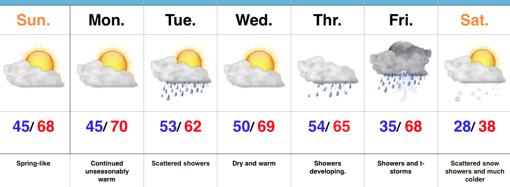
Is This February? Our stretch of unseasonably pleasant, spring-like, weather will continue for the second half of the weekend and as we progress into the early stages of the work week. Find a way to get outside the next couple of days (that’s an order ;-)).
A weak weather system will scoot through here Tuesday and serve to increase our cloud cover, along with a few scattered showers. Dry conditions return Wednesday, but by then all eyes will be on an approaching stronger storm system that will provide increased shower coverage by Thursday and strong to severe thunderstorm potential Friday. Speaking of severe weather, we think this spring will offer up a busy severe weather season. We’ll have additional updates on the severe potential as time gets closer, but just keep a mental note Friday could be a busy weather day.
We’ll abruptly transition back to winter Friday night and the air will grow cold enough a week from today to allow scattered snow showers to fly in a gusty northwesterly breeze next Saturday.
Upcoming 7-Day Precipitation Forecast:
- Snowfall: Trace – Dusting
- Rainfall: 0.50″ – 1.00″
 Highlights:


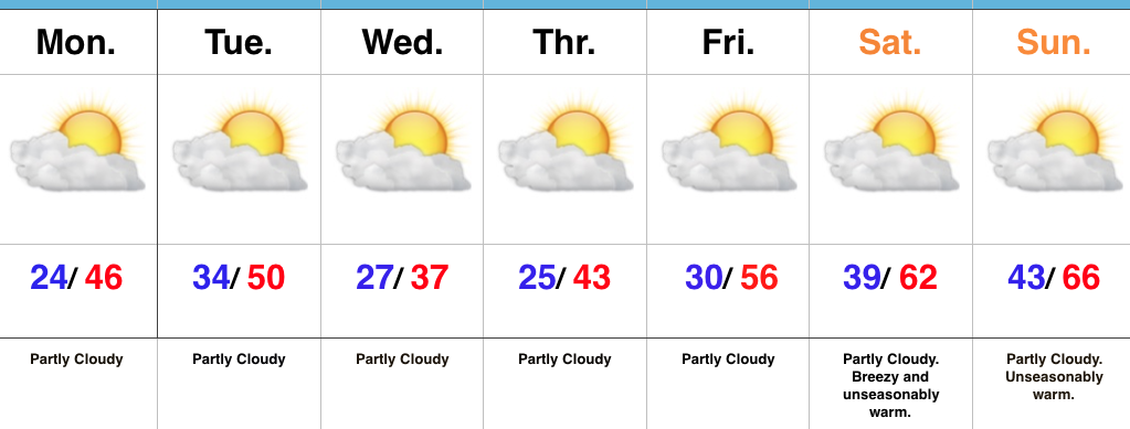
 2.) What at one time looked to be a significant weekend storm now may not even deliver any precipitation at all to the region. A flurry is possible, but most should remain precipitation-free this weekend. Expect a gusty southwest wind developing SB Sunday. Highs around freezing Saturday will zoom into the middle 40s Sunday. Lows Saturday morning in the middle 10s will rise into the upper 20s to around 30 Sunday morning.
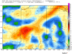
 3.) A more significant storm system will cut for the Great Lakes early next week and this will deliver gusty showers and embedded thunderstorms. A couple of stronger storms aren’t out of the question. Locally heavy rains can be expected, including amounts of 1″-1.5″ (locally heavier totals).
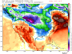
 4.) Cold air will rush back into the region behind the storm and snow showers and squalls are likely by Wednesday.
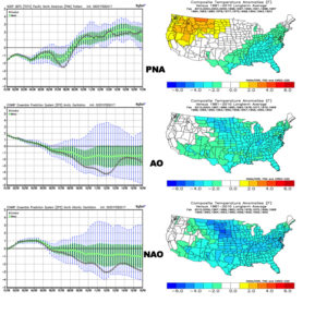
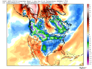
 5.) Longer-term, a real fight is developing on the overall direction we’re heading as February evolves. Analog methods and teleconnections (shown below) would yield bullish cold signals and give hope to winter enthusiasts. However, modeling isn’t in agreement on the wintry ideas. In fact, some modeling is very spring-like as mid-Feb nears. Stay tuned as we try and iron out the details this weekend. Updates will come.