
You must be logged in to view this content. Click Here to become a member of IndyWX.com for full access. Already a member of IndyWx.com All-Access? Log-in here.
Category: Spring
Permanent link to this article: https://indywx.com/video-heavy-wet-snow-arrives-before-sunset/
Mar 31
I’m Dreaming Of A White…Easter?
A cold front will blow through central Indiana this evening and colder air will spill into the region overnight. We’ll wake up with temperatures in the upper 20s to lower 30s Easter morning with dry conditions in place.
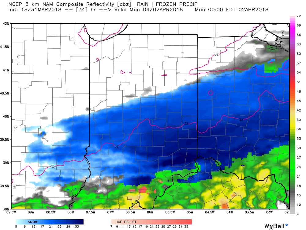
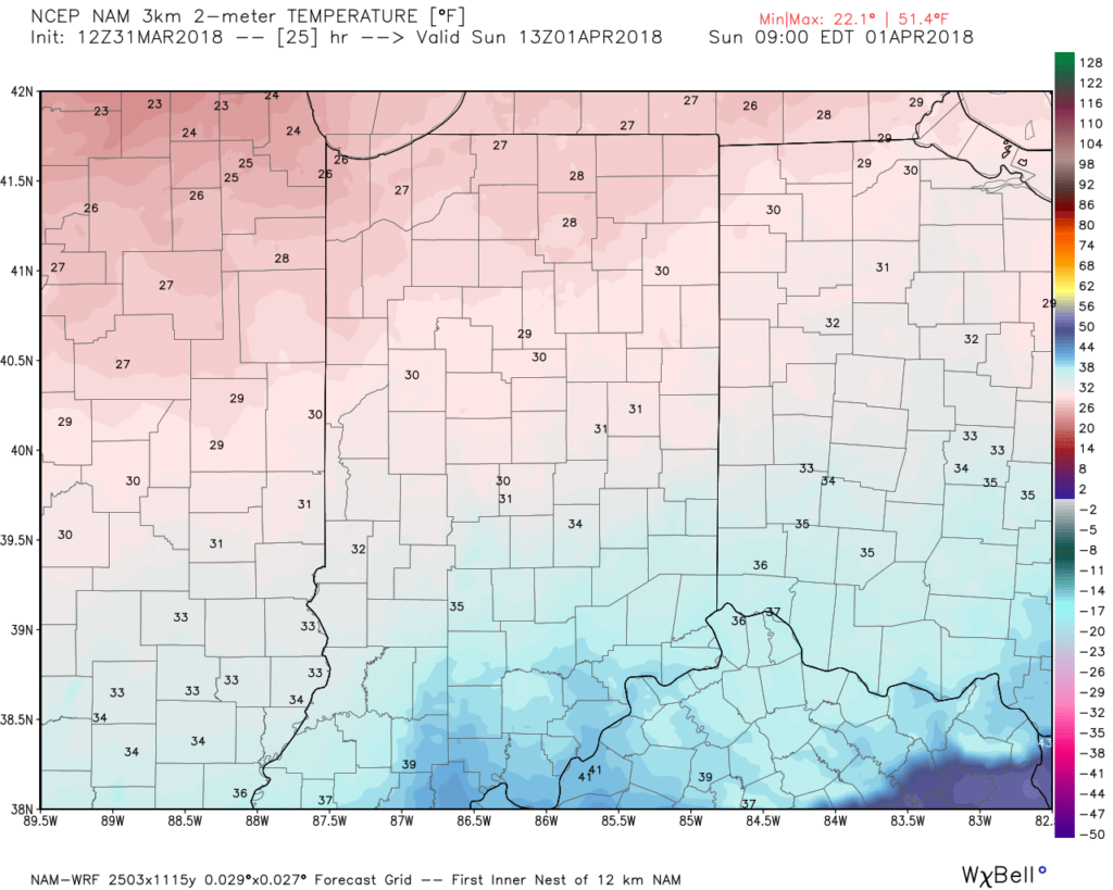 Most of the daytime Easter Sunday will feature dry conditions. Clouds will increase, lower, and thicken through the afternoon ahead of an area of low pressure that will track through the lower Ohio Valley Easter night. This will spread precipitation into central Indiana towards 5p-6p. Initially, precipitation is likely to begin as a cold rain, but we expect a rather quick transition to wet snow shortly after the onset. Periods of moderate to heavy snow will fall into the nighttime across the I-70 corridor. This will lead to reduced visibility and slick travel as snowfall rates will (once again) overcome marginally cold surface and pavement temperatures. If you must travel tomorrow night and early Monday, expect roadways to be slick at times- including being slush and snow covered.
Here’s an idea of what the radar may look like tomorrow night, courtesy of weatherbell.com:
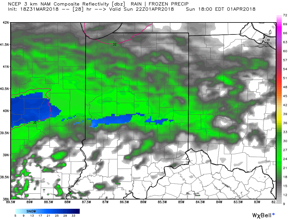
6p forecast radar
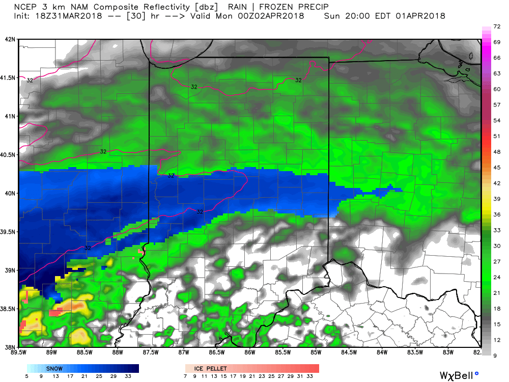
8p forecast radar
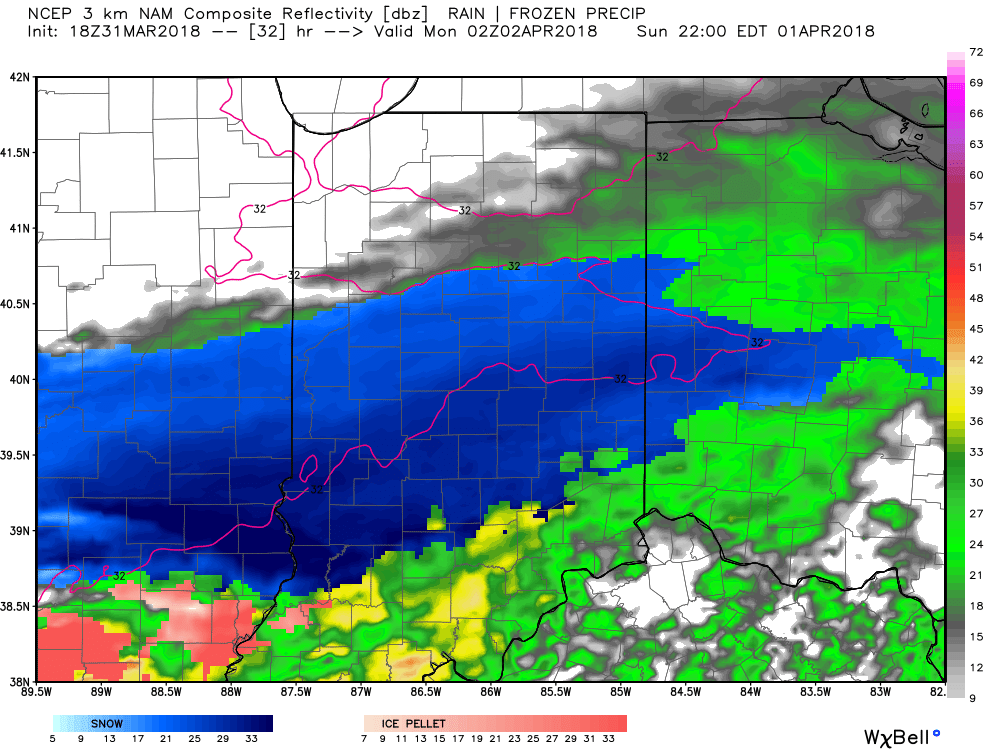
10p forecast radar
12a forecast radar Monday
This will be a rather quick-hitting event, but “thump” potential is written all over it, including localized intense banding. These localized bands could result in a couple of reports of 4″+ in spots. We think heaviest snow falls in the 6p-midnight window.
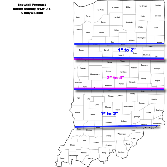
Our current snowfall forecast:
 Another winter event is possible next weekend, including the potential of additional accumulating snow. Should we get snow down, the possibility of near-record cold is present with the late season blast of arctic air next weekend. Lows in the 10s aren’t out of the question at least one night next weekend- likely Sunday.
Permanent link to this article: https://indywx.com/im-dreaming-of-a-white-easter/
Mar 11
Week Ahead: Cold Open Gives Way To Warmer Air In Time For St. Patrick’s Day…
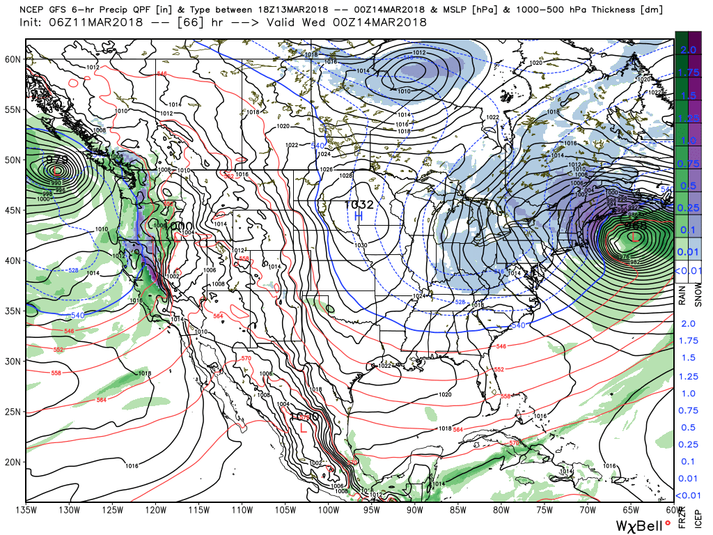
A storm system will gather strength to our south as we progress through the day and into the night. While central Indiana won’t experience significant impacts from this storm, we’ll indirectly deal with this system with considerable cloudiness and a chilly easterly breeze today.
Our friends to our south (KY and the higher elevations of the southern Appalachians) can expect accumulating snow. The east TN and western NC mountains will accumulate over 6″ above 5,000 feet late tonight through Monday morning.
 The region will be under the grips of a cold northerly flow through the first half of the work week. Embedded within that air flow will be a couple of upper level disturbances that will drop into the Ohio Valley. These impulses of energy will help kick off snow showers and localized heavier squalls at times Monday through Wednesday. Some localized accumulations of a dusting to 1″ will be possible.
 High pressure will gain control of our weather Thursday and this will include the start of a nice moderating trend for the second half of the week, including the St. Patrick’s Day weekend. With full sunshine Thursday, along with WAA (warm air advection) kicking in, we think highs will top out much warmer than the majority of current guidance suggests. We’ll go with widespread mid to upper 50s Thursday.
 Unfortunately, we’ll add more clouds and showers next weekend. Wet weather will build in Friday and we can’t rule out shower chances Saturday, as well. Temperatures will warm well into the 60s by St. Patrick’s Day!

 In general, we expect 0.25″ to 0.50″ across central IN with showers in the Friday-Saturday time period.
Permanent link to this article: https://indywx.com/week-ahead-cold-open-gives-way-to-warmer-air-in-time-for-st-patricks-day/
Mar 10
VIDEO: Saturday Morning Thoughts On Late March…
In the midst of trying to keep Bo, our youngest golden doodle, from becoming a tremendous distraction in this morning’s video, here are some thoughts on what lies ahead over…
You must be logged in to view this content. Click Here to become a member of IndyWX.com for full access. Already a member of IndyWx.com All-Access? Log-in here.
Permanent link to this article: https://indywx.com/video-saturday-morning-thoughts-on-late-march/
Mar 09
VIDEO: Weekend And Beyond…
You must be logged in to view this content. Click Here to become a member of IndyWX.com for full access. Already a member of IndyWx.com All-Access? Log-in here.
Permanent link to this article: https://indywx.com/video-weekend-and-beyond/