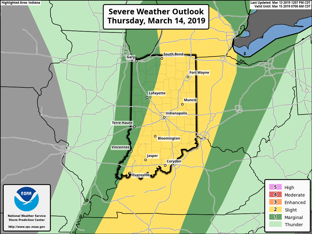
Significant weather alert day across central IN, including damaging wind potential and severe thunderstorms…
You must be logged in to view this content. Click Here to become a member of IndyWX.com for full access. Already a member of IndyWx.com All-Access? Log-in here.
What: All modes of severe weather, including tornadic potential. Damaging wind gusts.
When: Damaging wind gusts develop late tonight into the predawn Thursday. Severe storms are most likely Thursday afternoon into early Thursday evening.
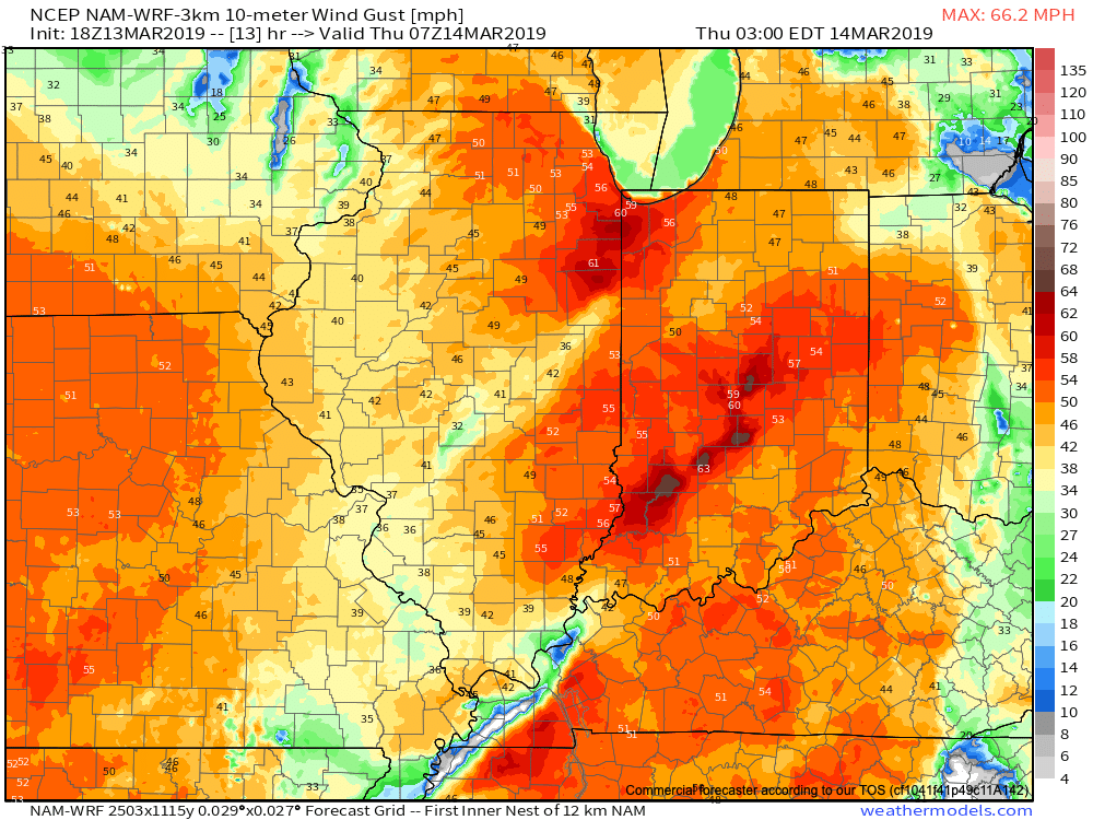
Wind: SW 45-55 MPH with gusts of 60 MPH+
Winds will begin to gust to potentially damaging levels during the overnight tonight.
A couple of rounds of thunderstorms will impact central Indiana during the overnight and again Thursday afternoon and evening. It’s the second round tomorrow afternoon that has us most concerned for the potential of strong to severe thunderstorms. A lot of this hinges on just how much clearing takes place from the morning round of showers and embedded thunder. Should we clear things out in significant fashion, and introduce some sunshine, the threat of severe weather tomorrow afternoon will grow significantly. Conversely, should we hold onto a mostly overcast sky, this will limit the overall severity of afternoon storms. The sun would help destabilize things in rather rapid fashion and given some of the other parameters in place, would lead to all modes of severe weather with storms that develop tomorrow afternoon- including large hail and tornadoes.
Additionally, due to the sheer strength of the storm system, damaging winds are still in play tomorrow (even outside of thunderstorms). In fact, winds will begin to gust upwards of 50 MPH+ during the overnight period tonight. If you haven’t already, please take the time now to tie down or secure loose objects to keep them from being blown about in the wind.
Conditions will begin to improve as early as tomorrow night, although we’ll turn much colder. Air will grow cold enough to promote “wrap around” moisture to fall in the form of snow by Friday afternoon.
Threat of strong to severe storms will be greatest Thursday afternoon into the early evening hours.
Concern is growing for the potential of severe weather Thursday. A strong and potentially damaging wind event is still on the table Wednesday night through Thursday, as well…
You must be logged in to view this content. Click Here to become a member of IndyWX.com for full access. Already a member of IndyWx.com All-Access? Log-in here.
Strong winds and the potential of strong storms loom Thursday. We look in more detail at these threats and ahead to the pattern for late March and into April…
You must be logged in to view this content. Click Here to become a member of IndyWX.com for full access. Already a member of IndyWx.com All-Access? Log-in here.
After a cold open to March, a taste of spring will develop this week as temperatures go into the 50s Tuesday, 60s Wednesday, and 70s (not a typo) for the first time this year on Thursday. Unfortunately, this spring preview will be joined by a strong and potentially damaging wind event Thursday.
A combination of ingredients has us particularly concerned in advance of this event:
A well mixed airmass
Lapse rates exceeding 8 deg or higher C/Km- enabling easier access to the high winds aloft (you can read more about this here if curious)
Dry slot after Wednesday showers and Thursday evening rain
Accordingly, the potential of 60 MPH + gusts are possible Thursday and we’d expect the National Weather Service to eventually have to issue high wind products as we get closer. These are the type gusts that will lead to downed trees and scattered power outages.
Already, modeling is producing ominous signals for very high and potentially damaging gusts out of the southwest Thursday. Stay tuned, friends.