Keeping An Eye On The Weekend…

Forecast models have been printing out wintry solutions for the upcoming weekend- particularly Saturday night through Super Bowl Sunday.

The GFS 500mb charts between 12z Monday and this morning show the key with this potential storm.  Note the difference between yesterday (top) and today (bottom).  The GFS model brings more energy out and the result is a stronger storm system.

SunGFS5001


GFSSun5002Timing between cold and moisture associated with storm systems has been the important missing link this winter with bigger storms.  Does that trend continue this weekend?  Snow lovers hope not…

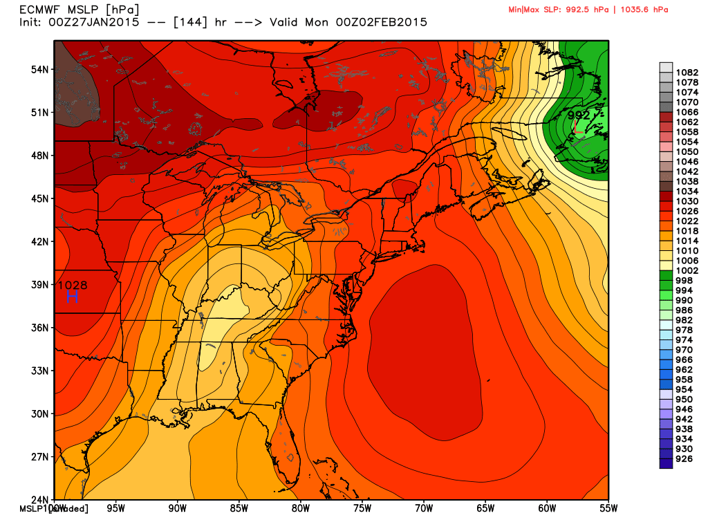
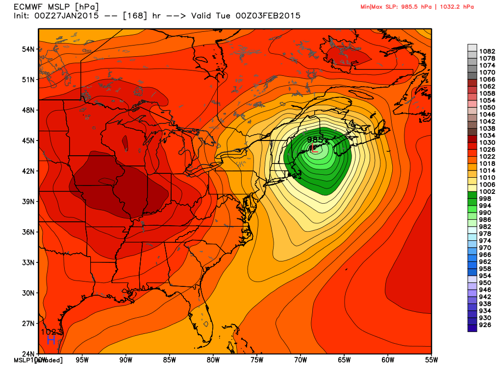
A key ingredient that has been missing in the past is a big area of high pressure north of the region supplying cold air as surface low pressure tracks in a favorable position for wintry precipitation.  Models do suggest not only renewed arctic high pressure building down the Plains region Sunday into Monday, but also a 1040mb high over the northern Lakes region.  This would help go a long way in keeping cold air flowing into the region.

What about the sensible weather here?!  Keeping in mind that this is still an event 5 days out…..  The GFS model suggests mostly a snow event north-central, but also brings in a wintry mix of icy precipitation and rain across the southern half of the state.  The Canadian forecast model (not shown here) is more suppressed and leads to an accumulating weekend snow event across the region and targets southern portions of the state for heaviest snowfall.  The European model is the most “ideal” scenario for central Indiana snow lovers and leads to a significant snow event across the heart of the state.

Note the European forecast model track a wave of low pressure in an ideal location for heavy snow across central Indiana before intensifying and hammering the Northeast region.
ecm_mslp_east_7


ecm_mslp_east_8

We’ll continue to keep a close eye on this developing situation. Stay tuned….

Light Snow Impacts Some This Evening…

Screen Shot 2015-01-26 at 7.44.39 AMSlick Travel This Morning; More Light Snow This Evening…Rain changed to snow in and around Indianapolis between 5-6 Sunday evening.  The changeover occurred earlier just north and northeast of the city where anywhere from a quarter inch of snow fell to as much as 3 inches in and around the Muncie area.  The big problem last night and this morning is the combination of moisture freezing on the roadways, light snow, and strong and gusty winds.  Area roadways have been reported slick with numerous accidents.  Take it slow this morning.

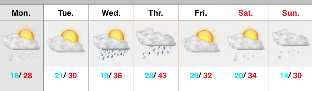
Most of today will be quiet and dry, but light snow will build into the state later this evening into tonight.  We target areas along and west of I-65 for the greatest opportunity of accumulating a dusting to half an inch of snow tonight.  Sunshine returns Tuesday before a mid week system brings light rain Wednesday night into Thursday.  Light rain will diminish as light snow Thursday.

Colder air will be with us as we wrap up the work week before our next storm system impacts the Hoosier state over Super Bowl weekend.  We forecast increasing clouds Saturday with snow developing Saturday night into Sunday.

Upcoming Precipitation Forecast:

  • 7-Day Rainfall Forecast: 0.10″ – 0.25″
  • 7-Day Snowfall Forecast: 2″ – 4″

A Word Of Thanks…

First, I just want to take a moment to thank each and every one of our viewers.  Your support of what we’re doing here is incredible and, at times, truly…

You must be logged in to view this content. Click Here to become a member of IndyWX.com for full access.  Already a member of IndyWx.com All-Access?  Log-in here.

Tough Forecast Today…

Screen Shot 2015-01-25 at 9.04.28 AMHigh Bust Potential Today…Clippers are always tough to forecast, but particularly so today.  This is a vigorous system and while temperatures will only be marginally cold, the concern here is that precipitation rates may help cool the entire column of air a bit quicker this afternoon than modeling currently suggests.  If (big if) that’s the case, then snowfall amounts below would have to be increased.  As it is now, we feel about as confident as we can be right now that the “slimmed” down numbers below will suffice.  As has been the case with a couple of other events this winter, it’ll be a nowcast scenario this afternoon.  Winds will also become quite gusty out of the east and northeast this afternoon into tonight.

Colder, drier air builds in late tonight and Monday before a weak weather system scoots through and delivers light snow showers Tuesday.  A wintry mix is possible Thursday and then we’ll eye late next weekend for the next snow opportunity.

Upcoming 7-Day Precipitation Forecast:

  • 7-Day Snowfall Forecast: 2″ – 4″
  • 7-Day Rainfall Forecast: 0.50″

12515SnowfallMapV2