Category: snow

Busy Weather Week Next Week…

After a relatively quiet week of weather around these parts, next week promises to be different.  We’ll deal with showers and thunderstorms Wednesday into Thursday. Heavy rain will be possible…

You must be logged in to view this content. Click Here to become a member of IndyWX.com for full access.  Already a member of IndyWx.com All-Access?  Log-in here.

Permanent link to this article: https://indywx.com/busy-weather-week-next-week/

3/18/15 Ag Weather Report

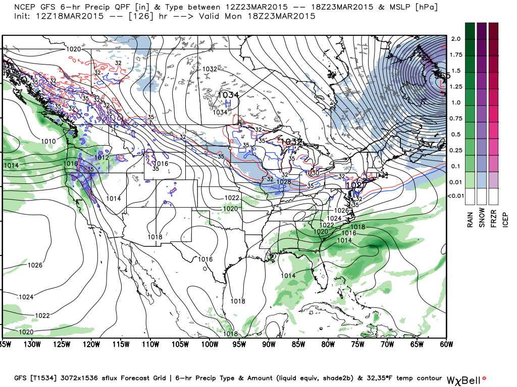
A weak weather maker will impact Indiana and the Ohio Valley Thursday, especially during the afternoon into the overnight. Precipitation will be relatively light with most amounts around one tenth of an inch, or less.  Note the light precipitation moving through the region Thursday with time stamps below of 7p Thursday and 1a Friday.  Wet snow will mix in with the rain over northeastern IN tomorrow night.

7pm


1amfri


A more active week is ahead, with a couple storm systems to track.  Note forecast precipitation amounts increase from week 1 to week 2.

3181532315


3231532815


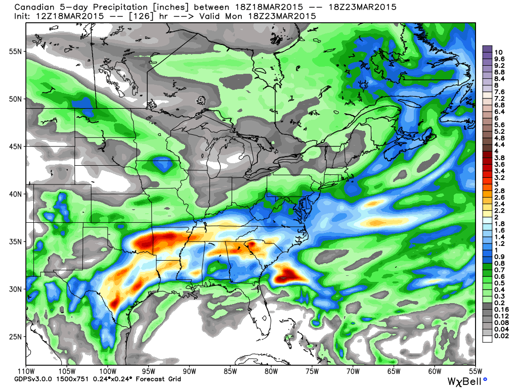
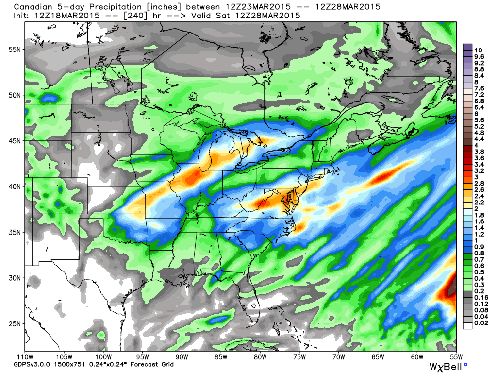
Heaviest rains target the lower Ohio Valley and Tennessee Valley week 1 before shifting north week 2.  The heavy precipitation axis points a finger from OK and AR through MO and IL, northern IN, and MI week 2.

Some of this heavier rain is just what the Doctor ordered for areas beginning to reflect abnormally dry conditions and/ or drought.

20150310_south_none

20150310_midwest_none
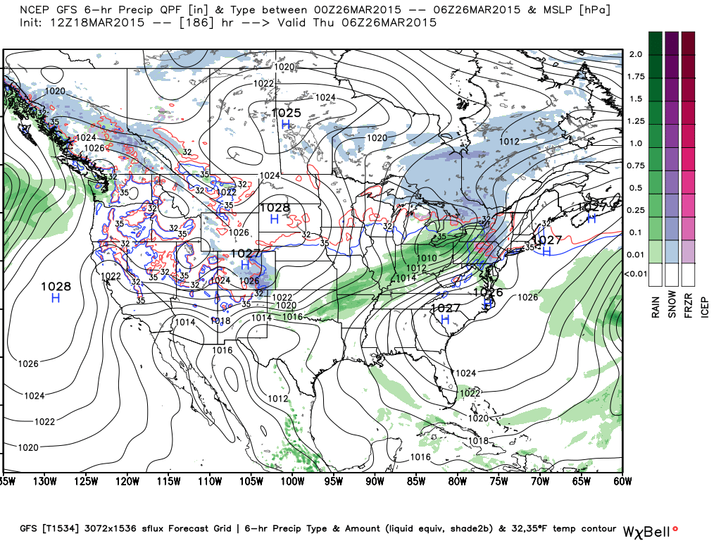
We track a weak, but cold system early next week that could deliver a touch of light wet snow Monday.  The GFS led the way on this, but the European and Canadian have jumped on board with today’s runs.

Monday


Another (stronger) storm system is in the offing later next week.  This should be the one that delivers heavy rains from the mid south on northeast.

Thursday


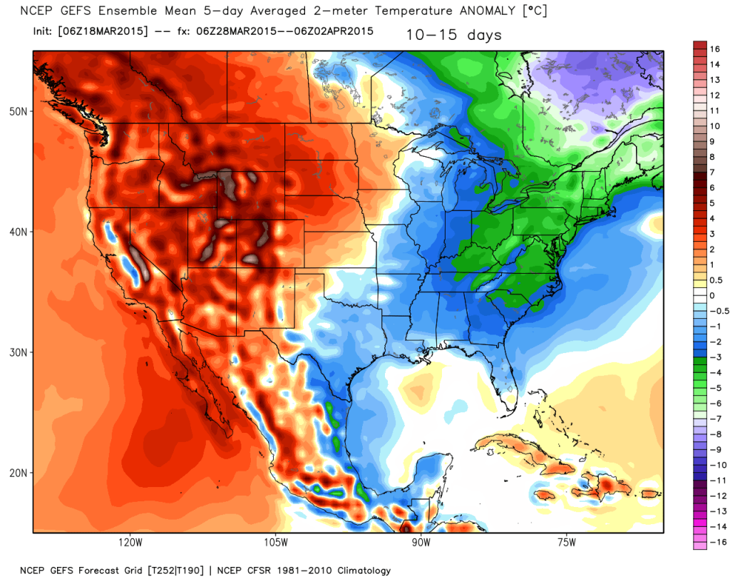
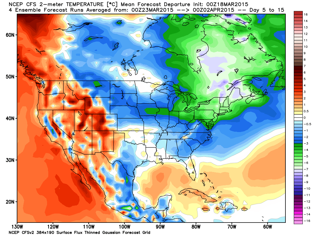
Looking ahead towards late month into early April, temperatures will reflect the normal “roller coaster” regime for this time of year; however biased colder than normal.  Note the excellent model consensus on the colder than average regime.

2015031800_054@007_E1_north@america_I_NAEFS@TEMPERATURE_anomaly@probability@combined@week2_198


gefs_t2anom_by5_conus_61


cfs_anom_t2m_conus_2015031800_x61

Permanent link to this article: https://indywx.com/31815-ag-weather-report/

Clouds Slowly On The Increase…

Screen Shot 2015-03-18 at 9.34.52 AMClouds Increase; Light Rain Thursday…The day is off to a much colder start, but also a sunny one.  Mid and high level cloudiness will slowly be on the increase as we progress through the day and these clouds will give way to some light rain Thursday.  The culprit?  An area of low pressure passing to our south.  Enough cold air will be in place to create a transition to some wet snow across northeastern portions of the state late Thursday night into early Friday morning.

The area will enjoy a southwesterly air flow and associated milder air mass for the first part of the weekend, but a cold front will pass Saturday night and usher in a colder Sunday.

A fast moving storm system will scoot through central Indiana Monday and team up with the colder air in place to lead to a mixture of cold rain and wet snow.  Precipitation amounts will be light with this system.  We’re back to a dry, chilly theme Tuesday.

Upcoming 7-Day Precipitation Forecast:

  • 7-Day Snowfall Forecast: Trace
  • 7-Day Rainfall Forecast: 0.10″-0.25″

Permanent link to this article: https://indywx.com/clouds-slowly-on-the-increase/

Touching Base On A Saturday Afternoon…

You must be logged in to view this content. Click Here to become a member of IndyWX.com for full access.  Already a member of IndyWx.com All-Access?  Log-in here.

Permanent link to this article: https://indywx.com/touching-base-on-a-saturday-afternoon/

Now We’re Talking…

Screen Shot 2015-03-07 at 10.30.32 AMSpring Fever Anyone?!  A weak weather system is racing through the region this morning.  Clouds and gusty southwest winds are accompanying this, but the air mass is too dry to sustain any sort of precipitation (with the exception of a snow flurry across northern portions of the state).  Sunshine should increase as we progress from morning into the afternoon hours.  Although we’ll remain colder than average this weekend, highs in the lower 40s will feel downright balmy when compared to the bitterly cold times we’ve gone through over the past several weeks.

Early next week will feature a wet weather maker move northeast out of the Deep South, but this should remain east of our region.  We note the European model tries to deliver some light rain Tuesday, but for now we’ll keep our forecast rain-free and dry.

A real surge of “spring fever” will push in here by the middle of the week with highs in the middle 50s Wednesday and upper 50s Thursday (some areas will touch 60 Thursday).  White Leg Warnings will have to be issued, no doubt ;-).

Unfortunately, weather conditions will take a dramatic turn downhill late week into the weekend as a big storm system lifts north out of the Gulf of Mexico.  Colder and raw times are ahead, including a gusty wind-driven rain.  Moderate to heavy rainfall totals appear to be a good bet from 6-7 days out.

Upcoming 7-Day Precipitation Forecast:

  • 7-Day Rainfall Forecast: 0.50″ – 1.00″
  • 7-Day Snowfall Forecast: 0.00″

Permanent link to this article: https://indywx.com/now-were-talking/