Category: snow

VIDEO: Pick Of The Week; Much More Active Time Of Things To Close January…

Updated: 01.13.21 @ 7:14a

You must be logged in to view this content. Click Here to become a member of IndyWX.com for full access.  Already a member of IndyWx.com All-Access?  Log-in here.

Permanent link to this article: https://indywx.com/video-pick-of-the-week-much-more-active-time-of-things-to-close-january/

1st Wintry “Jab” Blows Into Town This Weekend In What Should Be A Stormy Finish To January…

Updated 01.12.21 @ 8:08a

Finally we can breathe a sigh of relief as the seemingly unending low cloud deck erodes and gives way to increasing sunshine today. Along with a return of the sun will be a moderating trend in the temperature department. Expect highs in the low 40s today and mid 40s Wednesday and Thursday as a southwesterly flow develops ahead of Friday’s cold front.

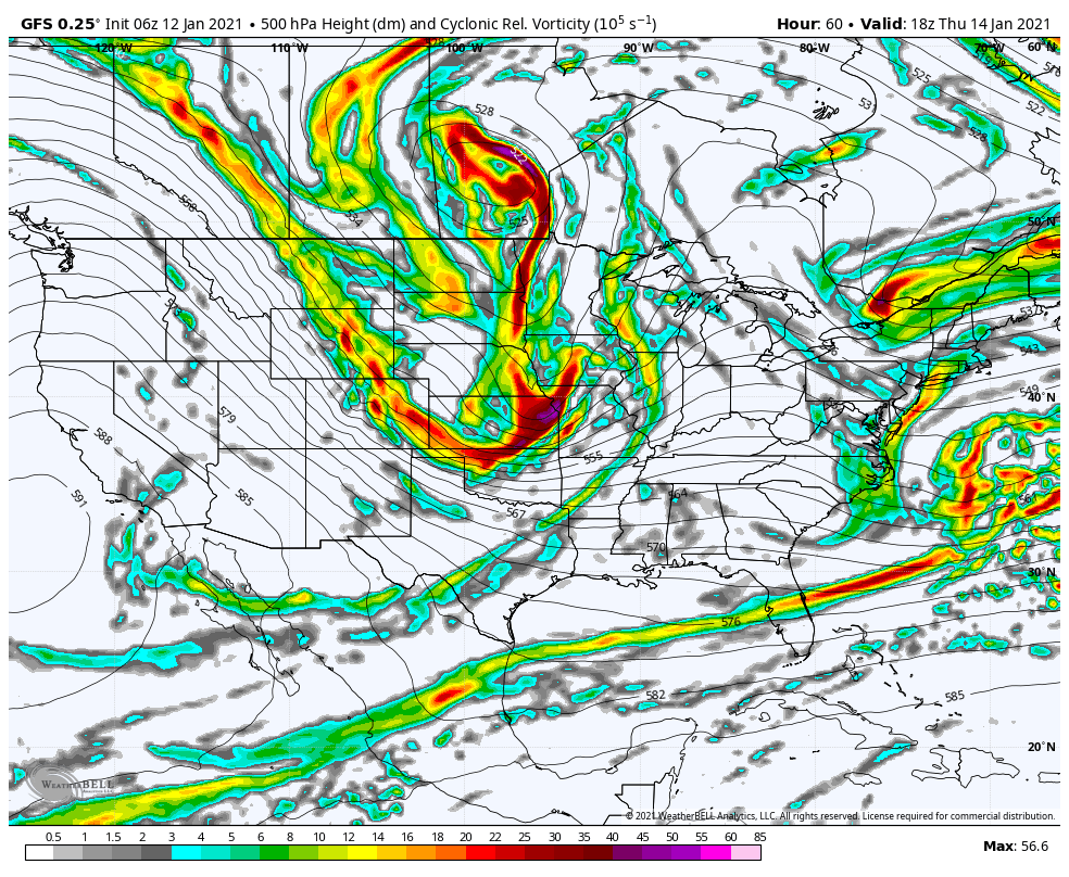
The cold front, itself, will swing through central Indiana late Thursday night and early Friday morning. While we still think this will be a mostly dry FROPA (frontal passage), models are becoming more robust with a “bowling ball” of an upper level low pressure system over the weekend.

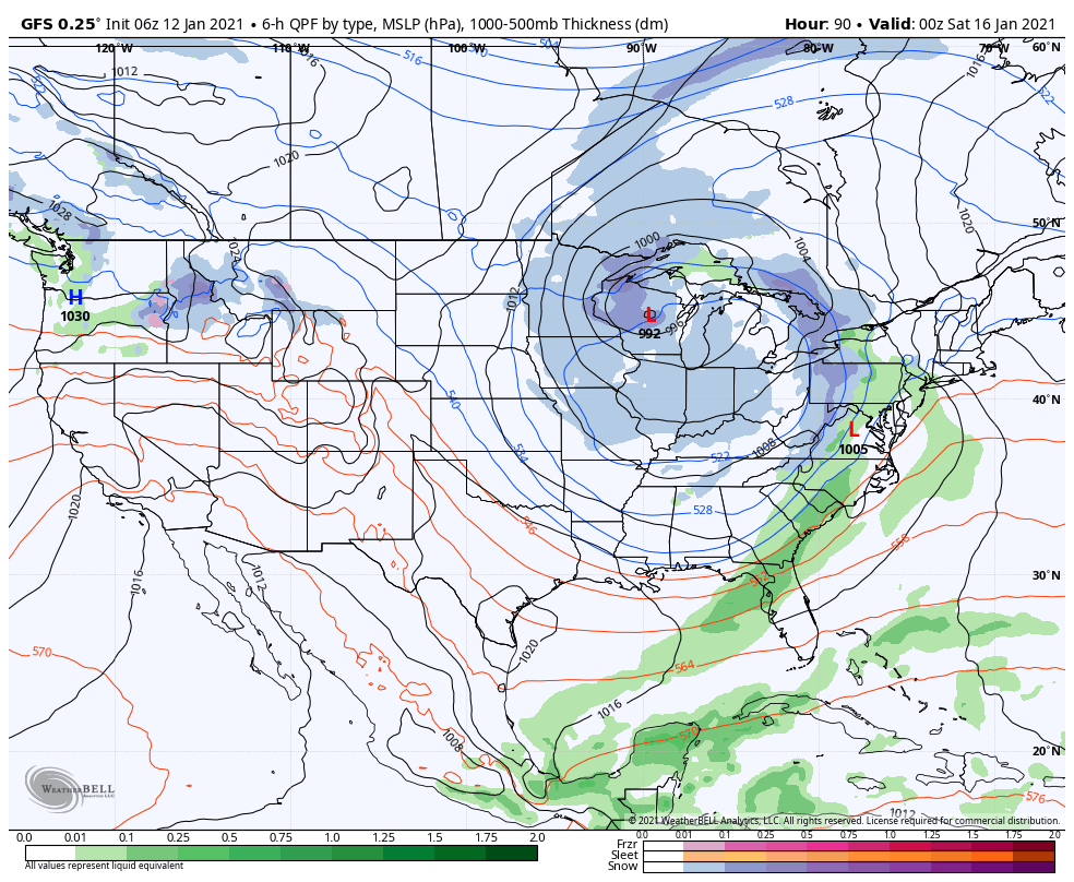
Note how the upper low becomes almost cut off from the primary steering flow for a time Saturday across the Great Lakes region. Additional “spokes of energy” (upper level disturbances) will pivot south of the primary cut off low across the Ohio Valley Friday night through Sunday afternoon. This will help lead to enhanced periods of snow and snow showers throughout the weekend.

We’re still not looking at heavy snowfall, but the rather persistent nature of light snow this weekend will accumulate to an inch or two for some communities along with a much colder air mass. After Friday evening, temperatures won’t make it above freezing again likely until Tuesday afternoon.

When we look at the bigger picture, this will likely go down as the first “jab” of more exciting weather to wrap up the month of January.

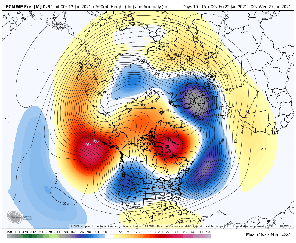
While still not overly cold (doesn’t have to be this time of year for wintry issues to arise), the pattern does look very, very active through the 2nd half of January and to open at least the 1st week of February. While the Greenland Block continues to mature, note the change in the Pacific. We may finally be able to get a negative EPO to develop to align with the negative AO and NAO.

If this does, indeed, transpire we should see a rather expansive snowpack get laid down across the country during the last week to 10 days of January. It would then be this time into early February to look for the possibility of more significant arctic air to spread out and cover more of the Lower 48 (after initially likely being bottled up in western Canada and the northern Rockies).

At the very least, times are becoming more interesting. It’ll be a fun ride through the rest of the month and to open February.

Permanent link to this article: https://indywx.com/1st-wintry-jab-blows-into-town-this-weekend-in-what-should-be-a-stormy-finish-to-january/

VIDEO: Milder By Midweek; Pattern Evolves Towards A More “Nina-like” Regime Over The Next Couple Weeks…

Updated: 01.11.21 @ 7:42a

You must be logged in to view this content. Click Here to become a member of IndyWX.com for full access.  Already a member of IndyWx.com All-Access?  Log-in here.

Permanent link to this article: https://indywx.com/video-milder-by-midweek-pattern-evolves-towards-a-more-nina-like-regime-over-the-next-couple-weeks/

01.10.21 Weather Bulletin: Moderating Ahead Of A Late Week Cold Front…

Updated: 01.10.21 @ 11:28a

Moderating Trends Gets Underway Monday…The 2nd half of the weekend will feature more of what we’ve grown so used to as of late: overcast conditions. With the thick cloud deck in place, afternoon highs won’t budge much. As we flip the page to the new work week, a milder westerly and southwesterly air flow will turn gusty at times (especially by midweek), but this will also help boost temperatures to levels around 10° above normal. We should also see a little more of that vitamin D through midweek.

We’re still targeting a cold front to blow through our neck of the woods Friday. This, coupled with just enough upper level energy, will likely be enough to ignite a brief period of scattered snow shower action Friday PM. Colder air will settle into the area next weekend…

Permanent link to this article: https://indywx.com/01-10-21-weather-bulletin-moderating-ahead-of-a-late-week-cold-front/

VIDEO: Weather Pattern Turns Much More Interesting By Mid-Month…

Updated 01.09.21 @ 4:43p

You must be logged in to view this content. Click Here to become a member of IndyWX.com for full access.  Already a member of IndyWx.com All-Access?  Log-in here.

Permanent link to this article: https://indywx.com/video-weather-pattern-turns-much-more-interesting-by-mid-month/