Category: snow

Busy Pattern To Close Out The Year And Open 2022…

Updated 12.27.21 @ 4:58p

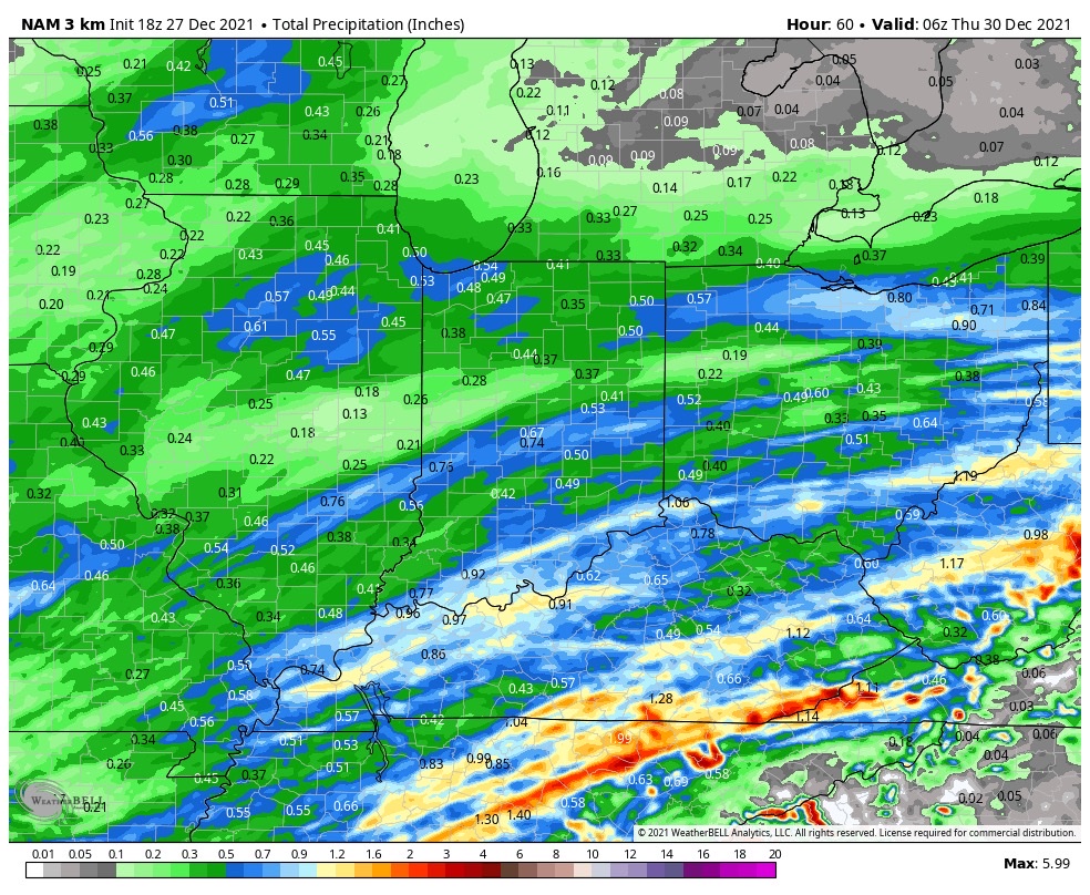
A busy weather pattern will be with us as we wrap up the year and head into 2022. The first in a seemingly unending series of systems will blow into town Tuesday and feature a period of heavy rain across central Indiana by afternoon, along with a shot of wintry weather for our neighbors across northern Indiana.


Forecast radar valid 2p Tuesday

Additional (lighter) rain will arrive Wednesday evening. Rain will approach 3/4 of an inch across the greater Indianapolis area and snowfall should span within the 1” to 3” range for most across far northern Indiana Tuesday PM.


Additional storm systems will roll through here Wednesday night and Thursday and again Friday night and Saturday. The 3rd storm system appears to be the most significant within this batch and should lead to a messy New Year’s Day, including opportunity for additional heavy rain.

For those with travel plans north around New Years, expect the opportunity to encounter more impactful wintry conditions across areas just to our northwest with that system. Early indications suggest this could be a heavy snow maker for areas from the central Plains into the lower Lakes.

On that note, let’s keep close eyes on trailing upper level energy that may lead to a “surprise” second area of snow south with the New Year’s system. This is met with much lower confidence (always is with trailing upper lows in the medium term), but the overall pattern does support the potential of a secondary area of accumulating snow and we’ll keep a close eye on that moving forward. Ohio Valley, TN Valley, or even further east? Anyone’s guess at this point and we’ll continue to closely monitor…

Permanent link to this article: https://indywx.com/busy-pattern-to-close-out-the-year-and-open-2022/

VIDEO: Light Snow Develops This Afternoon Across Southern IN; Record Warmth Next Week?

Updated 12.07.21 @ 7:30a

You must be logged in to view this content. Click Here to become a member of IndyWX.com for full access.  Already a member of IndyWx.com All-Access?  Log-in here.

Permanent link to this article: https://indywx.com/video-light-snow-develops-this-afternoon-across-southern-in-record-warmth-next-week/

VIDEO: Colder To Open The Work Week; Discussing The Reasons Why It’s Important To Stay On Guard For Potential Big Changes To The Pattern Late Month…

Updated 12.06.21 @ 7:30a

You must be logged in to view this content. Click Here to become a member of IndyWX.com for full access.  Already a member of IndyWx.com All-Access?  Log-in here.

Permanent link to this article: https://indywx.com/video-colder-to-open-the-work-week-discussing-the-reasons-why-its-important-to-stay-on-guard-for-potential-big-changes-to-the-pattern-late-month/

VIDEO: Showers Build In Later Today; Light Snow Event Tuesday…

Updated 12.05.21 @ 11a

You must be logged in to view this content. Click Here to become a member of IndyWX.com for full access.  Already a member of IndyWx.com All-Access?  Log-in here.

Permanent link to this article: https://indywx.com/video-showers-build-in-later-today-light-snow-event-tuesday/

Saturday Morning Long Range Musings And A Note On The Shorter Term Pattern…

Updated 12.04.21 @ 7:50a

With a current combo of the PNA, EPO, and Phase 6 of the MJO, there will be absolutely no denying a period of significant warmth (for the time of year) over the coming couple of weeks- especially during the Week 2 timeframe.

What we now look ahead towards is if, indeed, we can get the MJO into Phase 7 and, if so, with staying power. If so, do we continue to rumble into Phase 8 or try and sneak back into Phase 6? Those are questions that will be answered in the coming weeks and be a big reason in either pulling in a rather significant pattern shift towards cold, or keep things on the milder side. The hunch here is that we will get into 7 and 8, but the duration is in question. In any event, these are the temperature composites in Phase 7 (December) and Phase 8 (January).

In any event, one can see the potential on the table…

In the shorter term, the pattern in the week to 10 days ahead will take a turn towards the more active. Sunday will feature the first of (3) storm systems we’re tracking in the upcoming week, including the opportunity of wintry weather (more on that later this wknd) Tuesday into early Wednesday.

Permanent link to this article: https://indywx.com/saturday-morning-long-range-musings-and-a-note-on-the-shorter-term-pattern/