Category: Short term update

Unsettled Week Ahead…

After an unseasonably cool and dry week to open the month, much more active times await as we head into the middle of August.

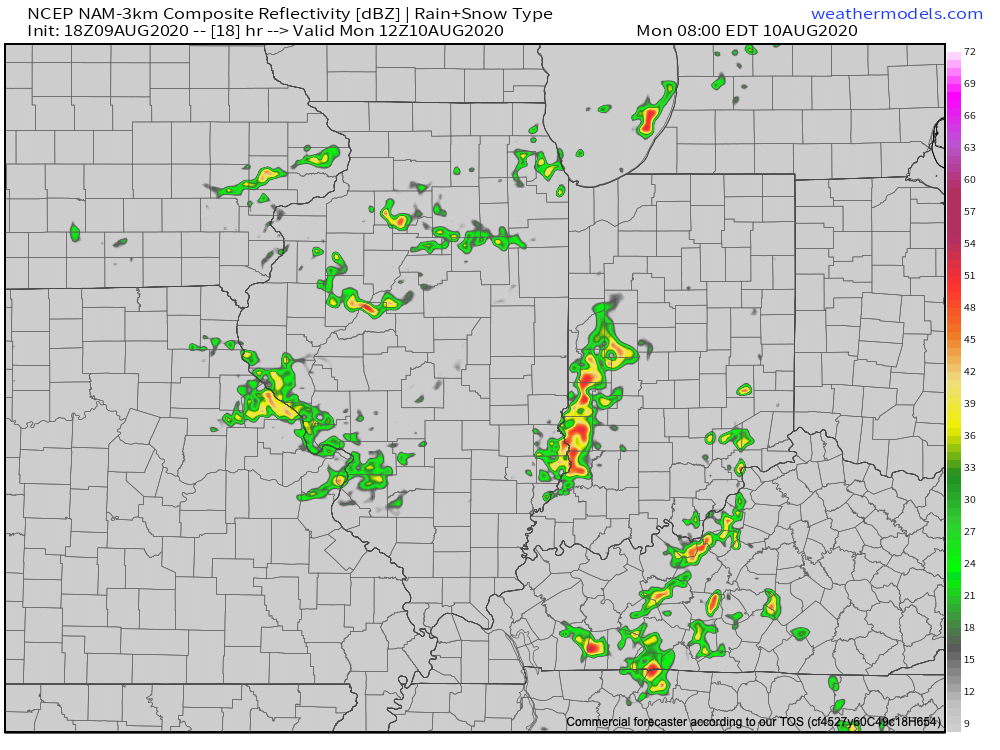
Upper air disturbances will ride southeast into the region to open the work week on the nose of a much more humid airmass trying to invade the area. These ripples of energy will be enough to lead to more organized thunderstorms, including locally heavy rain at times. Unlike what’s typical this time of year, this week will feature times of storms that rumble in during the nighttime and morning hours.

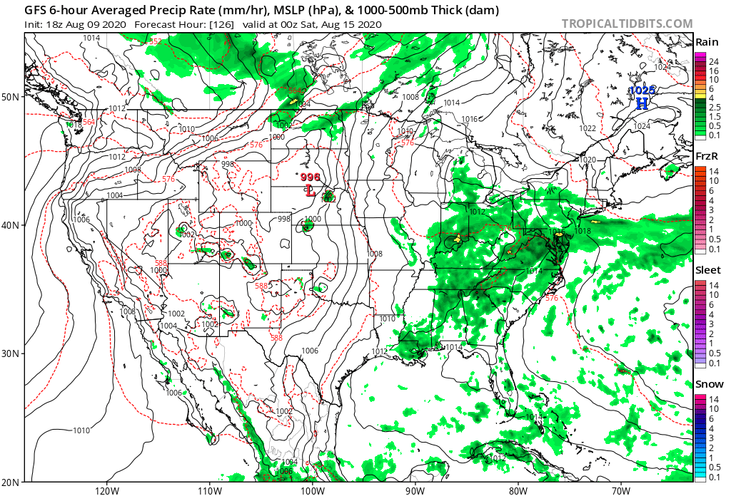
A frontal boundary will settle south into the region during the middle and latter parts of the work week before stalling out. This will serve as a focal point for additional thunderstorm chances for the 2nd half of the week, continuing into the weekend.

While it’ll be a warmer week, it’s more the humidity that will really make a difference. Daytime highs will remain close to average this week, overall, but overnight lows will be muggy- only falling to around 70° most nights.

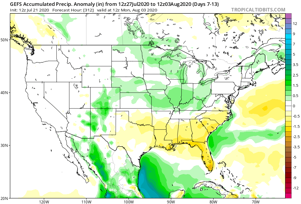
We have no changes to our weekly rainfall forecast: 1″ to 2″ for most with localized heavier totals where stronger storms track.

  • I’ll be on the road tomorrow and will have our client video posted Monday evening.

Permanent link to this article: https://indywx.com/unsettled-week-ahead/

Another Round Of Storms Inbound Tonight (Some Strong); Tropics Heat Up; Active Pattern To Close July-Open August…

I. A round of strong (and locally severe) storms blew through north-central parts of the state earlier this afternoon and as we write this, yet another batch of storms is erupting across IL. These storms should hold together into central IN late evening (targeting a 8p-11p arrival west to east) and a few could become severe. Ingredients in place favor strong, damaging wind gusts with the stronger cells, but there’s also the opportunity for a quick spin-up tornado. Torrential downpours can be expected with any and all storms. It’ll be wise to keep tabs on the local radar this evening.

II. As can be expected the deeper into summer we go, the tropics become more active. That’s certainly been the case over the past couple days and all indications continue to point towards a particularly “robust” season as late summer gives way to fall. Interests to the Gulf Coast beaches and Carolina coast should pay close attention to the tropical outlooks in the coming weeks and months. Unfortunately, conditions seem ripe for the opportunity of a few major hurricanes this season, especially when you combine the SST profile with the tendency for the MJO to spend time in Phases 2-3.

In the shorter term, the National Hurricane Center (NHC) is keeping close tabs on the Gulf as well as newly formed TD 7.

III. Overall upper pattern strongly suggests we can expect a very active close to July and open to August. Between next week and the first few days of August, we’re tracking 3 cold fronts that will help to beat back the heat and serve up above normal rainfall through the period (not to mention threat of additional strong to severe storms).

Permanent link to this article: https://indywx.com/another-round-of-storms-inbound-tonight-some-strong-tropics-heat-up-active-pattern-to-close-july-open-august/

Evening Update On Severe Weather Currently To Our West…

You must be logged in to view this content. Click Here to become a member of IndyWX.com for full access.  Already a member of IndyWx.com All-Access?  Log-in here.

Permanent link to this article: https://indywx.com/evening-update-on-severe-weather-currently-to-our-west/

Off To The Races; Warmth Met With Periodic Storms…

A band of light showers is falling across southern Indiana this morning, but these are expected to diminish before pushing into central Indiana. Most of the remainder of our Wednesday should be rain-free.

The quiet times will give way to a couple of rounds of storms during the overnight and into Friday. Most notably for central Indiana, we think storm chances will increase significantly after midnight and through the predawn hours Thursday. Locally heavy rain and vivid lightning is expected with the stronger storms.

These storms are in association with a warm front lifting north through the state. Speaking of warm, we’ll certainly notice a difference in air masses between today (still relatively cool and dry) and tomorrow (much warmer and more humid). In fact, highs Thursday will flirt with 80° across most of central Indiana.


Once we get rid of the early morning storms, most of the remainder of our Thursday will be dry and feature a return of the sun.

Another round of storms is expected Thursday night into Friday, but most of these will remain well north of our area. A few of these could become severe across northwestern Indiana during this period.

Rain and storm chances will increase once again during the day Friday across central Indiana. A few strong storms will be possible.

As we look ahead to the weekend, it appears we’ll be able to enjoy a mostly dry day Saturday (widely scattered storm possible) before more widespread storms return Sunday. Warm and humid conditions will prevail. A cold front will move through the area early next week which will allow for briefly cooler, drier air to move in during the 1st half of next week. Before that takes place, rainfall amounts between tonight and Sunday are expected to range from 1.5” – 2” with locally heavier totals across central Indiana. Heavier rainfall amounts can be expected across northern Indiana (widespread 3” to 4” amounts during the same period).

Permanent link to this article: https://indywx.com/off-to-the-races-warmth-met-with-periodic-storms/

Evening Video Update: Timing Out Weekend Rain And Looking Ahead To A Chilly Open To May…

You must be logged in to view this content. Click Here to become a member of IndyWX.com for full access.  Already a member of IndyWx.com All-Access?  Log-in here.

Permanent link to this article: https://indywx.com/evening-video-update-timing-out-weekend-rain-and-looking-ahead-to-a-chilly-open-to-may/