VIDEO: Stormy 24 hours Ahead; Amplified Pattern This Week…
You must be logged in to view this content. Click Here to become a member of IndyWX.com for full access. Already a member of IndyWx.com All-Access? Log-in here.
You must be logged in to view this content. Click Here to become a member of IndyWX.com for full access. Already a member of IndyWx.com All-Access? Log-in here.
I. Tracking multiple cold fronts this week.
II. Pattern transitions cooler than normal as we move through the 1st (10) days of September.

Forecast Period: 08.29.20 through 09.05.20
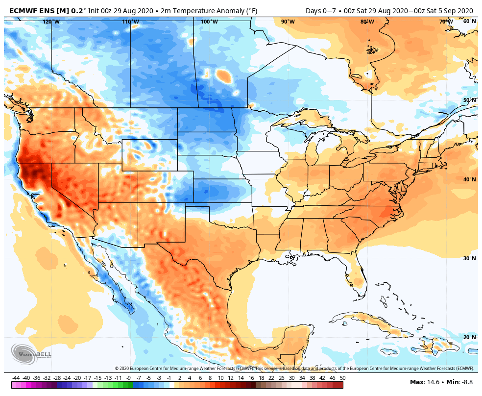
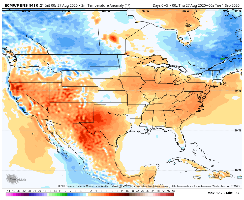
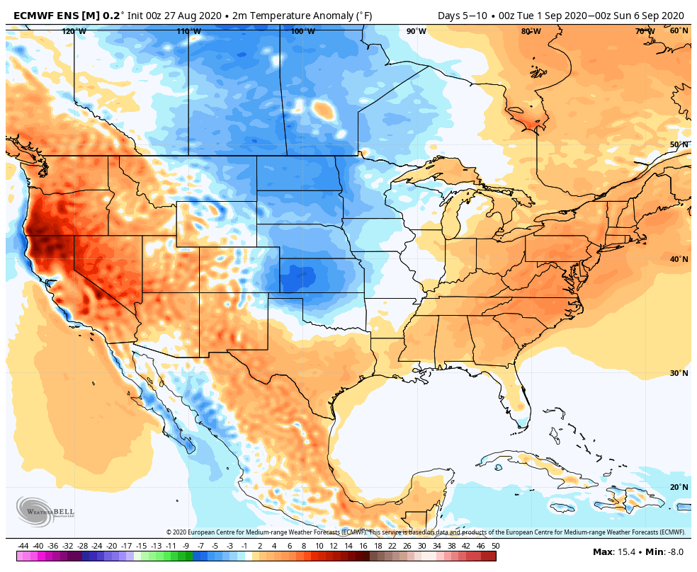
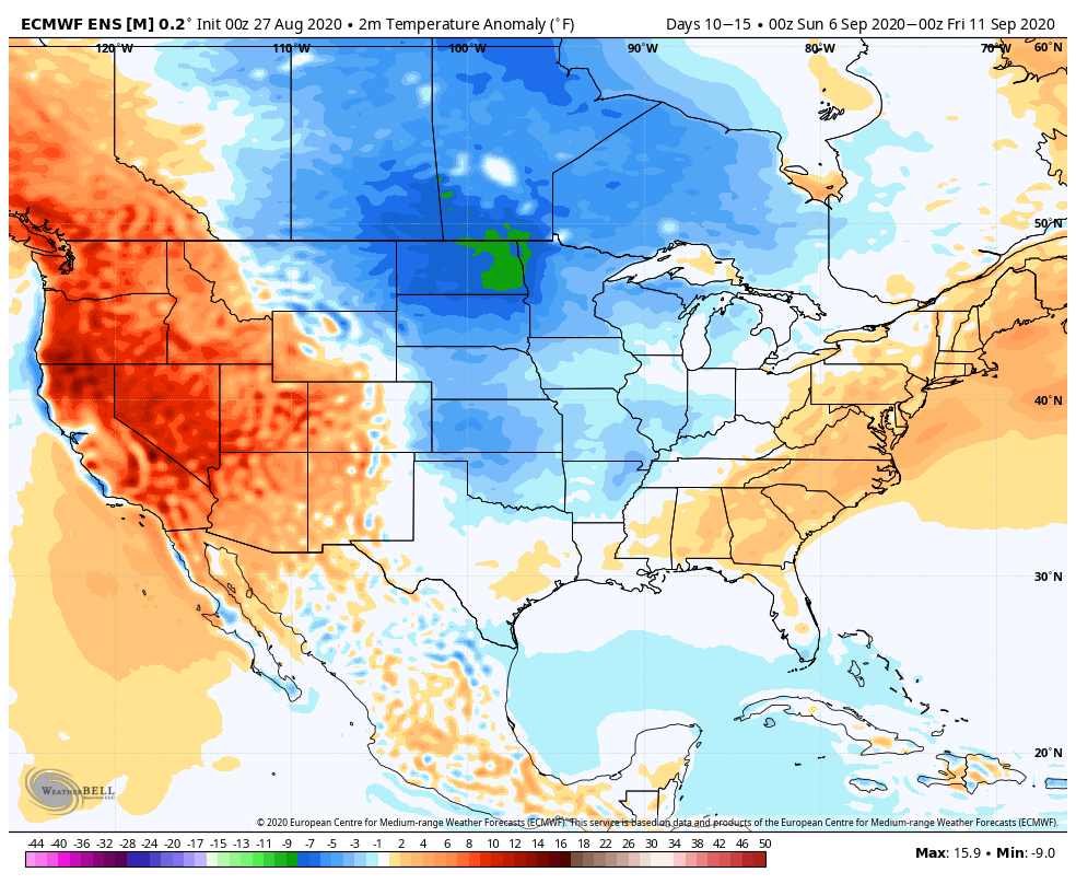
As we flip the page from meteorological summer to fall, a more active pattern can be expected, locally. Of course we already had one cold front sweep through the region this morning and we’re tracking 3 additional fronts between now and Labor Day. The 2nd front will move through midweek with scattered showers and storms Tuesday afternoon and Wednesday. The 3rd front will arrive Friday with yet another scheduled for a passage Labor Day night. Each front will provide an enhanced chance of showers and embedded thunder, but washouts aren’t anticipated any of the days through the upcoming week. Temperatures will run near seasonal norms before trending much cooler behind the Labor Day front (late September or early October like temperatures).
You must be logged in to view this content. Click Here to become a member of IndyWX.com for full access. Already a member of IndyWx.com All-Access? Log-in here.
Before we dive into our latest long range discussion, Laura continues to track north this morning through western Louisiana, and remains a category 2 as of the latest update (5a eastern time). Our thoughts and prayers are with all of those affected by Laura as they wake up this morning and begin to see the horror left behind from this beast of a storm.
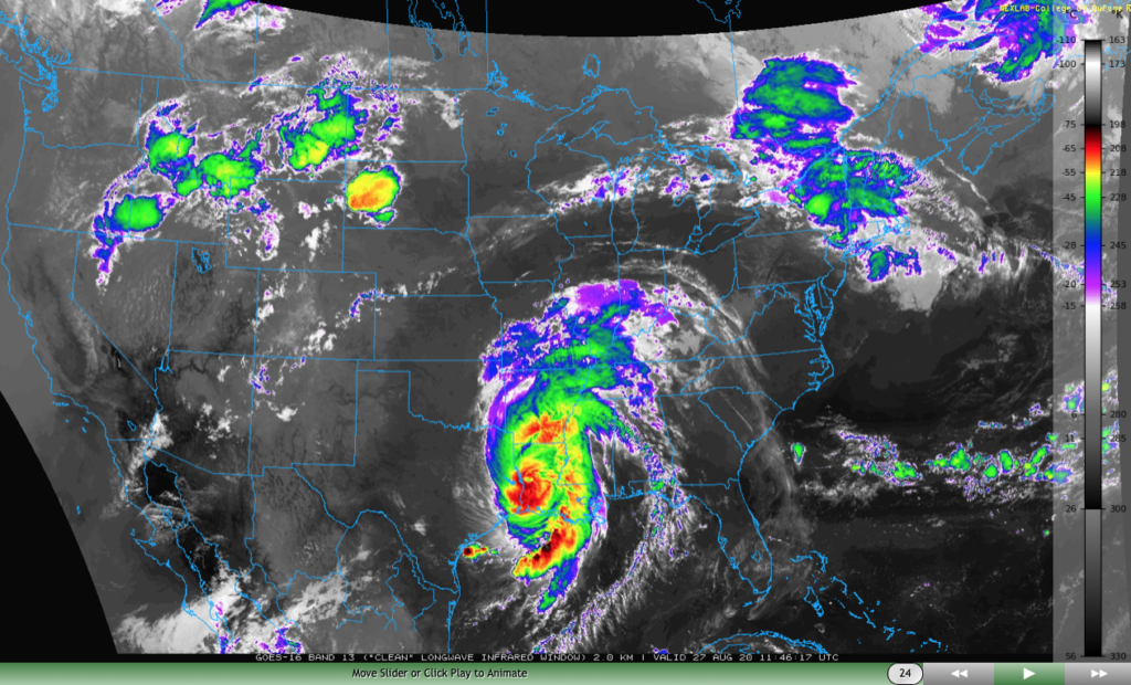
Laura will take a hard “right” turn Friday and deliver gusty winds and heavy rain to the TN Valley and into the mid-Atlantic through the weekend.

We won’t deal with any impacts from Laura’s remnants up this far north, but we will increase coverage of shower and thunderstorm activity now through Saturday evening. This is thanks to a warm, sultry airmass in place along with an approaching cold front. As that boundary drives through the region Saturday evening, a much drier airmass will arrive for the 2nd half of the weekend.

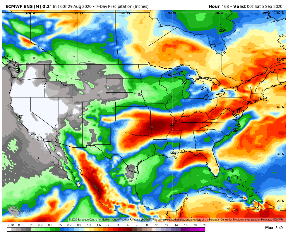
Rainfall amounts between this afternoon through Saturday afternoon should top out between 0.50″ and 1″ for most, but there will be localized 1″ to 2″ totals in the heavier storms.
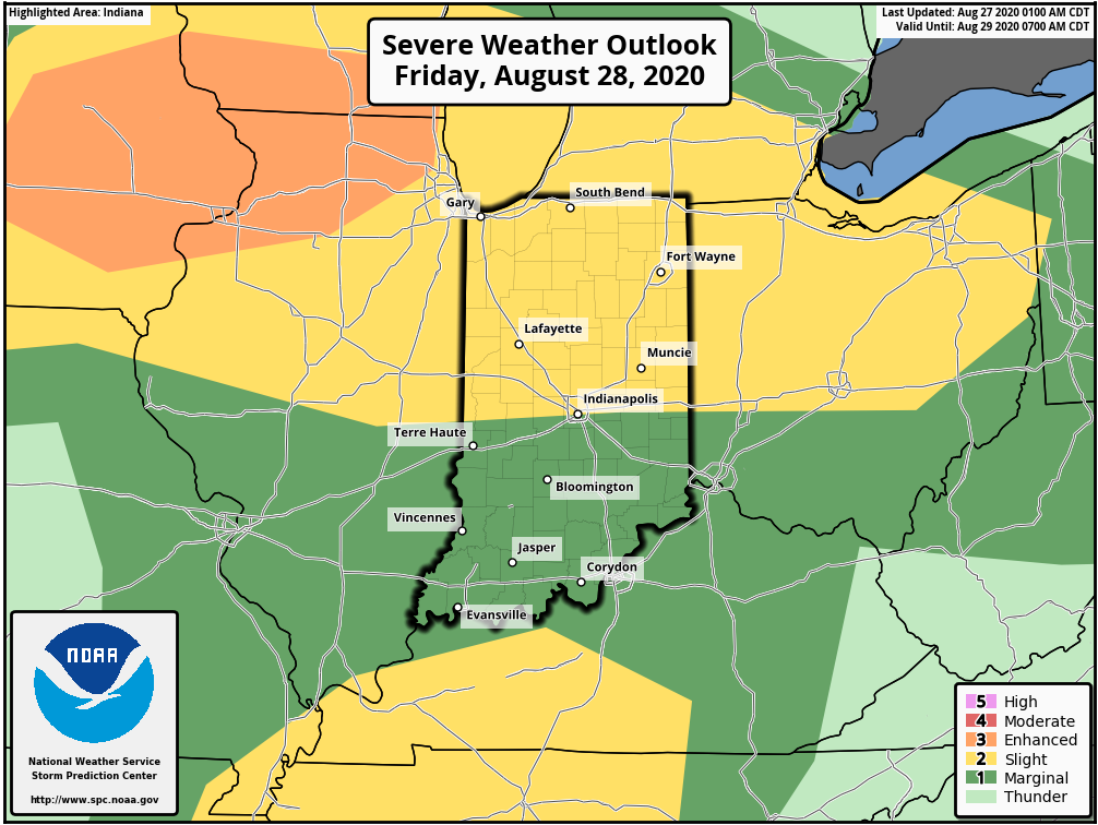
Friday will also pose a severe weather threat across the state, including the potential of damaging straight line winds as a couple “bowing” segments that move from the upper Midwest into the central Ohio Valley.
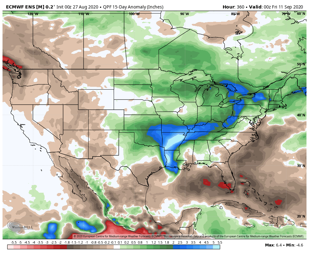
As we look ahead, we’re tracking 3 significant cold fronts between now and September 10th:
I. Aug. 29th
II. Sept. 3rd
III. Sept. 10th
Each of these cold fronts will be capable of producing strong storms and locally heavy rain, and behind each boundary, the air will grow cooler and cooler. While “transitional” warmth (relative to normal) is likely ahead of the boundaries, the first 1/3 of September should run cooler than normal across our region. Things also looks MUCH wetter than normal through the upcoming couple of weeks- a byproduct of the busy nature of the pattern.
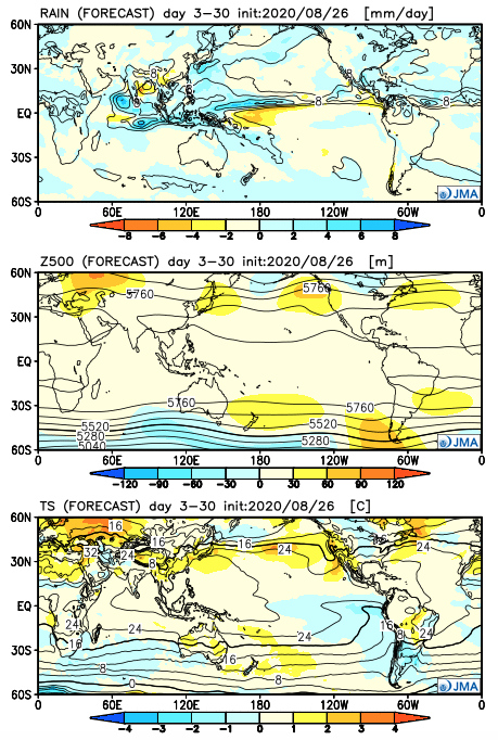
Note how the latest JMA Weeklies are also similar handling the pattern (we’ll take the week-by-week snap shots into our video a bit later) over the upcoming 3-4 weeks:
One more item of note, the tropics aren’t done, unfortunately. There should be another hurricane threat in the medium to longer range period (early September) and early thoughts here include that threat centering more on the East Coast vs. the Gulf.
I. Tropics claim headlines this week.
II. Summer-like temperatures and humidity returns.


Forecast Period: 08.22.20 through 08.29.20
A historic tropical event is likely to impact the Gulf of Mexico this week as not one, but two named tropical systems (likely both hurricanes) track north, northwest and target the central and western Gulf Coast. While additional fluctuations in the ultimate track and subsequent point of landfall can be expected over the next couple of days, confidence is increasing on the likelihood of 2 hurricanes making landfall within 36-48 hours of each other somewhere from the MS coast to the LA and TX coast. This won’t only be a coastal issue, but quickly grow into a big inland flood situation for the lower MS Valley and into the TN Valley as we get into the middle and latter parts of the week.
Back home, a much more typical summer-like regime can be expected this week, including a return of heat and humidity. While splash and dash coverage of storms is expected Sunday evening into Monday, most of the upcoming week looks rain-free, at least until late week. That’s when a stronger cold front will take aim on the region and increase shower and thunderstorm chances Thursday into Friday. To add further complexity into the equation, we’ll also have to monitor the remnant tropical moisture moving north, as it’s still possible some of this moisture gets entangled with the cold front. Whether or not this is the case or not is yet to be seen and will be the cause of great whaling and gnashing of teeth this week. Regardless, unlike with some tropical remnants, the upper pattern supports a fairly quick movement of the remnants once to midweek, so that would greatly limit flooding potential up this far north.
The early call on next weekend is for a drier regime to begin building in.