You must be logged in to view this content. Click Here to become a member of IndyWX.com for full access. Already a member of IndyWx.com All-Access? Log-in here.
You must be logged in to view this content. Click Here to become a member of IndyWX.com for full access. Already a member of IndyWx.com All-Access? Log-in here.
You must be logged in to view this content. Click Here to become a member of IndyWX.com for full access. Already a member of IndyWx.com All-Access? Log-in here.
When we look at the “big driver” teleconnections over the next 10-14 days, it’s easy to understand why the active weather pattern is expected to continue. The NAO is expected to run predominantly negative over the next couple weeks (which favors eastern chill), but the EPO is expected to fluctuate between positive and negative phases and the MJO is showing signs of pushing into Phases 7 and 8 (favors eastern warmth this time of year).
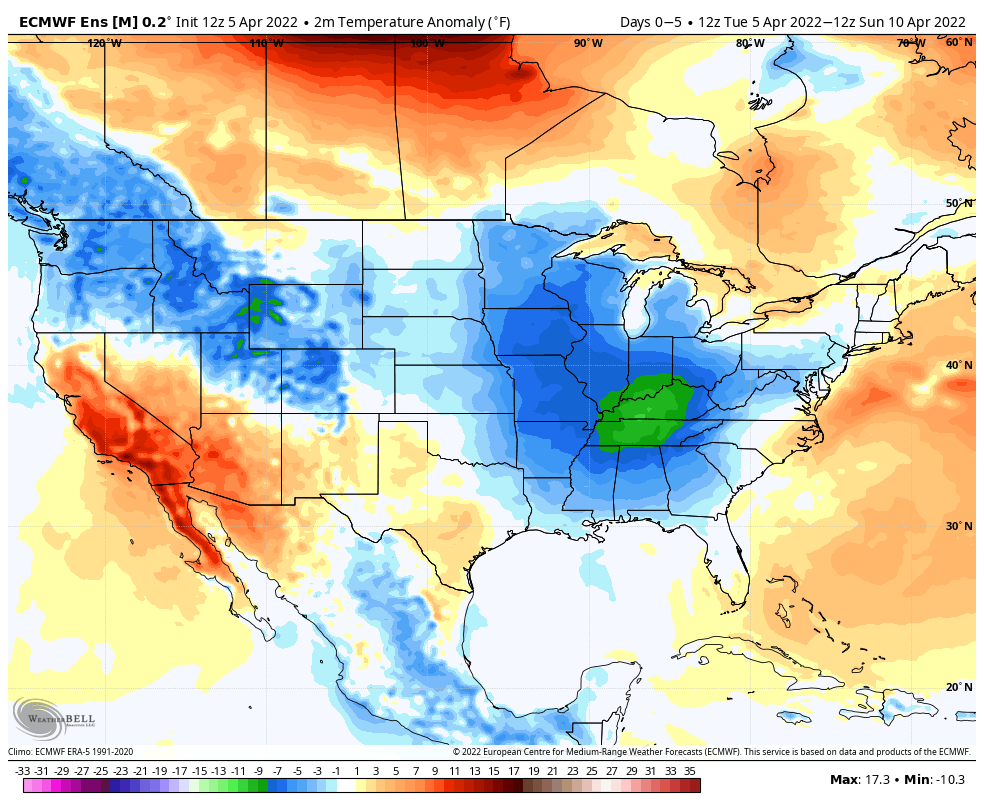
The temperature regime over the next couple of weeks will fluctuate between periods of above normal warmth and well below normal chill. Despite a significant bump in the temperature regime next week, the unseasonably chilly conditions will return with authority late next week, including the threat of frost.
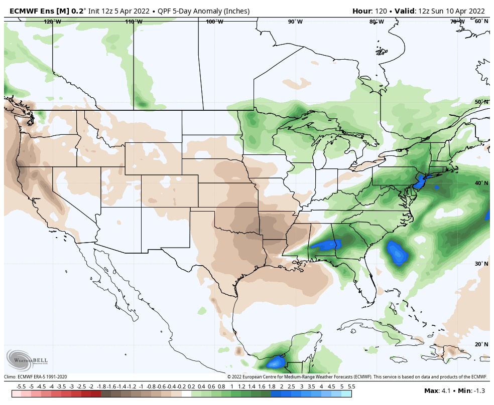
As you’d imagine in this kind of setup, the precipitation pattern will also go through a period of fluctuation. The heaviest precipitation anomalies will center in on the middle of next week through the latter part of the week and may also be met with the potential of severe weather during this time frame (targeting next Thursday for this threat, though this is subject to change as we draw closer and may have to be fine tuned).
Much more in tomorrow’s long range video discussion which will be posted Thursday night due to morning travel.
We’ve already handled the jab of unseasonable chill and even opportunity for wet snow showers late week so want to focus more on what lies ahead. The idea here has been that a mid month warm up would pave the way to more sustained spring like temperatures for the 2nd half of April. While the mid month warmup is still certainly on track, the longevity and duration of such is now met with a much, much lower confidence.
The good news? A significant warmup is still dialed up next week. (This will be extra sweet coming on the heels of what will be a rough go of things with out of season chill and snow showers later this week). Highs in the 70s and even low 80s are a good bet next week.
A potent frontal system looms late next week that we’ll have to watch for the threat of severe weather. More on that ahead in our shorter term products as we get closer. The passage of this front will also likely usher in another airmass that’s set to run below, to well below normal. Frost potential is alive and kicking week after next (remember we also have to deal with frost/ freeze conditions this upcoming weekend) with this kind of pattern. The NAO takes a negative hit which also supports the temperature reversal from what will be such a warm stretch next week…
Remember, we’re only the messenger…
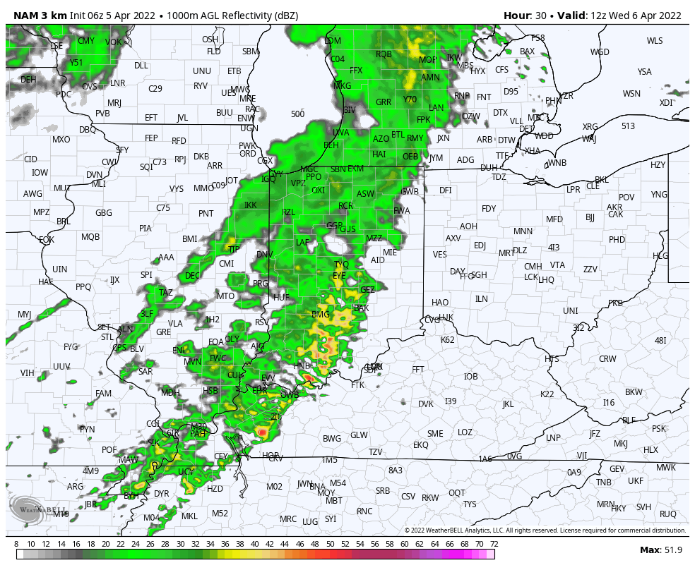
In the shorter term, today isn’t looking nearly as wet as once thought. There will be a few showers around, but the steadier, more persistent rain will fall to the southeast of central Indiana.
More widespread rain and even a couple embedded storms are slated to impact our neck of the woods Wednesday morning.