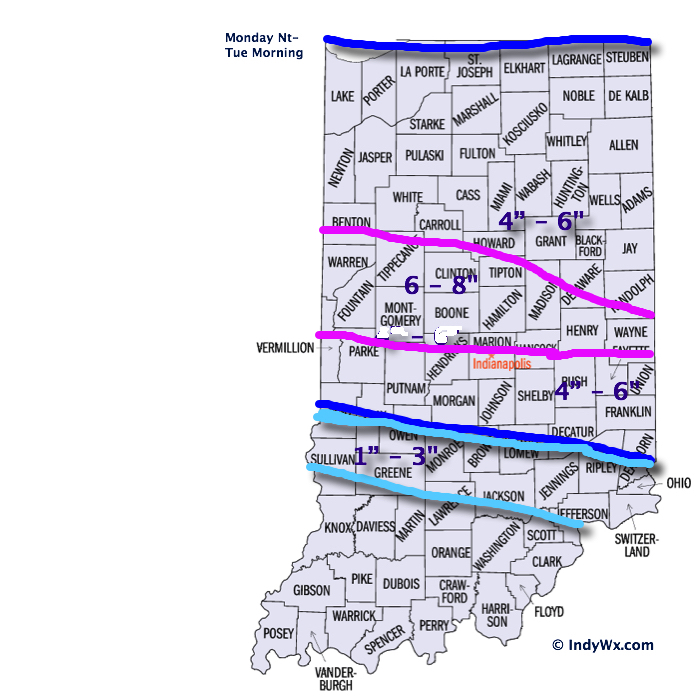
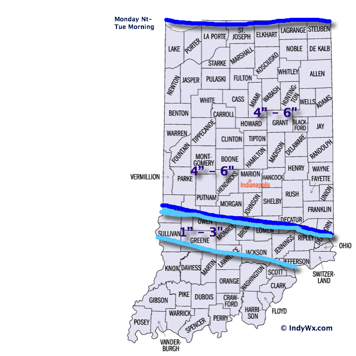
Category: Severe Weather

Late Night Update: Snow Storm Brewing…

Early forecast model data into the office tonight suggests we remain on track for a disruptive widespread snow storm this weekend. We note the timing is speeding up just a…

You must be logged in to view this content. Click Here to become a member of IndyWX.com for full access.  Already a member of IndyWx.com All-Access?  Log-in here.

Permanent link to this article: https://indywx.com/2015/01/29/late-night-update-snow-storm-brewing/

Monday Evening Snowstorm Video Update:

Our going snowfall forecast stands, brought to you by the fine folks at the Indiana Sports Report (indysportsreport.com):

15141614SnowfallForecast2

IndyWx.com was featured on WIBC today with Ray Steele.  You can listen here:

http://www.wibc.com/news/local-news/here-comes-snow-followed-bitter-cold

Permanent link to this article: https://indywx.com/2015/01/05/monday-evening-snowstorm-video-update/

Winter Storm Arrives Tonight…

First, here’s a look at our updated snowfall forecast….we’ve tried “honing in” on where we think banding may set up and create heaviest totals.  As stated last night, snowfall rates…

You must be logged in to view this content. Click Here to become a member of IndyWX.com for full access.  Already a member of IndyWx.com All-Access?  Log-in here.

Permanent link to this article: https://indywx.com/2015/01/05/winter-storm-arrives-tonight/

Monday Night-Tuesday Snow Event: First Call Map

15141614SnowfallForecast

I apologize for the lack of posts today.  My wife and I took time to get away for the weekend before the busy winter weather invades.  As a side note- it takes a special woman to put up with someone like me who has to check each and every model run through the day (and night).  I have an internal clock that causes me to wake up for the European run between 1a – 2a every night this time of year (pathetic, I know).  At any event, here are some of the quick-hitting bullet point highlights of what’s ahead into mid week:

  • Plowable Snow: Snow arrives into central IN by mid to late evening Monday and falls fast and furious for a few hours during the overnight.  Thinking here is that the majority of accumulating snow will fall after the evening rush Monday and before the morning rush Tuesday.  That said, it’ll be tough for snow removal companies and plows to keep up during the heart of the storm as snowfall rates will likely top 1″/hr during the overnight Monday.  Tuesday’s rush to and from work won’t be fun.  The snowfall map above is our best educated idea at this point, but we also think a localized band of 7″ – 8″ totals can’t be ruled out and we’ll use tomorrow to fine tune that band (early thinking is just north of the city).
  • Strong Winds: We’re still expecting wind and cold to become a huge story and concern Tuesday afternoon into mid week.  Northwest winds will become strong and gusty Tuesday and result in considerable blowing and drifting of snow (especially by afternoon).  Travel will likely remain difficult because of the combination of blowing, drifting, and the bitterly cold air.  Wind speeds will top 20-30 MPH Tuesday afternoon and night as the arctic front blows through.
  • Dangerous Cold: Temperatures will plummet Tuesday afternoon as the arctic air hits like a “wall.”  This will set the stage for dangerously cold air Tuesday night through Thursday, including below zero temperatures (5-10 below zero) and wind chill values that approach 30 degrees below zero.  Temperatures Wednesday will struggle to make it much above zero for the high (not a typo).

Permanent link to this article: https://indywx.com/2015/01/04/monday-night-tuesday-snow-event-first-call-map/

Snow Showers Arrive Sunday; More Snow And Dangerous Cold Ahead…

Lots to discuss through the upcoming 7 days so please be sure to click the video and hear our latest thinking.  Have a great Saturday!

You must be logged in to view this content. Click Here to become a member of IndyWX.com for full access.  Already a member of IndyWx.com All-Access?  Log-in here.

Permanent link to this article: https://indywx.com/2015/01/03/snow-showers-arrive-sunday-more-snow-and-dangerous-cold-ahead/

Stretch Of Severe Winter Weather Next Week.

Just wanted to touch on a couple of bullet points for the upcoming week before a more extensive forecast update a bit later this afternoon.  A period of severe winter…

You must be logged in to view this content. Click Here to become a member of IndyWX.com for full access.  Already a member of IndyWx.com All-Access?  Log-in here.

Permanent link to this article: https://indywx.com/2015/01/03/stretch-of-severe-winter-weather-next-week/

Friday Evening Rambles; Busy Winter Pattern…

*Your complete and updated 7-day will be posted later tonight.  As always, please click on the images below to enlarge.

1.) Early freezing rain will give way to a moderate to heavy rain event Saturday.  Widespread 1″-2″ rainfall amounts can be expected.  If traveling during the predawn hours across central Indiana, be aware for possible light glazing from freezing rain.  Forecast radar shows freezing rain potential shortly after midnight.  This should transition to all rain between 2a-4a across central Indiana, but if your travels take you north, northern parts of the state will hang on to a wintry mix a few hours longer.

LgtFRZRain

2.) We’re eyeing an accumulating snow event as a clipper system and associated arctic front blow in Monday night and Tuesday.  Still early to talk specific snow amounts, but it’s the type event that could deposit a “few” inches.  More in the days ahead.  Wind and brutal cold will accompany this snow.

gfs_ptype_slp_conus2_16

3.) Dangerous cold invades next week and reaches coldest levels Wednesday into Thursday. Wind chill values may approach 30 degrees below zero.  Definitely a dangerous scenario if you plan to be outdoors for any length of time period.

WindChill

4.) Additional wintry mischief awaits later next week…

Permanent link to this article: https://indywx.com/2015/01/02/friday-evening-rambles-busy-winter-pattern/

Video Update On Rain To Snow Christmas Eve; More On The Days Ahead…

Good evening, friends!  Here’s an update on our latest thinking Christmas Eve and the coming days…. Have a great night!

You must be logged in to view this content. Click Here to become a member of IndyWX.com for full access.  Already a member of IndyWx.com All-Access?  Log-in here.

Permanent link to this article: https://indywx.com/2014/12/23/video-update-on-rain-to-snow-christmas-eve-more-on-the-days-ahead/

Stormy Times Today; Severe Weather Tonight…

It’s a wet and stormy start for many this morning. Despite some local downpours and embedded thunder, all of this morning’s storms will remain below severe levels. Periods of showers…

You must be logged in to view this content. Click Here to become a member of IndyWX.com for full access.  Already a member of IndyWx.com All-Access?  Log-in here.

Permanent link to this article: https://indywx.com/2014/10/13/stormy-times-today-severe-weather-tonight/

Cool Autumn Weekend; Severe Storm Potential Monday Night…

Sat.

Sun.

Mon.

Tue.

Wed.

Thr.

Fri.

 Status-weather-clouds-icon

 Status-weather-showers-day-icon

 Status-weather-storm-night-icon

 Status-weather-showers-scattered-icon

 Status-weather-clouds-icon

 Status-weather-clouds-icon

 Status-weather-clouds-icon

– –/ 59

42/ 62

56/ 73

55/ 67

52/ 63

51/ 60

50/ 69 

Cool Autumn Weekend…The rest of today will feature mid and high level cloudiness, but dry conditions.  Cool north to northeast winds will blow and require jackets or sweaters if venturing outside for too long of a time.

Be sure to enjoy the brief dry weather Saturday as shower chances return as early as Sunday, particularly during the afternoon hours and on.  Moisture will begin to surge back north in advance of a storm system that will lead to some rough weather around these parts to open the new work week.

Monday Severe Potential…Gusty southwest winds will usher in a warmer and more humid feel of things Monday out ahead of our next strong storm system.  We continue to closely monitor the potential of severe weather Monday night into Tuesday morning and want to highlight the threat of damaging straight line wind potential embedded with a possible squall line.  Beforehand, showers and embedded thunder will be possible during the daytime Monday.

We note the GFS remains consistent on strong to severe storm potential Monday night into Tuesday morning while the European is more delayed (suggesting more of a threat during the day time Tuesday).  For now, we’re leaning more towards the GFS and we’ll have more on the early week severe threat Sunday.  Locally heavy rain is also a good bet during this time, including widespread 1″-1.5″, with locally heavier totals.

Taking The More Optimistic Approach…Some forecast data wants to keep considerable cloudiness and pesky light showers around into the mid week period, but for now we’re still going with the more optimistic outlook and including drier weather along with cooler temperatures for the balance of the upcoming work week.

Upcoming 7-Day Precipitation Forecast:

  • 7-Day Rainfall Forecast: 1-2″
  • 7-Day Snowfall Forecast: 0.00″
hires_ref_ky_61

We continue to highlight Monday night/ Tuesday morning for the potential of severe weather, including damaging straight line winds. Here’s what the high resolution NAM simulated radar suggests at 8p Monday local time.


Permanent link to this article: https://indywx.com/2014/10/11/cool-autumn-weekend-severe-storm-potential-monday-night/

IndyWx.com