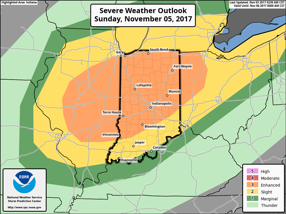
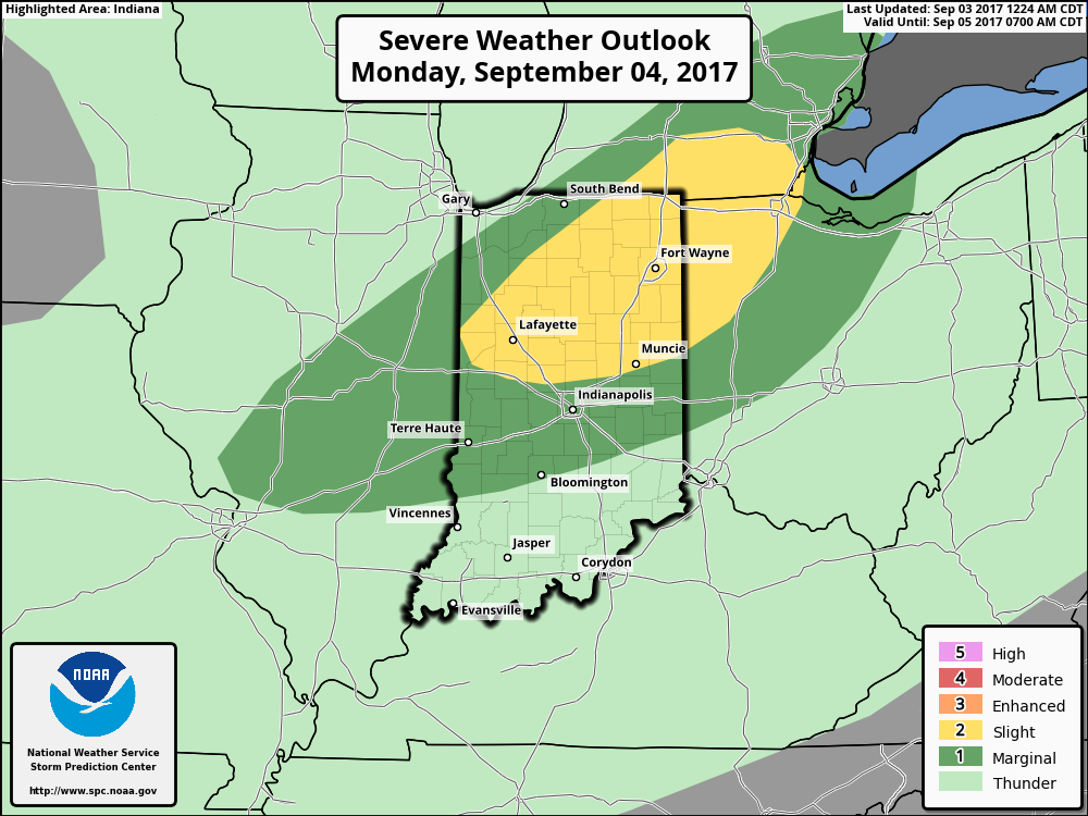
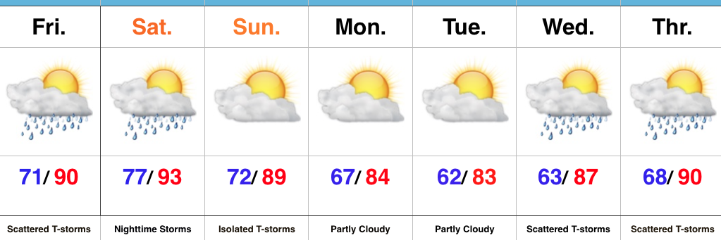
We have growing concerns of a severe weather event Sunday afternoon and evening across the state. This morning, the Storm Prediction Center (SPC) has included most of Indiana in an “Enhanced” risk of severe weather. From this distance, all modes of severe weather seem possible, including large hail, damaging winds, and even a tornado or two.
A trough and associated cold front will slice into an unseasonably warm and increasingly moist air mass Sunday. Ahead of the approaching front, temperatures should climb into the lower 70s Sunday afternoon (average high is in the upper 50s) and dew points will reach the lower to middle 60s. While the developing surface low isn’t expected to be terribly strong, as this feature moves northeast, it’ll help drag a cold front into this warm and increasingly unstable air mass late Sunday. From this distance, conditions seem favorable for a couple of super cells to develop Sunday afternoon and evening. We’ll have to keep a close eye on the northward extent of the warm front as this would be the areas of greatest concern for potential tornadic activity Sunday afternoon. Large hail and damaging winds are also included in Sunday’s severe threat. We’re in the second severe weather season, after all, and this kind of event isn’t unusual. Late November 2013 comes to mind.
It’ll be important to remain weather-aware Sunday and stay tuned all weekend for future updates. We’ll transition to a much cooler regime (back to below average) next week.
A cold front will slice into unseasonably warm and moist air Sunday afternoon and evening. A severe weather episode is a growing concern. Remain weather-aware.
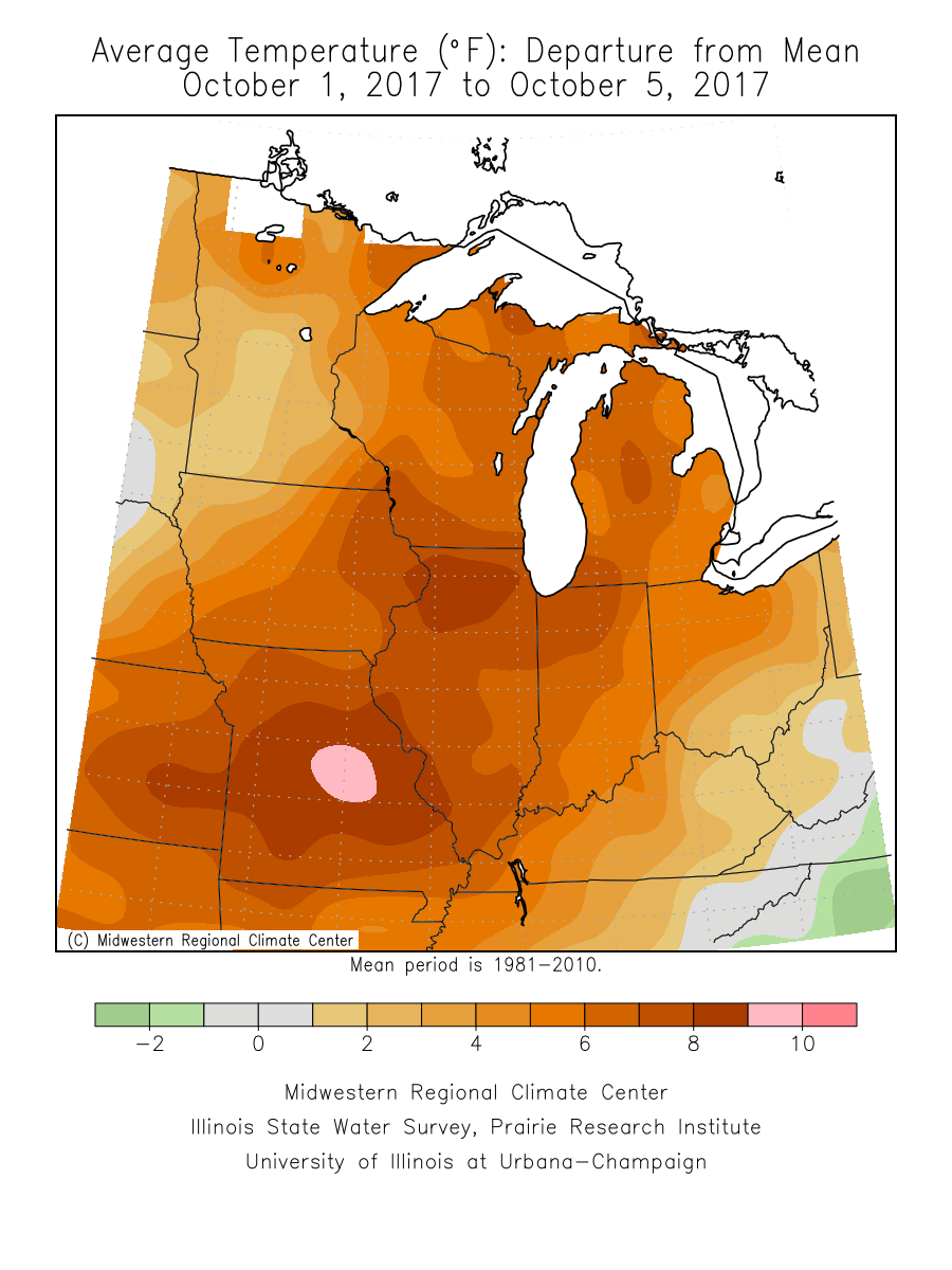
October has gotten off to a warm start (+ 8.4° at IND, to be exact) and that will continue this weekend as high temperatures top out between 80° – 85° Saturday.
October has gotten off to a warm start across the Mid West.
In addition to Saturday’s warmth, southwest winds will gust over 35 MPH at times- especially during the afternoon hours.
Most of Saturday will remain rain free, but we’ll need to keep an eye towards the western horizon Saturday afternoon as a frontal boundary helps kick up a line of thunderstorms.
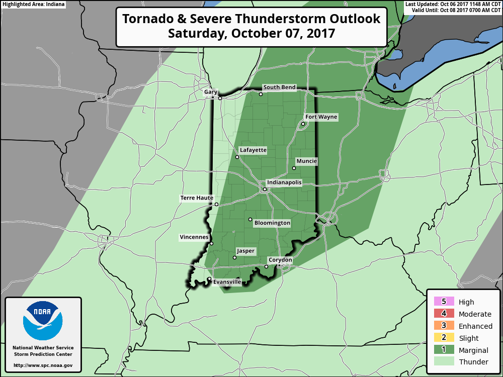
The Storm Prediction Center (SPC) includes a large portion of Indiana under a marginal risk of severe weather Saturday. While widespread severe weather isn’t anticipated, a couple of embedded gusty storms are a good bet Saturday afternoon and evening.
The biggest concern with stronger storms is gusty straight line winds. While the line of storms should be relatively “skinny,” don’t be surprised if one or two of the storms requires a warning. Here’s an idea of what the radar may look like around 9p Saturday.
We’ll turn less humid and slightly cooler for the second half of the weekend!
The Storm Prediction Center includes an Enhanced Risk of severe weather across north-central parts of the state this evening. Damaging winds are of greatest concern with the stronger storms embedded in a squall line that will move from north to south this evening (generally between 6p-midnight).
MUCH cooler air will descend into the region as we progress through the week. Temperatures will be so cool, it’ll feel more like October rather than September, including multiple nights with lows settling into the 40s and highs not making it out of the 60s.
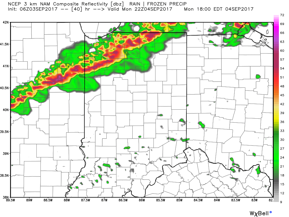
Today will be dry and pleasant and most of Labor Day, itself, will follow suit. We’ll notice an increasingly gusty southwest wind by afternoon and this will help boost temperatures into the upper 80s Monday afternoon.
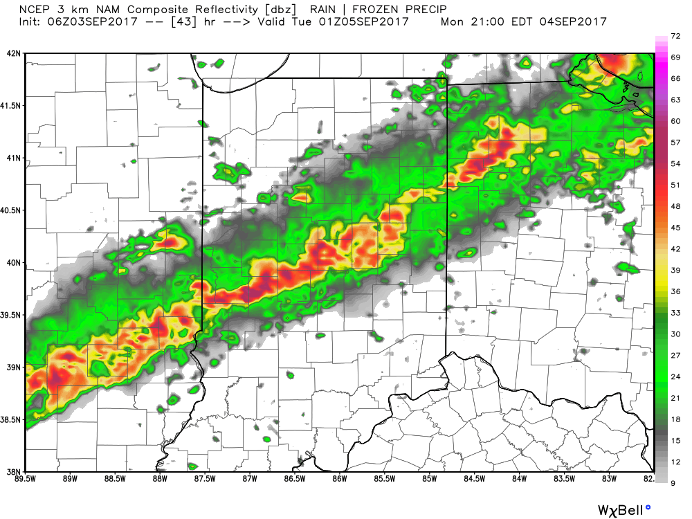
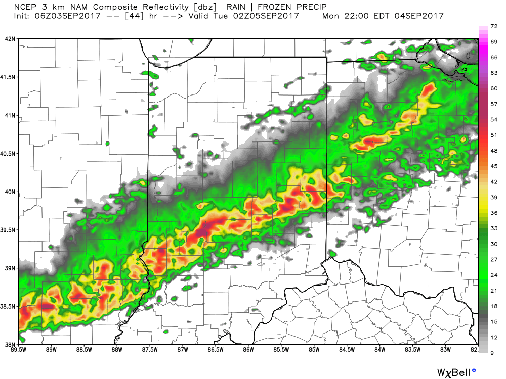
However, once to Labor Day evening, attention will shift off to our north as a line of thunderstorms approaches. A few embedded storms within this line may reach strong-to-severe levels. Damaging straight line winds are of greatest concern with the stronger storms. The Storm Prediction Center has included the region in a Slight Risk of severe weather Monday evening.
After a mostly dry and warm Labor Day, we’ll focus on the evening hours (bracketing 6p-10p) for storms to rumble in. As mentioned, a couple of these could reach strong to severe levels.
6p forecast radar
8p forecast radar
9p forecast radar
10p forecast radar
Once the front blows through, our winds will shift to the northwest and help usher in a much cooler air mass. Average highs in the upper 60s and lows in the upper 40s don’t occur until early-October. We’ll be around 30 days ahead of schedule throughout the majority of the upcoming week, as overnight lows in the upper 40s to around 50 and highs in the upper 60s to around 70 will be common.
You must be logged in to view this content. Click Here to become a member of IndyWX.com for full access. Already a member of IndyWx.com All-Access? Log-in here.
You must be logged in to view this content. Click Here to become a member of IndyWX.com for full access. Already a member of IndyWx.com All-Access? Log-in here.
You must be logged in to view this content. Click Here to become a member of IndyWX.com for full access. Already a member of IndyWx.com All-Access? Log-in here.
Mother Nature Calls…Many awoke early this morning as a complex of thunderstorms rumbled southeast into central Indiana. Some local rain gauges are already registering 2″+ across the region. Eventually, we think clouds will thin enough later today to allow temperatures to zoom close to 90°. Factor in the moisture-rich nature of our air mass and heat indices will approach 105° later this afternoon.
We’ll keep mention of scattered storms this evening and while most of the daytime Saturday looks dry, we’ll have to keep a close eye on Saturday night as models try to deliver another round of storms into central Indiana. Ingredients will be in place for the potential of severe thunderstorms Saturday night, with damaging winds being the biggest concern from a severe perspective.
A frontal boundary will push south and we’ll finally begin to see humidity levels fall as we close the weekend and open next week. It’ll feel very refreshing during the Monday-Tuesday stretch.
Heat, humidity, and storm chances return by the middle of next week.
Storms increase in coverage and intensity this afternoon
More refreshing air arrives for the weekend
Quiet start to next week
Stormy Afternoon On Deck…A frontal boundary will slip into the state today and slowly push south over the next 24 hours, eventually making it out of the state Friday. The combination of this trigger (front) along with a genuinely “soupy” air mass (precipitable water values will be north of 2″ and dew points will remain in the low-mid 70s) will result in increasing storm coverage this afternoon into the evening hours. Some of the storms may become severe and it also won’t take much for flash flooding to develop where storms train. In some cases, these storms will dump rainfall rates of 2″-3″/ hour. From a severe stand point, we’re most concerned for the potential of damaging straight line winds.
Thankfully, we’ll clear things out in time for the upcoming weekend. With the exception of a few morning thunderstorms downstate Friday, the trend will be a drier one and that will continue into Saturday. Along with the drier air, we’ll also note slightly cooler temperatures. It’ll feel much more refreshing than the past couple days.
A weak reinforcing cold front will sweep through the state Sunday evening and this boundary could kick-up a scattered thunderstorm or two Sunday afternoon-evening before we return to dry times Monday and Tuesday. Moisture (and heat) will return by the middle of next week.
Tuesday and Thursday appear to be the stormiest days
Drier trend to close the week; open the weekend
Humid air gives way to a more refreshing feel
Stormy Periods…Storms are building across west-central Indiana this morning and these will settle into the city, itself, as the rush hour nears. This is only the beginning of multiple rounds of thunderstorms that will ride in a northwest to southeast fashion across central Indiana today. With dew points in the lower and middle 70s and precipitable water values exceeding 2″, additional flash flooding will result today for some communities where storms “train” over the same areas. A couple of strong-to-severe storms are also possible this afternoon with large hail and damaging straight line winds the biggest concern.
While we can’t rule out a passing storm Wednesday, overall storm coverage should be significantly reduced tomorrow as we get in on bit of a breather before another active time of things Thursday.
A surface front will settle south Friday. Best thunderstorm chances should occur during the front half of the day before a drier regime builds in from the north Friday evening and into Saturday. Temperatures will cool slightly, but we’ll really be able to notice a dramatic reduction in the humidity.
Sunday should be mostly dry, but we note a weak secondary boundary that will pass late in the day. This may be just enough to kick up a shower or thunderstorm Sunday afternoon or evening.

 A trough and associated cold front will slice into an unseasonably warm and increasingly moist air mass Sunday. Ahead of the approaching front, temperatures should climb into the lower 70s Sunday afternoon (average high is in the upper 50s) and dew points will reach the lower to middle 60s. While the developing surface low isn’t expected to be terribly strong, as this feature moves northeast, it’ll help drag a cold front into this warm and increasingly unstable air mass late Sunday. From this distance, conditions seem favorable for a couple of super cells to develop Sunday afternoon and evening. We’ll have to keep a close eye on the northward extent of the warm front as this would be the areas of greatest concern for potential tornadic activity Sunday afternoon. Large hail and damaging winds are also included in Sunday’s severe threat. We’re in the second severe weather season, after all, and this kind of event isn’t unusual. Late November 2013 comes to mind.
 The biggest concern with stronger storms is gusty straight line winds. While the line of storms should be relatively “skinny,” don’t be surprised if one or two of the storms requires a warning. Here’s an idea of what the radar may look like around 9p Saturday.
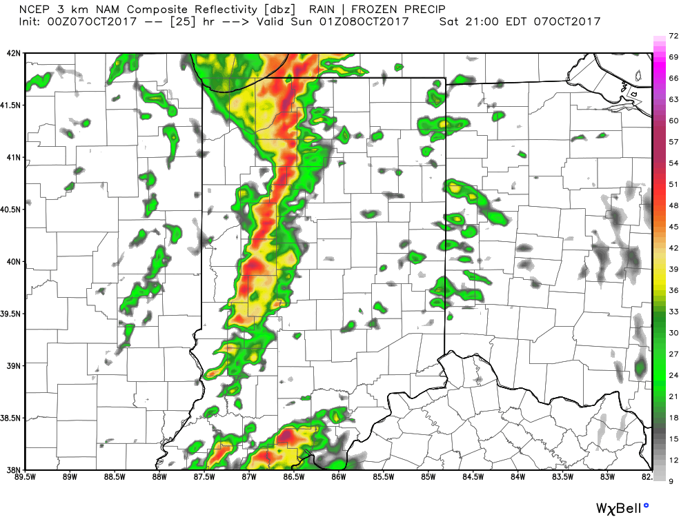 We’ll turn less humid and slightly cooler for the second half of the weekend!
 MUCH cooler air will descend into the region as we progress through the week. Temperatures will be so cool, it’ll feel more like October rather than September, including multiple nights with lows settling into the 40s and highs not making it out of the 60s.
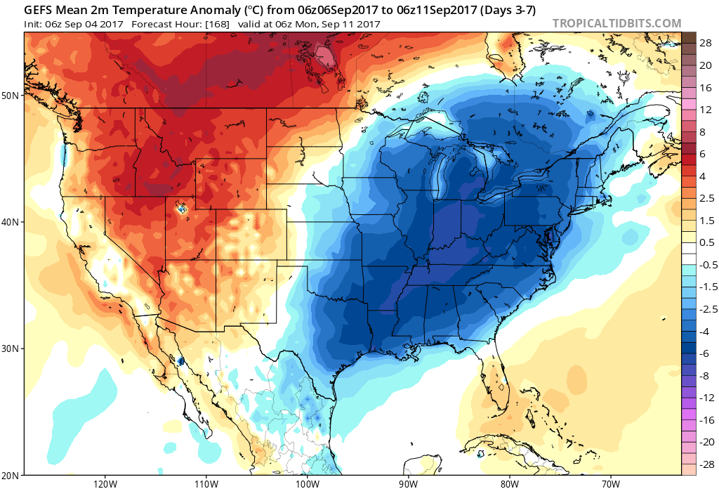


 Highlights:
 Highlights:
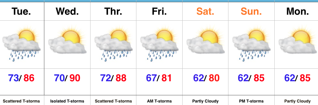 Highlights: