You must be logged in to view this content. Click Here to become a member of IndyWX.com for full access. Already a member of IndyWx.com All-Access? Log-in here.
Category: Severe Weather
Permanent link to this article: https://indywx.com/2019/06/18/video-latest-thoughts-on-tomorrows-severe-potential-and-looking-ahead-through-the-1st-half-of-july/
Jun 18
VIDEO: Severe Threat Continues To Increase Wednesday PM…
You must be logged in to view this content. Click Here to become a member of IndyWX.com for full access. Already a member of IndyWx.com All-Access? Log-in here.
Permanent link to this article: https://indywx.com/2019/06/18/video-severe-threat-continues-to-increase-wednesday-pm/
Jun 17
Only Going To Get Worse Before It Gets Better…
The pattern into the medium range period continues to look like a broken record: excessively wet. Unfortunately, flood and flash flood warnings will continue to likely be issued over the next 7-10 days on an almost daily basis for at least portions of the immediate viewing area.
Current Flash Flood Guidance can be found below:

In most cases across central and southern Indiana, we’re only talking about rainfall of 1″ to 1.5″ in an hour’s timeframe that will cause flash flooding. 3 hour guidance is in the 1.5″ to 2″ range.
Tuesday will feature less overall aerial coverage of showers and thunderstorms (widely scattered) as compared to the past few days. However, we’re tracking (2) surface waves that will result in more widespread heavy rain and thunderstorms Wednesday afternoon into Thursday and again over the weekend into early next week with a moisture-rich, tropical southwesterly air flow in place.
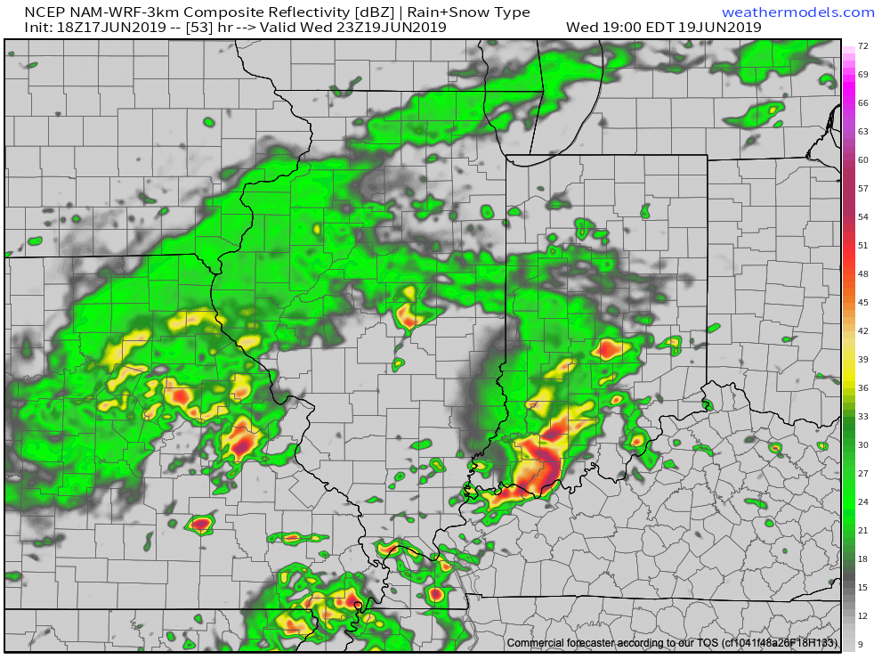
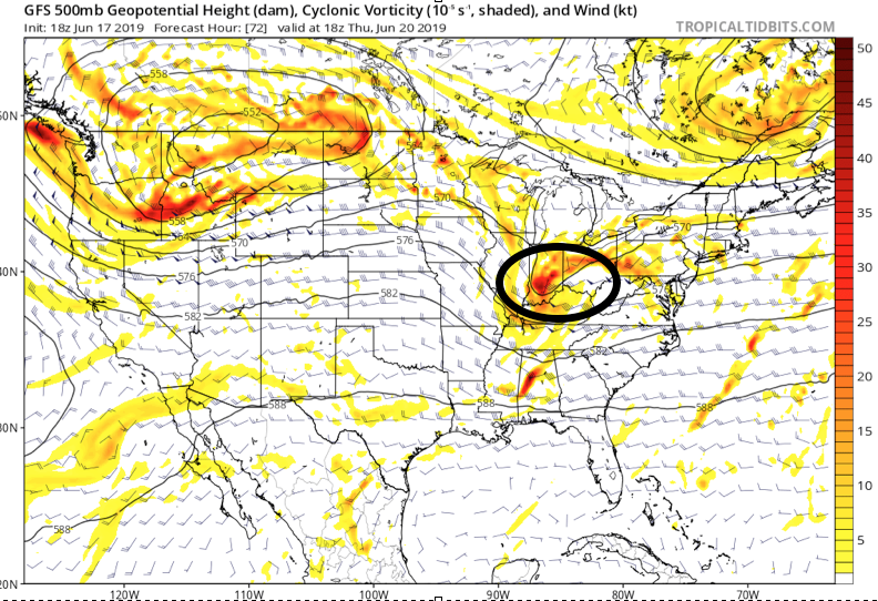
As mentioned above, severe weather is possible Wednesday afternoon and evening as vigorous upper level energy accompanies the surface wave scooting across the lower OHV. This will warrant our attention over the upcoming 48 hours and will likely lead to the Storm Prediction Center expanding the current Slight Risk further northwest with future updates.
Fingers are still crossed for briefly drier conditions Friday before we reload the moisture with a persistent southwesterly air flow this weekend. This will promote additional concerns for heavy rainfall over the weekend.
At times, this moist southwest flow will help precipitable water values exceed 2″. Needless to say, concern will remain very high for additional flooding problems over the weekend into early next week.
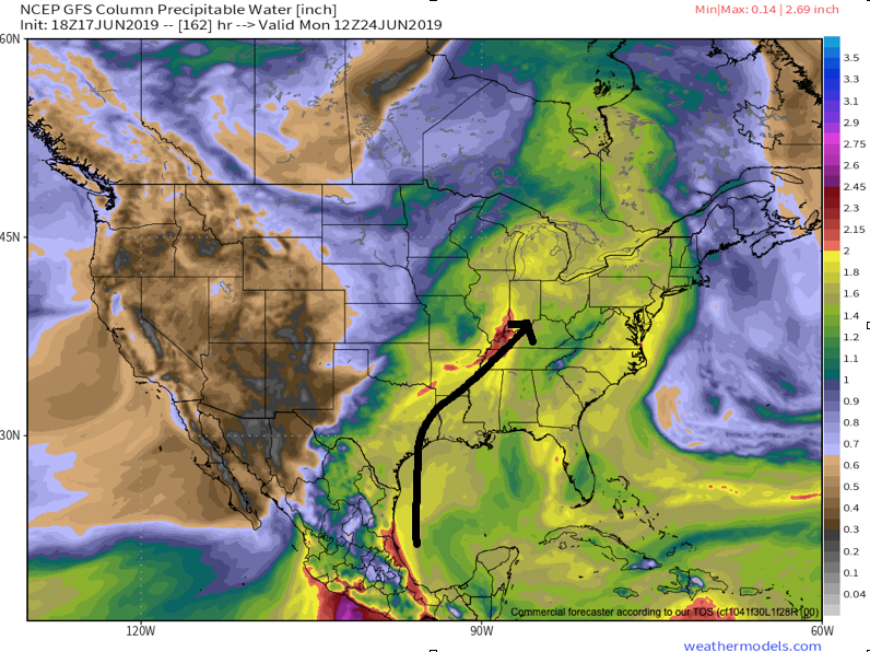
Widespread additional rainfall of 2.5″ to 3.5″ is a good bet with locally heavier amounts over the upcoming week.
More on the long range pattern into the Weeks 3/4 period tomorrow!
Permanent link to this article: https://indywx.com/2019/06/17/only-going-to-get-worse-before-it-gets-better/
Jun 17
VIDEO: A New Week; Same Ole Weather Pattern. Discussing The Pattern Evolution Into July…
You must be logged in to view this content. Click Here to become a member of IndyWX.com for full access. Already a member of IndyWx.com All-Access? Log-in here.
Permanent link to this article: https://indywx.com/2019/06/17/video-a-new-week-same-ole-weather-pattern-discussing-the-pattern-evolution-into-july/
Jun 16
Weekly #AGwx And Severe Weather Outlook…
Forecast period: 06.17.19 through 06.24.19
7-Day Precipitation: Rainfall is expected to run above average through the period.

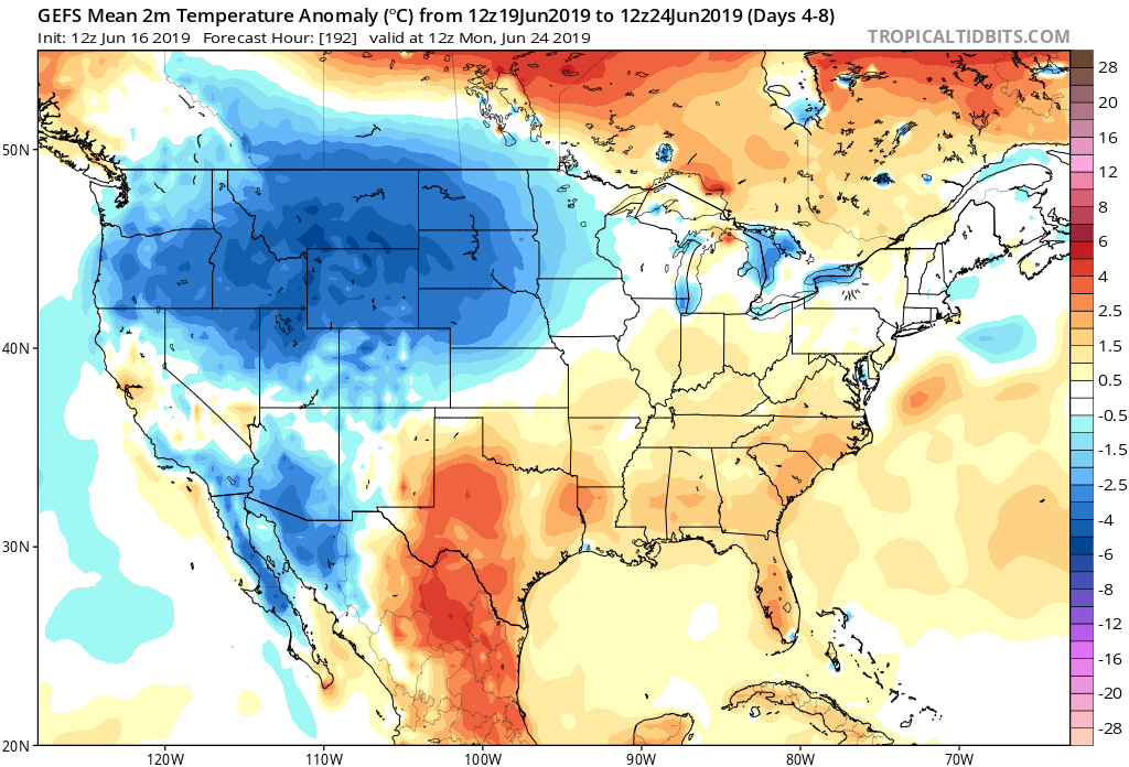
7-Day Temperature Outlook: Temperatures are expected to run slightly above normal through the period- mostly thanks to the warmer than average overnight lows with all of the expected clouds/ moisture present.
Severe Outlook: We’ll remain on guard for the potential of scattered strong to severe thunderstorms through the period- likely most numerous during times where surface waves interact with nearby warm fronts (case in point, Saturday). Most common severe weather reports will likely come from large hail and damaging winds, but a tornado or two can’t be ruled out during the period- especially with a couple of warm fronts draped across central Indiana.
Busiest severe weather days over the upcoming week will likely include Monday, Wednesday into Thursday, and next Saturday into Sunday.
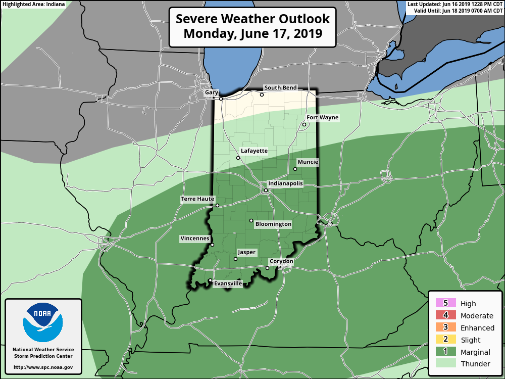
Summary: An active weather pattern will remain in place across central Indiana through the upcoming forecast period. A blend of latest computer models puts down an additional 4.1″ across a widespread portion of central Indiana and most of that will fall within the upcoming 7 days. There will be locally heavier totals. Without trying to “sensationalize” the upcoming forecast period, flood and flash flood events will remain in place- and at times may become significant.
As mentioned earlier this morning, the hope here is that we can squeeze out a 2-3 day dry period late June before a stormy pattern returns for early July. Fingers are crossed…
Permanent link to this article: https://indywx.com/2019/06/16/weekly-agwx-and-severe-weather-outlook-3/
Jun 16
VIDEO: A Very Wet Week Is On Deck; Early July Thoughts…
You must be logged in to view this content. Click Here to become a member of IndyWX.com for full access. Already a member of IndyWx.com All-Access? Log-in here.
Permanent link to this article: https://indywx.com/2019/06/16/video-a-very-wet-week-is-on-deck-early-july-thoughts/
Jun 15
VIDEO: Classic Pattern For A Significant Flood Event…
You must be logged in to view this content. Click Here to become a member of IndyWX.com for full access. Already a member of IndyWx.com All-Access? Log-in here.
Permanent link to this article: https://indywx.com/2019/06/15/video-classic-pattern-for-a-significant-flood-event/
Jun 14
Friday Evening All-Access Video Update: A Wet, Stormy Weekend Awaits…
You must be logged in to view this content. Click Here to become a member of IndyWX.com for full access. Already a member of IndyWx.com All-Access? Log-in here.
Permanent link to this article: https://indywx.com/2019/06/14/friday-evening-all-access-video-update-a-wet-stormy-weekend-awaits/
Jun 13
VIDEO: Fall-Like Close To The Work Week Gives Way To An Unsettled Weekend; Reviewing Updated Data Into The Fall…
You must be logged in to view this content. Click Here to become a member of IndyWX.com for full access. Already a member of IndyWx.com All-Access? Log-in here.
Permanent link to this article: https://indywx.com/2019/06/13/video-fall-like-close-to-the-work-week-gives-way-to-an-unsettled-weekend-reviewing-updated-data-into-the-fall/
Jun 10
Weekly #AGwx And Severe Weather Outlook…
Forecast period: 06.10.19 through 06.17.19
7-Day Precipitation: Rainfall is expected to run above average through the period.

7-Day Temperature Outlook: Temperatures are expected to run well below average through the period.
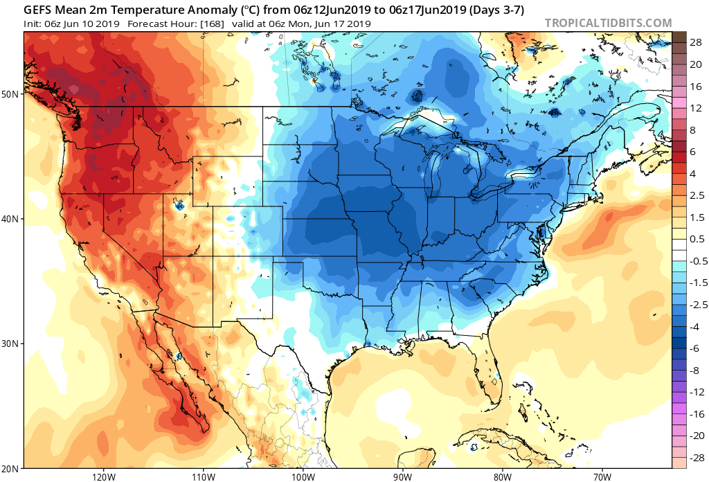
Severe Outlook: Widespread severe weather isn’t anticipated through the period. With that said, we’ll keep an eye on the potential of a couple gusty storms Wednesday as vigorous upper level energy and an associated cold front blow through the state.
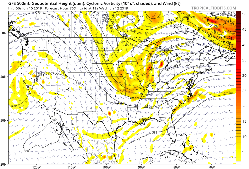
Summary: After a wet close to the weekend, drier air will return today and Tuesday, along with increasing sunshine from west to east by this afternoon. Our next system of note arrives Wednesday in the form of a cold front. This will serve to reinforce the unseasonably cool air in place across the region for late week, but also may provide a few gusty storms as it moves through the area. Shower coverage will be scattered to widespread Wednesday. Another system will approach over the weekend with unsettled conditions expected both Saturday and Sunday.
While temperatures will run below normal throughout the period, the coolest day of the week appears to be Thursday with highs only in the mid to upper 60s and lows in the upper 40s to lower 50s.
Permanent link to this article: https://indywx.com/2019/06/10/weekly-agwx-and-severe-weather-outlook-2/
