
You must be logged in to view this content. Click Here to become a member of IndyWX.com for full access. Already a member of IndyWx.com All-Access? Log-in here.
Category: Severe Weather
Permanent link to this article: https://indywx.com/2019/09/03/video-watching-for-storms-tonight-then-a-quiet-cooler-rest-of-the-week/
Sep 02
Weekly AG And Severe Weather Update…
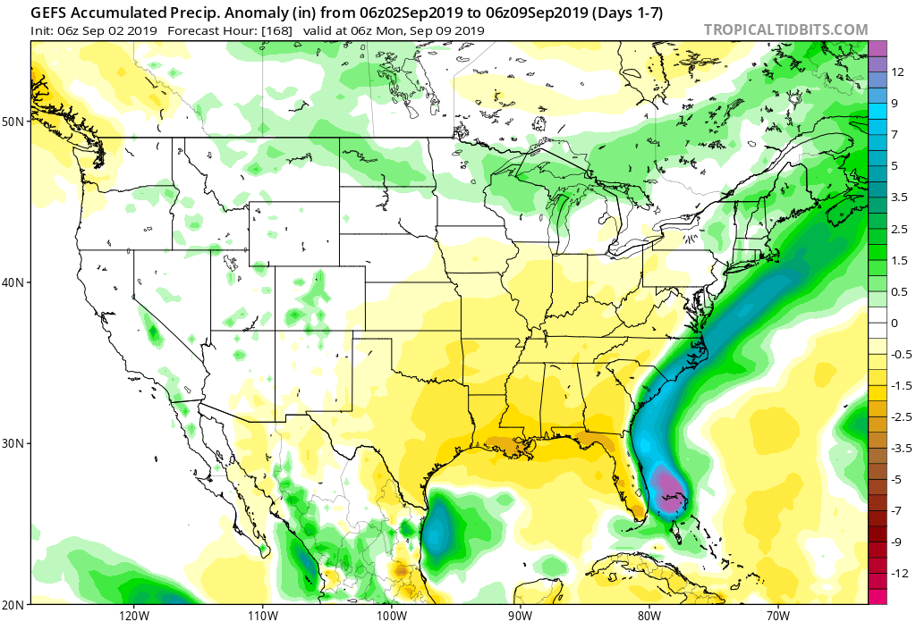
Forecast period: 09.02.19 through 09.09.19
7-Day Precipitation: Precipitation is expected to run well below normal through the forecast period.
7-Day Temperatures: Temperatures are expected to run below average through the forecast period overall.

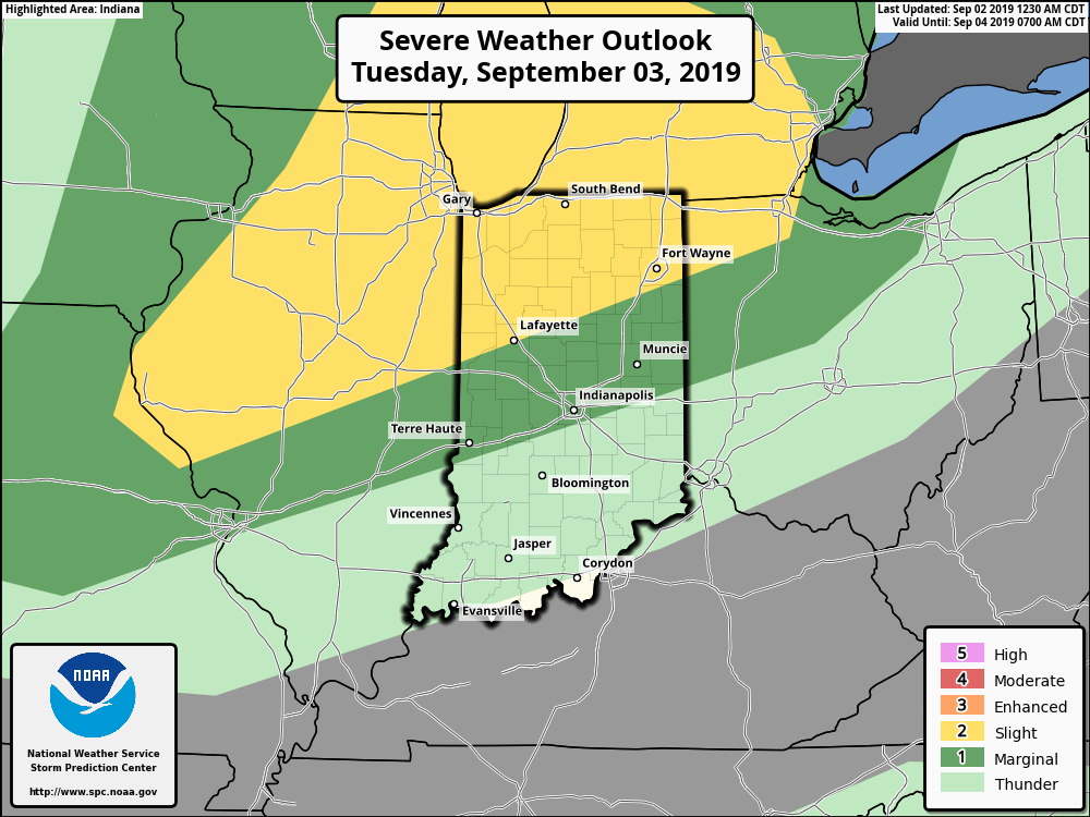
Severe Weather Outlook: In what will be a quiet period, overall, we’ll keep an eye to our north Tuesday evening. The reason? A cold front will push south and a line of strong to severe thunderstorms is expected to develop across northern Indiana tomorrow evening. Damaging wind is the greatest concern with storms across northern parts of the state. As the front continues to settle south, thunderstorms will weaken as they push into central Indiana between 8p and midnight. Otherwise, severe weather isn’t expected through the period.
Summary: The upcoming 7-days will be dominated by an overall cooler and drier than normal theme than we’d come to normally expect for early September. A couple of cold fronts will sweep through the state this week: Tuesday night and again Saturday. While there isn’t a lot of fanfare expected with these fronts from a precipitation perspective, they will serve to offer up a true fall-like feel mid week into the weekend. We’ll keep an eye on thunderstorms across northern IN Tuesday PM, but still expect these to be in a weakening state as they arrive into central parts of the state tomorrow night.
Permanent link to this article: https://indywx.com/2019/09/02/weekly-ag-and-severe-weather-update-5/
Aug 20
VIDEO: Severe Storm Threat Later This Afternoon; Reinforcing Cool Period Around Labor Day, And More Winter Chatter…
You must be logged in to view this content. Click Here to become a member of IndyWX.com for full access. Already a member of IndyWx.com All-Access? Log-in here.
Permanent link to this article: https://indywx.com/2019/08/20/video-severe-storm-threat-later-this-afternoon-reinforcing-cool-period-around-labor-day-and-more-winter-chatter/
Aug 18
Weekly AG And Severe Weather Update…
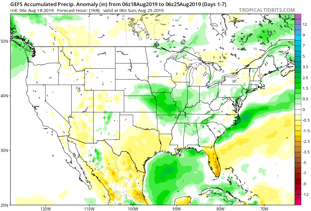
Forecast period: 08.18.19 through 08.25.19
7-Day Precipitation: Rainfall is expected to run near average through the forecast period. We’re forecasting widespread 0.50″ to 1″ amounts to be common across central Indiana, but there will be locally heavier amounts where strong storms track.
7-Day Temperature Outlook: Temperatures are expected to run near average through the forecast period- balanced by a warmer than normal open to the period and cooler than average close.
Severe Weather Outlook: An active weather pattern will remain with us through the 1st half of the new week. In addition to the threat of severe weather today, we’re also closely monitoring the potential of strong to severe storms Tuesday night-Wednesday as a cold front slices into the hot and humid air mass in place. The pattern will turn much calmer once we get to the 2nd half of the week as cooler, drier air builds in.
Day 1: After a quiet start to our Sunday, a line of thunderstorms is expected to form to our northwest this afternoon. That line should move southeast and begin to impact central Indiana late afternoon into the early evening hours. Some of the stronger cells will promote the chance of large hail and damaging straight line winds.

Day 3: Scattered thunderstorms will remain in the forecast Monday, but widespread severe weather isn’t anticipated. As we look ahead, a cold front will slice into the hot and humid air mass in place across the Ohio Valley Tuesday night into Wednesday. As you might expect, the clash of air masses between significantly cooler and drier air behind the boundary will lead to scattered to numerous storms during the transition. Accordingly, we’ll need to remain on guard for the threat of additional severe weather (threats similar to that of today) during that time frame before much quieter, calmer weather takes over Wednesday night into next weekend.
Permanent link to this article: https://indywx.com/2019/08/18/weekly-ag-and-severe-weather-update-4/
Aug 17
VIDEO: Weekend Update And More EPO Talk…
You must be logged in to view this content. Click Here to become a member of IndyWX.com for full access. Already a member of IndyWx.com All-Access? Log-in here.
Permanent link to this article: https://indywx.com/2019/08/17/video-weekend-update-and-more-epo-talk/
Aug 13
VIDEO: Trending Less Humid For Mid-Late Week; Consistency Developing In The Medium Range…
You must be logged in to view this content. Click Here to become a member of IndyWX.com for full access. Already a member of IndyWx.com All-Access? Log-in here.
Permanent link to this article: https://indywx.com/2019/08/13/video-trending-less-humid-for-mid-late-week-consistency-developing-in-the-medium-range/
Aug 12
VIDEO: Severe Weather Event Tonight; A Lot Of “Noise” With Regard To The Late August Pattern…
You must be logged in to view this content. Click Here to become a member of IndyWX.com for full access. Already a member of IndyWx.com All-Access? Log-in here.
Permanent link to this article: https://indywx.com/2019/08/12/video-severe-weather-event-tonight-a-lot-of-noise-with-regard-to-the-late-august-pattern/
Aug 12
Storm Chances Increase Tonight…
A few showers are on the radar this morning, but it’s late tonight through very early Tuesday morning that has our attention for the possibility of severe weather.
The Storm Prediction Center continues to include a large chunk of the state in a Slight Risk of severe weather.

Storms are expected to initiate across eastern Iowa and northwestern Illinois late evening (between 6p and 8p) before rumbling east southeast.
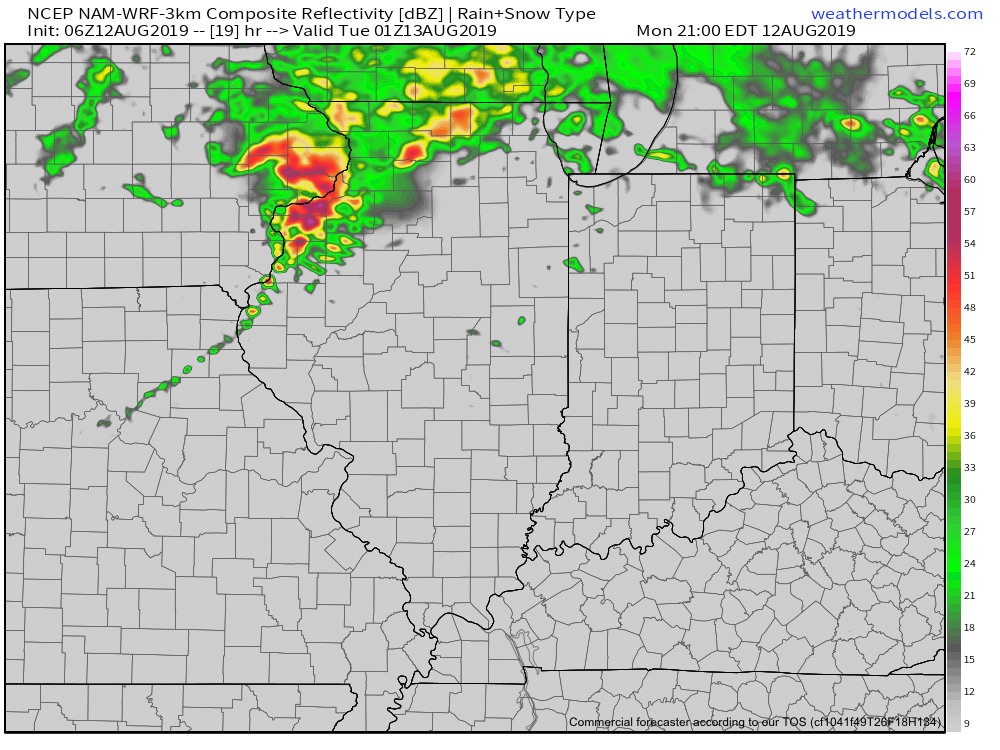
Given the ingredients in place, all modes of severe weather are possible into the overnight, but it’s the potential of damaging straight line winds that is the greatest by the time the storms make it into central Indiana. (Targeting an arrival between 1a and 3a).
We’ll have a video posted early this evening with some of our latest thoughts and most updated high resolution guidance. As things stand now, we’d encourage you to make sure you have a means of getting the latest severe weather headlines that may come later tonight. It’ll be important to set your weather radio alerts to “on” as it’s most likely the storms will arrive when the majority of folks are sleeping.
Much more later this evening!
Permanent link to this article: https://indywx.com/2019/08/12/storm-chances-increase-tonight/
Aug 11
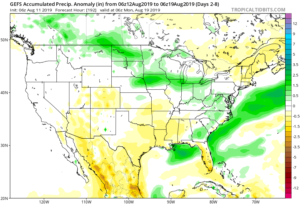
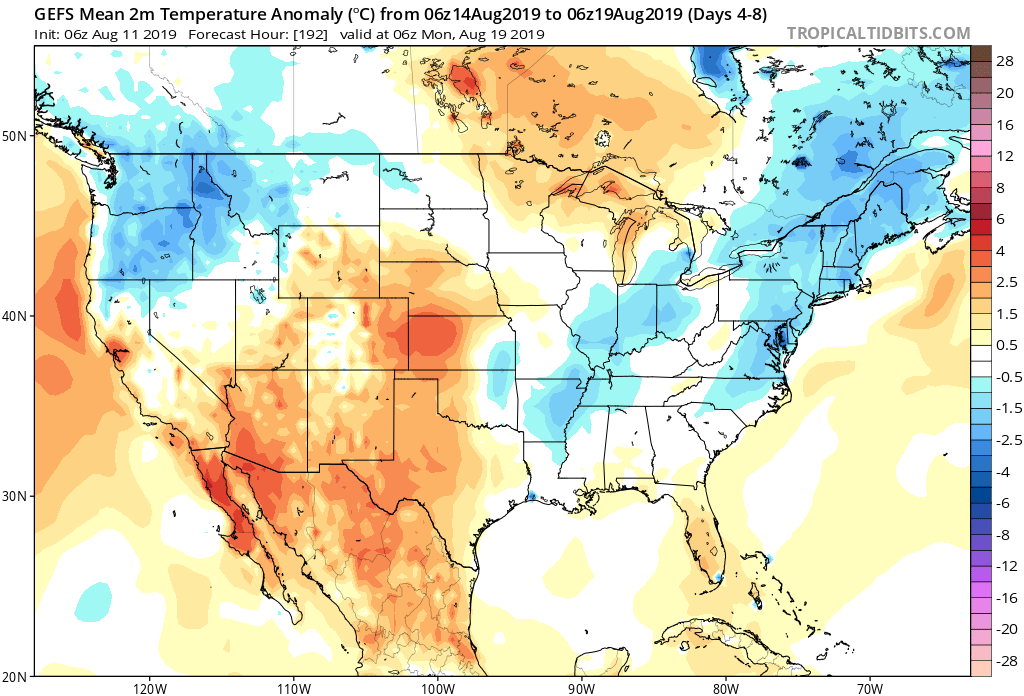
Weekly AG And Severe Weather Update…
Forecast period: 08.12.19 through 08.19.19
7-Day Precipitation: Rainfall is expected to run near average through the forecast period.
7-Day Temperatures: Temperatures are expected to run near seasonal levels through the period.
Severe Outlook: Severe weather is expected across central Indiana as we open the work week. All modes of severe weather are possible including large hail, damaging winds, and a couple of tornadoes.

Summary: The forecast period will open up on an active note as a rather potent surface wave scoots across the southern Great Lakes region. A complex of thunderstorms is expected to organize across IA and IL Monday afternoon before pushing east southeast Monday evening. Accordingly, chances of strong to severe thunderstorms along with locally heavy rain will be on the increase Monday evening into very early Tuesday across central Indiana, including Indianapolis. Several favorable ingredients are coming together to produce the threat of severe weather, including large hail, damaging wind, and potentially a couple of tornadoes. On average, between 0.50″ and 1″ of rain is expected with this system, however, if thunderstorms “train” over the same communities tomorrow night, amounts will be much higher in localized areas.
Thereafter, weather conditions will quiet down as we move into the middle and latter portions of the work week. While heat and humidity will build to our southwest, immediate central Indiana shouldn’t have to deal with much in the way of excessive heat/ humidity through the forecast period with seasonal temperatures expected around our part of the state much of the week.
Permanent link to this article: https://indywx.com/2019/08/11/weekly-ag-and-severe-weather-update-3/
Aug 10
VIDEO: Gorgeous Weekend Weather; Keeping Close Tabs On Monday PM North…
You must be logged in to view this content. Click Here to become a member of IndyWX.com for full access. Already a member of IndyWx.com All-Access? Log-in here.
Permanent link to this article: https://indywx.com/2019/08/10/video-gorgeous-weekend-weather-keeping-close-tabs-on-monday-pm-north/