Periods Of Storms; BIG Push Of Chilly Air On The Way…
|
Thr. |
Fri. |
Sat. |
Sun. |
Mon. |
Tue. |
Wed. |
|
|
|
|
|
|
|
|
|
61/ 83 |
46/ 70 |
43/ 49 |
40/ 57 |
44/ 64 |
49/ 64 |
48/ 70 |
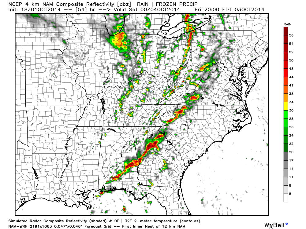
Changes…BIG weather changes begin today as a warm front lifts through the region. This will lead to a warm and windy afternoon with showers and a possible rumble of thunder arriving as early as the morning rush. Periods of showers and thunderstorms will continue this afternoon and evening, but we also want to note there will be plenty of dry time in between rain drops. A bigger push of showers and thunderstorms will blow into town tonight into the wee morning hours Friday. A couple of these storms may reach severe levels, especially for western communities. Damaging straight line winds are the biggest concern.
Showers and thunderstorms continue Friday, but the bigger weather story will become our temperatures as a MUCH colder air mass rushes into the area Friday evening on a gusty northwest wind. Falling temperatures can be expected through the afternoon Friday so you’ll want to be sure to pack the jacket and cold weather gear tomorrow.
Chilly Weekend…Well below normal temperatures can be expected this weekend along with unsettled conditions. Saturday continues to look like a mostly cloudy and blustery day with periods of drizzle and/ or sprinkles. Sunday will feature more in the way of sunshine, but caution we may also deal with widely scattered light showers.
Timing Issues…We’ll fine tune early next week once our first storm system moves through the region. As of now, we target Tuesday as the best day of showers, but timing issues abound. More on this later.
Upcoming 7-Day Precipitation Forecast
- 7-Day Rainfall Forecast: 1″ – 1.50″
- 7-Day Snowfall Forecast: 0.00″
John Salewicz sent in this great sunset photo on the Carmel/ Zionsville line Wednesday evening. Thanks, John!