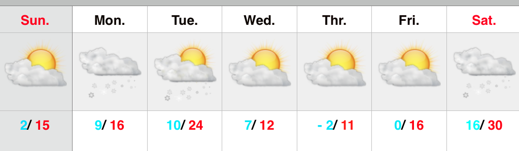
Category: Severe Weather

Gearing Up For A Busy Weather Week…

Sun.

Mon.

Tue.

Wed.

Thr.

Fri.

Sat.

 Status-weather-clouds-icon

 Status-weather-clouds-icon

 Status-weather-showers-day-icon

 Status-weather-storm-night-icon

 Status-weather-showers-day-icon

 Status-weather-clouds-icon

 Status-weather-clouds-icon

54/ 75

53/ 78

52/ 81

63/ 85

58/ 71

50/ 65

45/ 64 

Beautiful Close To The Weekend…Canadian high pressure will supply plentiful sunshine and pleasantly cool temperatures as we close out the weekend.  Even though today is the first Sunday to the NFL season, we’d suggest finding a way to watch your favorite game outside.

Lots of sunshine and mild temperatures continue Monday.

Mid Week Heavy Rain And Storms…A warm front will move north through central Indiana Tuesday and supply an increasingly humid feel to our air mass.  As the warm front lifts north, a couple showers or isolated thunderstorms will be possible Tuesday afternoon/ evening.  Most communities should remain rain-free, however.

Much better chances of showers and thunderstorms will arrive Wednesday as an area of low pressure and associated strong cold front impact the state.  Some of the storms could reach severe levels and locally heavy rainfall is also a good bet.  Stay tuned.

Bring Out The Jackets…A big push of unseasonably chilly air will blow into town as we wrap up the work week and head into next weekend. Well below normal temperatures will combine with sunny skies to create a classic fall weekend.  May not be a bad idea to plan on a pot of chili at some point next weekend… Just sayin’!

7-Day Precipitation Forecast:

  • 7-Day Rainfall Forecast: 1.5″ – 2″
  • 7-Day Snowfall Forecast: 0.00″

A little rain didn’t dampen the spirit of those in the Zionsville Fall Festival parade Saturday.  Thanks to John Salewicz for the photo!

Bw5HntqCAAAv0VI.jpg-large


D6

Craving some truly chilly autumn air? Hang in there for late week. Well below normal temperatures (more like October levels) will blow into town later this week.

Permanent link to this article: https://indywx.com/gearing-up-for-a-busy-weather-week/

Couple Dry Days Ahead Of Friday Storms; Weekend Cool Down…

Wed.

Thr.

Fri.

Sat.

Sun.

Mon.

Tue.

 Status-weather-clouds-icon

 Status-weather-clouds-icon

 Status-weather-showers-day-icon

 Status-weather-showers-day-icon

 Status-weather-clouds-icon

 Status-weather-clouds-icon

 Status-weather-showers-day-icon

63/ 84

62/ 87

67/ 89

58/ 73

51/ 74

51/ 75

56/ 79 

Dry Time…Sun-filled days can be expected after morning fog burns off across outlying areas both today and Thursday.  Temperatures will be a touch above normal.

Friday Night Storms Ahead Of Big Cool Down…A cold front will pass the state early Saturday.  Ahead of this front, a line of strong to severe storms will be possible Friday night.  We’ll fine tune timing as we progress through the next day or two.  A blast of much cooler, drier air will then pour into the state over the weekend.  It’ll feel very much like fall around these parts…

Next Rain Maker…We’ll enjoy another dry and seasonably cool couple days before our next potentially significant rain maker gears up for the middle of next week.  Both the GFS and European forecast models are hinting this could be a significant rain maker, but caution this is still early and fine tuning will be required.

7-Day Precipitation Forecast:

  • 7-Day Rainfall Forecast: 0.50″ – 1.00″
  • 7-Day Snowfall Forecast: 0.00″

Farmer Paul of Full Circle Farm sent in this beautiful fog bank shot this morning.  Full Circle Farm is located across southern Boone County in Whitestown.  We encourage you to check out their web site if you haven’t already.  Thanks, Paul!

BwmoKzlIEAAPEAN


Permanent link to this article: https://indywx.com/couple-dry-days-ahead-of-friday-storms-weekend-cool-down/

Another Couple Rounds Of Storms…

Tonight’s video covers what’s likely to be another couple rounds of showers and thunderstorms that move through the region and provide embedded severe and locally heavy rain. PWAT values reach…

You must be logged in to view this content. Click Here to become a member of IndyWX.com for full access.  Already a member of IndyWx.com All-Access?  Log-in here.

Permanent link to this article: https://indywx.com/another-couple-rounds-of-storms/

Storms And Heat…

Good morning and happy Thursday! This will be a quick post this morning before a more extensive update and 7-day outlook later this evening. The SPC highlights our region for…

You must be logged in to view this content. Click Here to become a member of IndyWX.com for full access.  Already a member of IndyWx.com All-Access?  Log-in here.

Permanent link to this article: https://indywx.com/storms-and-heat/

Strong To Severe Storms, Big Heat, And Tropics!

Highlights of tonight’s video: Strong to severe storms Active pattern continues Serious weekend heat Tropics turn active PS: We continue to experience technical issues with a slight lag on audio/…

You must be logged in to view this content. Click Here to become a member of IndyWX.com for full access.  Already a member of IndyWx.com All-Access?  Log-in here.

Permanent link to this article: https://indywx.com/strong-to-severe-storms-big-heat-and-tropics/