VIDEO: Not Bad For Race Day, But Storms May Threaten This Afternoon In Spots…
You must be logged in to view this content. Click Here to become a member of IndyWX.com for full access. Already a member of IndyWx.com All-Access? Log-in here.
You must be logged in to view this content. Click Here to become a member of IndyWX.com for full access. Already a member of IndyWx.com All-Access? Log-in here.
As the race weekend and Memorial Day draw ever-closer, data is able to pick up on some of the specifics associated with our weather for the all-important long weekend.
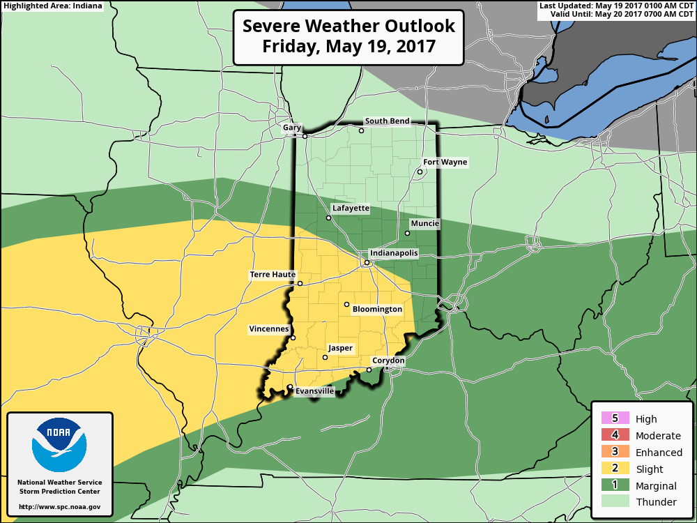
After scrolling through the data this evening, it appears as if we need to bracket late Friday night-Saturday morning and again late Saturday into Sunday morning for the potential of two rounds of gusty storms. Some of these storms could reach strong to severe levels, and the Storm Prediction Center continues to outline central Indiana for a Slight Risk Saturday (large hail and damaging straight line winds are of greatest concern, locally).
 Despite having to dodge a couple rounds of gusty storms this weekend, we want to stress that the majority of the holiday weekend should feature rain-free hours, and certainly isn’t worth cancelling any outdoor plans. In fact, after a beautiful Carb Day, most of the daytime hours both Saturday and Sunday should be rain and storm free. Have a means of getting the latest weather information, but plan to enjoy long stretches of rain-free hours this weekend.
Much more later!
 Highlights:
Trend Is Our Friend Today…Showers are “pinwheeling” around an area of low pressure to our east this morning, but these will begin to diminish as we move through the late morning and into the early afternoon. In fact, we think sunshine works in here later this afternoon and provides a pleasant finish to the day!
The majority of Friday will feature sunshine and pleasantly warm conditions by afternoon. We’ll keep a close eye on the radar Friday evening/ night, but currently believe thunderstorms will remain just north of here.
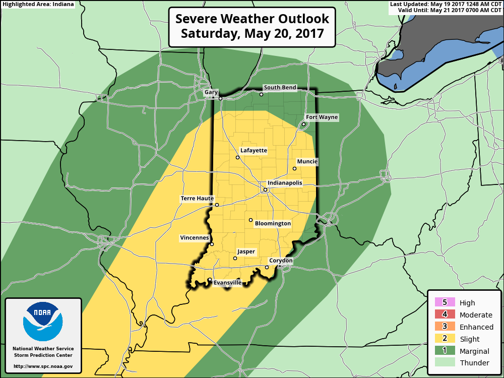
Unfortunately, the long race and Memorial Day weekend won’t be rain-free, but it also won’t be a wash-out. Most widespread thunderstorm activity should arrive Saturday evening into Sunday morning and some of these could become strong to severe. The current Day 3 (Saturday) Outlook from the Storm Prediction Center places central and southern portions of the state under a Slight Risk.
 While we can’t completely rule out an afternoon shower or storm Sunday, the most widespread activity should occur during the morning hours- before race time. Stay tuned. We’ll turn cooler early next week…
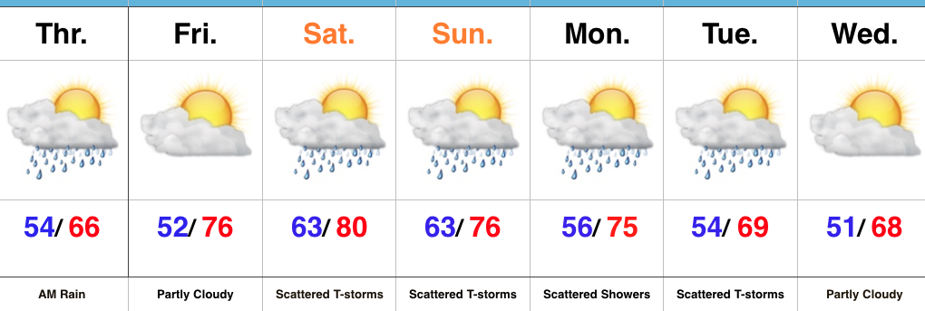
Upcoming 7-Day Precipitation Forecast:
The Storm Prediction Center includes portions of the state, including Indianapolis, under a Slight Risk of severe weather today and Saturday.
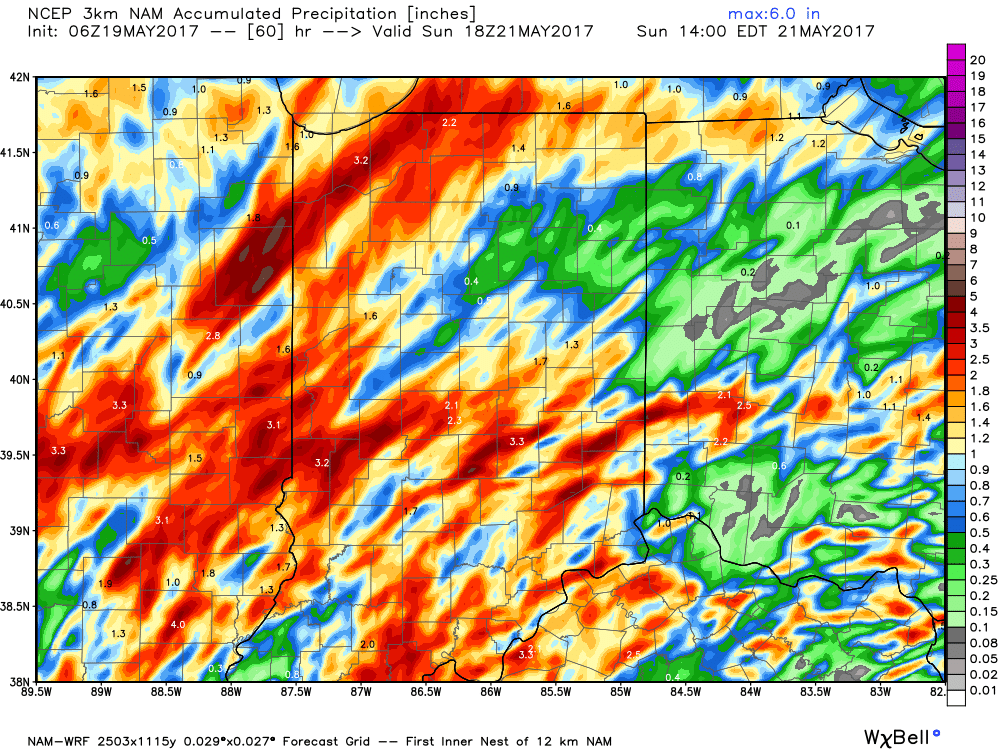
 The culprit is a stalled frontal boundary that lies across the center of the state. This front will “bobble” around from time to time over the next 24 hours before lifting back north as a warm front Saturday evening. Accordingly, expect a significant temperature spread from north to south today and periods of showers and thunderstorms scattered about central Indiana. With high precipitable water values, localized heavy rains are expected, but, as mentioned, this won’t be a “uniform” event and there will be “haves and have nots.” Some neighborhoods can expect to pick up a 2-3 inches of rain between now and Sunday afternoon. Greatest severe threats include large hail and damaging straight line winds with storms, but we’ll also have to monitor things for the potential of a couple rotating storms as well.
 Highlights:
Flooding Concerns Remain High…Another slug of moisture will lift north through central Indiana this afternoon into the nighttime hours. Locally heavy rain will result in big flooding concerns as saturated soils are in place and many creeks and streams are already out of their banks. Throw in an additional 1″-2″ with locally heavier totals and you have the makings of a dangerous flood situation into early week. If that wasn’t enough to be concerned about, we’ll also have to watch how things evolve closely this afternoon for the potential of severe thunderstorms. Damaging straight line winds are of greatest concern.
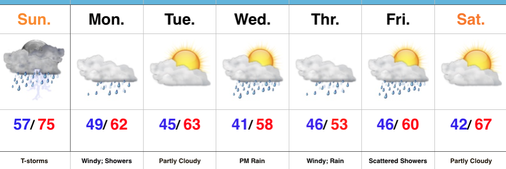
We’ll transition to a much cooler regime to open the new work week with gusty winds and showers continuing. Temperatures will fall through the 50s during the day. Jackets will be required!
Tuesday will provide a brief break from the wet weather and we should also introduce some sunshine for a while. Unfortunately, we won’t have much time to dry out as a wet, windy, and chilly storm is brewing Wednesday evening into Thursday. Widespread rain (some heavy) will combine with a raw easterly wind and temperatures in the 50s to lead to a rather miserable Thursday.
While shower chances remain early Friday, the theme heading into next weekend is a drier one and we should finally enjoy very pleasant weather by Saturday.
Upcoming 7-Day Precipitation Forecast: