Weekly #AGwx And #Severe Outlook…

Weekly Highlights:

I. Additional threat of late season frost/ freeze early in the forecast period.

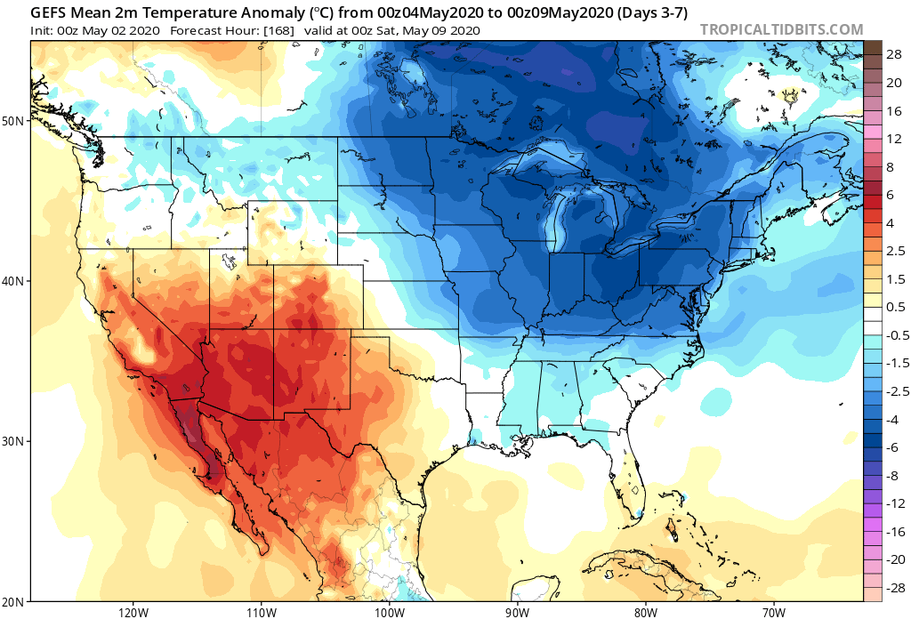
II. Transition in the pattern midweek signals a significant flip from the record chill across the East to one much more typical for mid-late May. Meanwhile, the West will turn much cooler.

A transition in our overall weather pattern will lead to a return of wet weather mid-late week, including multiple rounds of t-storms from the Plains into the Ohio Valley.
7-day rainfall should run between 1.75″ and 2.25″ with locally heavier amounts across central Indiana.
While the period will run cooler than normal, it’s because the first few days this week will run so far below normal. We’ll actually warm significantly mid-late week, however, the deviation from normal won’t be enough to tip the scale from the week being cooler overall across the Plains and East.
A couple gusty storms are possible across central and eastern IN this afternoon. We’ll also have to closely monitor late week for the threat of additional strong thunderstorms.

Forecast Period: 05.10.20 through 05.17.20

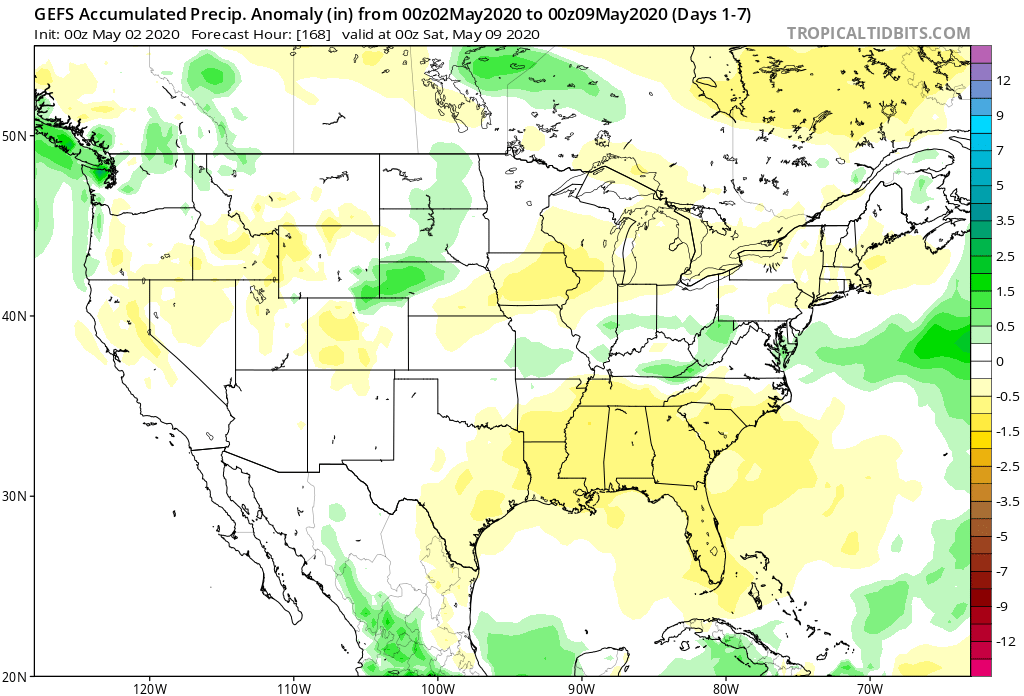
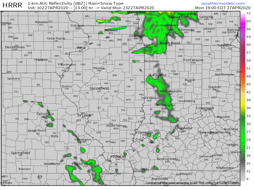
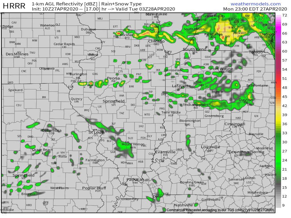
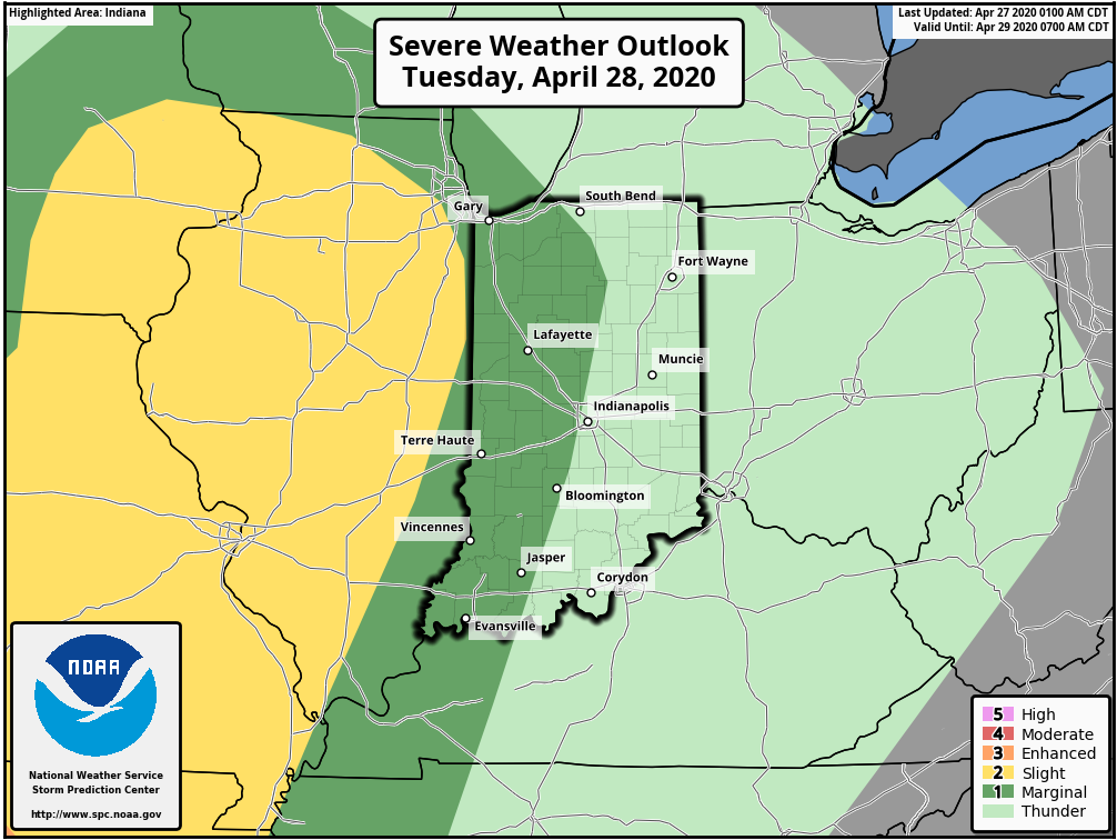
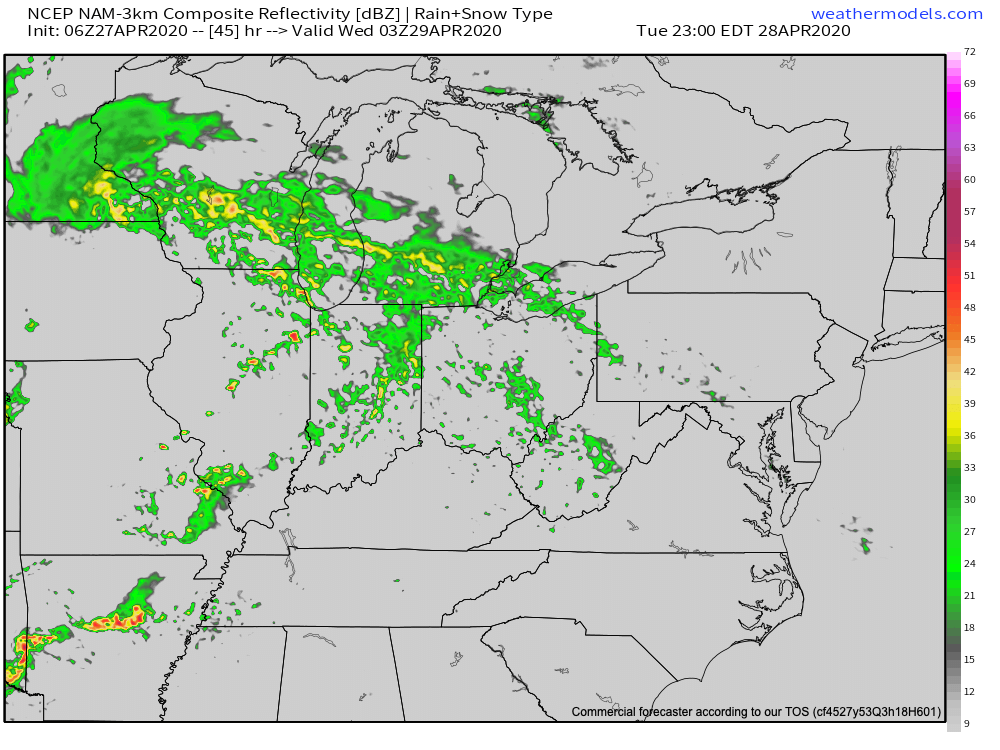
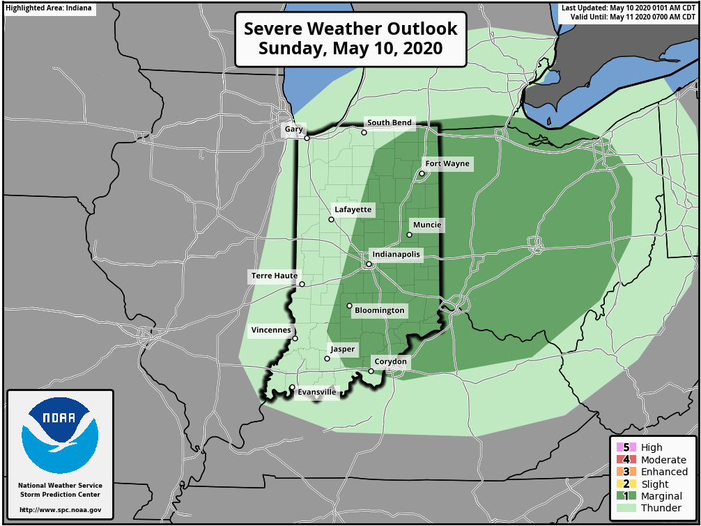
An area of low pressure and associated cold front will blast across the Ohio Valley during the next 24 hours. Ahead of the front, scattered showers are already entering the state from the west this morning. As we progress into the afternoon, we’ll watch for the potential of a couple skinny lines of thunderstorms try to develop across central and eastern parts of the state. A couple of these storms could quickly pulse to strong – severe levels and pose a threat of damaging straight line winds and hail. Once the front scoots to our east, we’ll notice a much colder (yet again) northwesterly breeze and drier conditions to open the work week. There will be a threat of another frost and freeze by Tuesday morning. Patchy frost is also possible Wednesday morning, especially across east-central parts of the state.

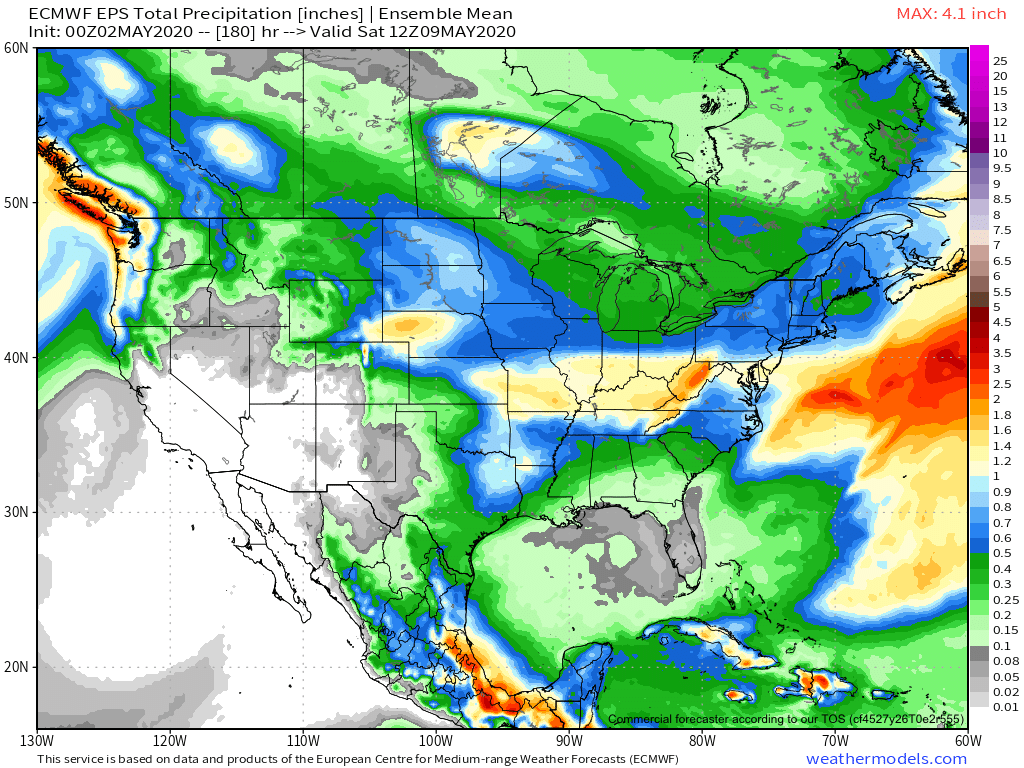
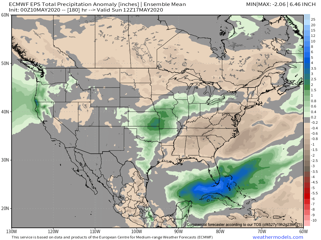
Thereafter, our region will undergo a rather significant flip in the overall pattern. As a result, an airmass much more typical of mid-May will engulf the eastern portion of the country. With the significantly warmer conditions will also come a few rounds of rain and thunder during the mid-late week stretch. Locally heavy rain is likely towards the end of the period including the threat of additional strong thunderstorms in the Thursday-Saturday time frame.

Weekly #AGwx And #Severe Outlook…

Weekly Highlights:

I. A cold front will settle south into a warm and at least marginally unstable environment tonight into early Sunday morning. This will result in a rather rapid expansion of thunderstorms across the central Ohio Valley tonight.

II. The next big item has to do with the unseasonably cold airmass that will unload into the eastern half of the country, but this is more of a late Week 1 into Week 2 situation.

Unseasonably dry conditions will continue to allow the Deep South to dry out over the upcoming week. Meanwhile, the Great Lakes region also should run drier than normal.

Across immediate central Indiana, we’re targeting the upcoming 7-day period to produce between 1.5” and 2” of rain and most of that will fall tonight-early Sunday morning.
A highly amplified pattern will emerge late in the forecast period resulting in the overall 7-day period tilting towards a cooler than average one. Even colder air is scheduled next weekend into Week 2.
The best chance of a few strong to severe storms will take place late tonight into early Sunday morning as a cold front settles south into a briefly warmer/ unstable air mass.

Forecast Period: 05.02.20 through 05.09.20

Most of our Saturday will feature dry and pleasant conditions. It’ll be a great day to get caught up on yard work around the house before things take on a stormy turn tonight. A cold front will settle into the briefly warmer and more humid air mass and will ignite thunderstorm development by late evening. A few of these storms will likely become strong to severe late evening into the overnight period, including the potential of large hail and damaging wind gusts. Once the front settles to our south, the convection will also move south and out of our area mid-late Sunday morning. Beforehand, a swath of 1” rains are likely throughout central Indiana with a few locally heavier totals.

There will then be a couple of additional cold fronts to track through the upcoming week: Monday night into Tuesday and again Friday into Saturday. Both fronts should provide additional rain chances during that time frame followed by cooler air.

It’s the weekend front that will usher in more of a winter-like feel including the threat of late season frost/ freeze conditions during the 7-10 day period. We may have not even seen the last of snow for the season…

Week-Ahead Outlook; Additional Early-May Chatter…

We may only have a few days left in April, but widespread frost is being reported across north-central into east-central Indiana (yet again) with most across the region in the lower to middle 30s this morning.

Sunshine will dominate to start our Monday before mid and high level clouds increase this afternoon into the evening hours. Eventually these clouds will produce scattered showers by evening (targeting a 6p-7p arrival into central Indiana).

Initially these showers should be very light and scattered in nature, but heavier rain and embedded thunder will develop during the overnight hours.

Showers and embedded thunder will exit Tuesday morning and most of the day will be rain-free, including a return of sunshine. This will help boost high temperatures into the lower 70s Tuesday! Unfortunately, an approaching cold front will lead to a return of storms Tuesday evening and much cooler air by midweek. A few of the storms could reach strong to severe status Tuesday night with the primary concern being damaging wind and large hail.

Showers and thunderstorms will return Tuesday night. A few of these may be strong to severe.

The cold front will sweep through the area Wednesday followed by a cut off upper low “wobbling” around the Ohio Valley Wednesday night into Thursday. This will lead to windy, showery, and much cooler conditions for midweek. In fact, temperatures Thursday will likely fall into the 40s during the daytime.

By the time all is said and done, we think most central Indiana communities can expect between 1.25″ and 1.75″ of rain, but there will be some locally heavier amounts in excess of 2″.

Major improvements are ahead as we get set to close the work week. High pressure will briefly build into the area, supplying plentiful sunshine and warmer conditions Friday.

The warmth will persist into the weekend and this morning’s video update dives into the longer range.