Weekly #AGwx And #Severe Weather Outlook…

I. Heat and humidity builds as we move through the 2nd half of the week.

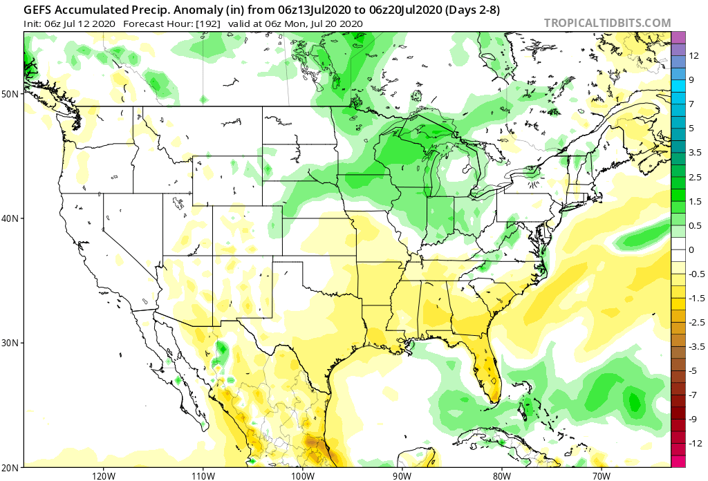
II. Pattern once again turns active and unsettled mid and late week.

Seasonable temperatures will rise to slightly above normal levels once to mid week, continuing into the weekend. As a whole, the period will run slightly above normal for central Indiana.
The 7-day period should feature above normal rainfall for central Indiana.
We forecast a total of 1″ to 2″ of rain for central Indiana between now and next Sunday with locally heavier totals.

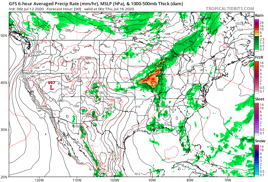
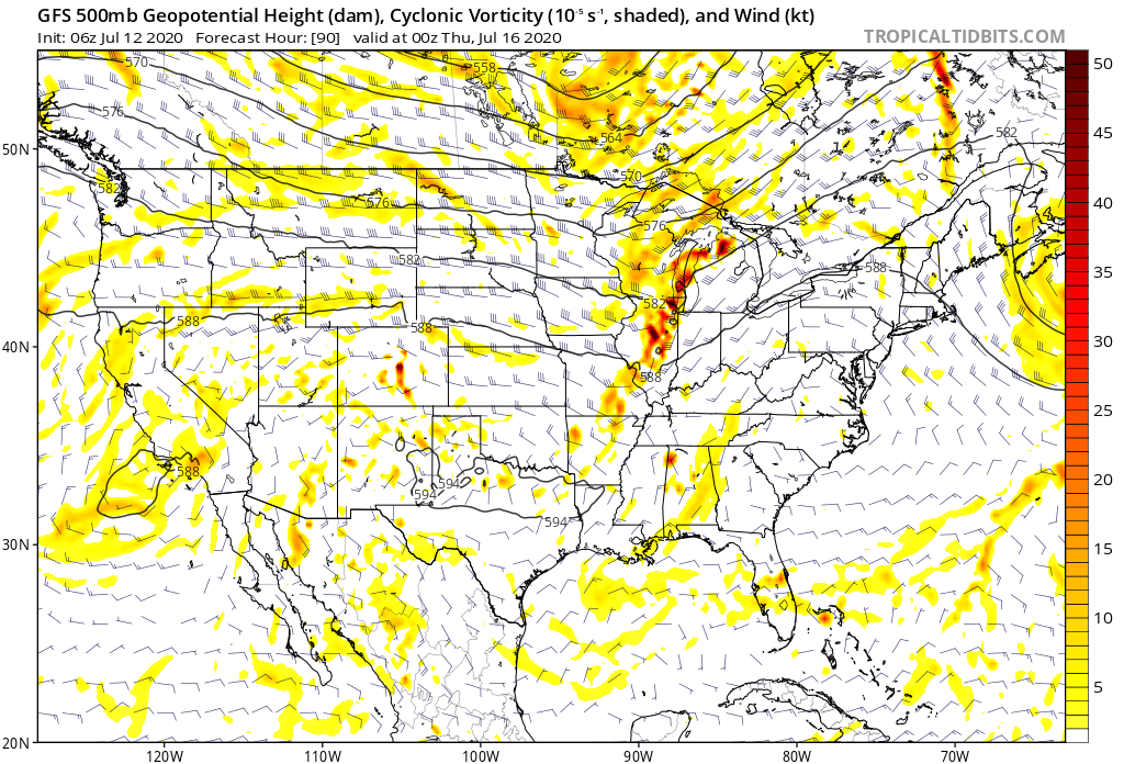
Though the Storm Prediction Center doesn’t currently have a Day 4 severe weather risk highlighted, we need to keep close eyes on this feature for the potential of strong to severe thunderstorms late Wednesday. Large hail and damaging winds are of greatest concern.

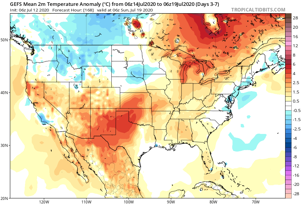
Forecast Period: 07.12.20 through 07.19.20

Additional scattered showers and thunderstorms will fire today but shouldn’t be nearly as intense or widespread as what last night delivered. We’ll then welcome a couple of days of cooler, less humid air with dry conditions. Enjoy as the heat, humidity, and storms will return by midweek. In fact, as mentioned above, the potential is present for some stronger storms late Wednesday and it wouldn’t surprise us if the Storm Prediction Center includes portions of the region in a severe weather risk over the next day or two for this threat. This will come on the leading edge of hotter and more humid weather for the 2nd half of the week, continuing into next weekend. As we look longer range (Week 2 time frame), the upper level ridge is expected to retrograde west and open us up to a northwesterly flow aloft. There are strong signals this will lead to a rather busy time of things as we wrap up July, including above to well above average rainfall. Before this takes place, we’re likely looking at another 6-7 day stretch of highs in the lower 90s.

Weekly #AGwx And #Severe Weather Outlook…

I. Significant heat wave builds from the Plains into the Ohio Valley and Great Lakes.

II. Heavy tropical downpours fall across the Southeast as a surface low meanders around the region early in the period.

Significant heat will bake the central Plains into the Great Lakes and Ohio Valley this week. Meanwhile, chilly conditions will persist across the Northwest. The Southeast will run slightly cooler than normal.
A wet pattern will develop this week across the Southeast region. Wetter than normal conditions will continue across the Northern Plains, as well. Dry conditions can be expected across the OHV and Great Lakes.
Unless you find yourself under an isolated strong storm, most of central Indiana can only expect between 0.10″ and 0.25″ of rain over the 7-day period.
Quiet conditions can be expected, locally, with respect to severe potential. That will be another story entirely across the Northern Plains over the next few days, however.

Forecast Period: 07.04.20 through 07.11.20

A relatively quiet period of weather can be expected across not only central Indiana, but all of the Ohio Valley over the upcoming 7-days as a strong ridge of high pressure dominates our region. This will lead to a significant and prolonged period of hot and increasingly humid conditions, including a consecutive stretch of 90° + highs to the likes of which we haven’t seen since the infamous summer of 2012. If planning time outdoors, build in frequent breaks. Overall dry conditions are also expected this week. The exception to this will be the opportunity of widely scattered storms developing in the prime heating hours (afternoon and evening each day). Count yourself lucky if you get under one of these storms. Unfortunately, some neighborhoods may go the entire week without a drop of rain.

Have a safe and happy Independence Day weekend, friends!

Weekly #AGwx And #Severe Weather Outlook…

I. Recent wet pattern remains intact.

II. Persistent hot, muggy regime takes us into the holiday weekend.

Temperatures will run above to well-above normal from the Plains into the Great Lakes and Northeast this week. The Rockies and points west can expect unusually chilly conditions.
Wetter than normal conditions are expected across the southwestern OH Valley into the TN Valley this week, along with the northern Rockies and New England.
We forecast 7-day rainfall totals for central IN to fall within the 1.75″ to 2.50″ range with locally heavier amounts.
In this pattern it won’t take much to have one or two storms pulse to severe levels, but widespread severe storms aren’t expected, locally. The biggest concern from any stronger storm that does form will be centered around damaging straight line winds.

Forecast Period: 06.28.20 through 07.05.20

A stationary frontal boundary will remain draped across the region until Tuesday night before getting a slight “nudge” off to the southwest Wednesday. The warm and humid pattern in place today will remain locked into the area straight through the holiday weekend (with a small break in humidity midweek). Periods of hefty thunderstorms can be expected- most numerous during the afternoon and evening hours. With such high moisture content in the air, locally heavy rainfall is expected at times. This “rinse and repeat” forecast will begin to change up by the holiday weekend as ridging builds overhead. While this won’t help us with the heat or humidity, this will reduce rain chances. Instead of scattered to numerous coverage, we’ll be talking about isolated coverage for the holiday weekend, itself. Most will stay dry. By this time frame, we’ll monitor the goings on to our south as a cut off low keeps the TN Valley into the Southeast region unsettled with more widespread storm coverage for the holiday weekend.

Weekly #AGwx And #Severe Weather Outlook…

I. Unseasonably cool weather dominates the area to open the period with a late warming trend.

II. Widespread dry conditions persist through the upcoming week.

Between the cool pattern to open the period and warmth to end, temperatures will balance out very close to “average” for the period as a whole.
The forecast period will run much drier than normal from the Plains and points east. The one exception? Along the Carolina coast, thanks to a stalled cold front.
We’re only forecasting 0.10″ to 0.25″ over the upcoming 7-day period across central Indiana.

Forecast Period: 06.13.20 through 06.20.20

A very quiet weather pattern is ahead through the forecast period. A weak disturbance will move southeast this morning across the region. While northern parts of the state picked up measurable rainfall this morning, most of this will scoot east of immediate central Indiana. This system will also serve to reinforce the cool pattern in place into early parts of next week. In fact, overnight lows tonight will fall into the 40s as far south as central Indiana. Anyone else craving fall?! The pattern beyond will feature a warming trend along with continued dry weather. Heat and humidity will build in earnest late in the period along with an opportunity for scattered showers and thunderstorms next weekend ahead of an approaching cold front. Between now and then, enjoy the quiet conditions.