Category: Record Cold

VIDEO: Winter Comes Knocking…

You must be logged in to view this content. Click Here to become a member of IndyWX.com for full access.  Already a member of IndyWx.com All-Access?  Log-in here.

Permanent link to this article: https://indywx.com/2019/11/06/video-winter-comes-knocking/

January-Like Cold Inbound Next Week; What Awaits Thereafter?

“Normals” for January includes highs in the middle 30s and lows in the upper 10s to lower 20s across central Indiana. Early to middle parts of next week are forecast to feature highs in the upper 20s to around 30 and lows in the middle 10s. Yes, these temperatures will challenge records as a truly impressive arctic invasion claims next week’s weather headlines.

Record cold is ahead next week.

A lot of this has to do with the sea surface temperature (SST) configuration across the northern Pacific. We’ve been focusing in on the warmer anomalies across the north and northeastern Pacific and tendency for this to drive a persistent ridge across NW NA since late summer. That persistent NW NA ridge leads to a persistent trough downstream and the associated cold pattern we’re now looking at. As our Winter Outlook suggests, we think this overall pattern repeats itself throughout the majority of the months ahead.
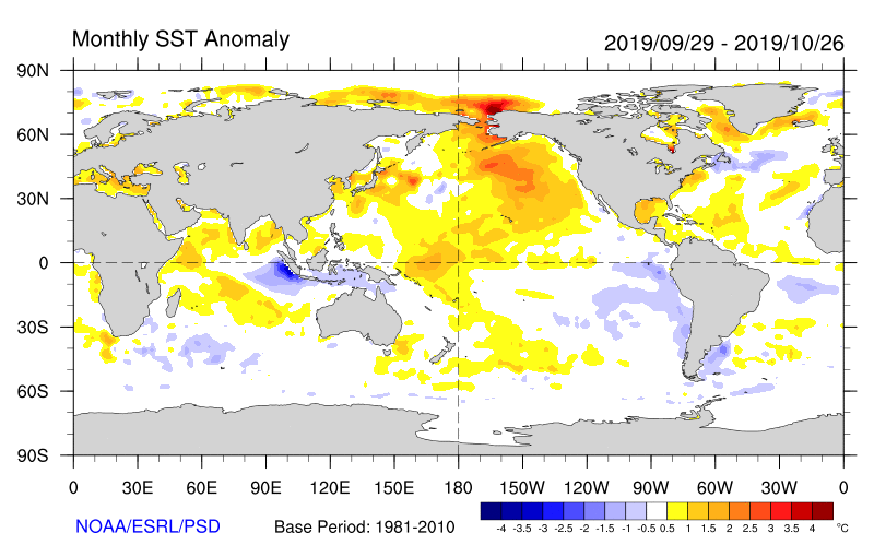
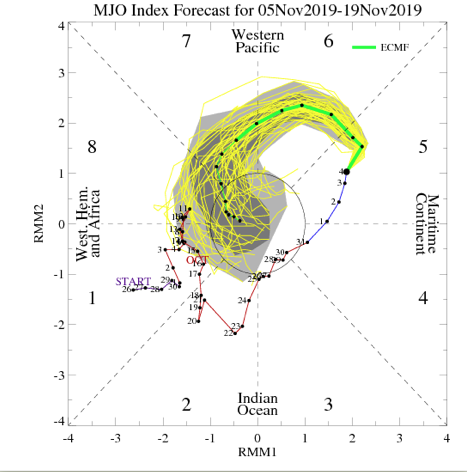
As we look more “immediate term,” what do teleconnections and the MJO tell us about the overall pattern moving past the middle of November? Well, to start, the highly amplified MJO is forecast to roll into Phase 7 around mid-month. This suggests the colder than normal pattern persists.
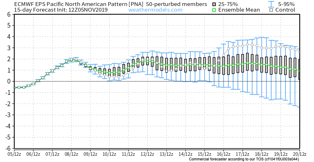
The EPO is forecast to remain negative while the PNA remains positive into and through the mid month period. Both argue for continued cold.

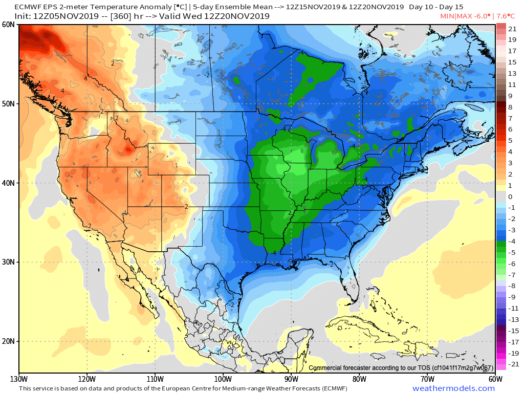
To no surprise, the latest long range data continues to drill unseasonably cold air south into our portion of the country and a large majority of the eastern portion of the Lower 48 in the Weeks 2-3 time period. Snow opportunities will undoubtedly follow with this kind of pattern.
Buckle up…

Permanent link to this article: https://indywx.com/2019/11/05/january-like-cold-inbound-next-week-what-awaits-thereafter/

VIDEO: Impressive Shot Of Arctic Inbound…

You must be logged in to view this content. Click Here to become a member of IndyWX.com for full access.  Already a member of IndyWx.com All-Access?  Log-in here.

Permanent link to this article: https://indywx.com/2019/11/05/video-impressive-shot-of-arctic-inbound/

VIDEO: Record Cold On The Table; What About Snow Chances?

You must be logged in to view this content. Click Here to become a member of IndyWX.com for full access.  Already a member of IndyWx.com All-Access?  Log-in here.

Permanent link to this article: https://indywx.com/2019/11/04/video-record-cold-on-the-table-what-about-snow-chances/

VIDEO: Still Worth Keeping A Close Eye On Thursday-Friday; Potential Record Cold Before Mid-Month?

You must be logged in to view this content. Click Here to become a member of IndyWX.com for full access.  Already a member of IndyWx.com All-Access?  Log-in here.

Permanent link to this article: https://indywx.com/2019/11/03/video-still-worth-keeping-a-close-eye-on-thursday-friday-potential-record-cold-before-mid-month/

VIDEO: All-Access Long Range Update…

This evening’s long range video update discusses the pattern drivers behind the late-March weather pattern…

You must be logged in to view this content. Click Here to become a member of IndyWX.com for full access.  Already a member of IndyWx.com All-Access?  Log-in here.

Permanent link to this article: https://indywx.com/2019/03/04/video-all-access-long-range-update/

Bitter Cold Gives Way To Another Accumulating Snow Event; Weekend Storms?

It’s a frigid start to the day, especially by March standards. With a fresh snow cover down, many reporting sites are now approaching zero. Officially, Indianapolis is down to 4 (F) as of this update at the 7a hour. For the most part, dry conditions will prevail today, but we could notice a couple of very light snow showers/ flurries at times this morning.

An upper level disturbance will pass through here Tuesday and again could be enough to ignite light snow showers.

The primary story through midweek is the cold as highs don’t make it above freezing until Friday afternoon. With the increasingly high and more powerful March sun angle, that’s another impressive feat.

Attention will shift to the threat of a stripe of accumulating snow Thursday evening into Friday.

As this upper level wave scoots southeast out of the central Plains and across the Ohio Valley, a band of accumulating snow will occur to the north and northeast of the track. As things stand now, we expect snow to build in here Thursday evening, continuing into Friday. While we still have time to watch things unfold, this is the kind of system that could deposit a few/ several inches of wet snow. Stay tuned.

Just as soon as we get rid of our late week snow maker, a new storm system will approach this weekend with the threat of heavier rain and embedded thunder late Saturday into early Sunday.

Rainfall totals of 0.75″ to 1.25″ are possible with our weekend system before precipitation ends as wet snow showers/ flurries next Sunday.

We’ll have an updated video discussion this evening looking more in-depth at the long range pattern… Make it a great Monday!

Permanent link to this article: https://indywx.com/2019/03/04/bitter-cold-gives-way-to-another-accumulating-snow-event-weekend-storms/

VIDEO: Updated Thoughts Around This Weekend’s Winter Storm And The Pattern Through March…

Here’s our latest thinking around this weekend’s winter storm and a long range update through the month of March…

You must be logged in to view this content. Click Here to become a member of IndyWX.com for full access.  Already a member of IndyWx.com All-Access?  Log-in here.

Permanent link to this article: https://indywx.com/2019/02/28/video-updated-thoughts-around-this-weekends-winter-storm-and-the-pattern-through-march/

Wednesday Evening Video Update On The Upcoming Weekend Winter Storm…

You must be logged in to view this content. Click Here to become a member of IndyWX.com for full access.  Already a member of IndyWx.com All-Access?  Log-in here.

Permanent link to this article: https://indywx.com/2019/02/27/wednesday-evening-video-update-on-the-upcoming-weekend-winter-storm/

All-Access Long Range Update: Walking Through March…

Recently, a “transient” pattern has dominated. This has kept any sort of long-lasting cold at bay and resulted in above normal precipitation. As we get set to close out February and welcome in a new month, a pattern change is on the horizon.

This overall shift in the pattern will drive a more sustained and significantly colder than normal regime southeast. In short, cold is set to “overwhelm” the pattern through the first couple of weeks of March. In the most extreme case (especially if we can get snow down), we will be able to challenge records at some point during the 1st (10) days of the month.

In spite of a neutral to positive AO and NAO, a significantly negative EPO and MJO rumbling through the cold late Feb and early March phases look to trump the otherwise warm signals. We also can’t forget about the significant SOI crash. Let’s dig into some of the latest data:

CFSv2


Note the modeling spreading the cold out during the Weeks 2-3 time period before gradually modifying things as we move into the middle and latter portion of March. The mean storm track shifts to the east during the first couple of weeks of the month (pattern will likely be dominated by more snow vs. rain events during this time period) before wetter than normal conditions return for the 2nd half of the month.

JMA Weeklies

Week 1
Week 2
Weeks 3-4

Like the CFSv2, the model overwhelms the pattern with cold during the Week 2 time period. Also similar to the CFSv2, the JMA Weeklies bring ridging back into the East and associated warmth by mid-month. While we haven’t included the precipitation anomalies in this post, the model does bring wetter than normal conditions back into the area by mid-March.

European Weeklies

The NEW European Weeklies remain consistent from Monday’s update (and data above) in delivering a very cold 1st half of March. The core of the cold looks to be centered over the upper Midwest and Northern Plains, but temperatures for the balance of the first couple weeks of the month will likely resemble what we’d expect in late January or early February vs. March. While precipitation will likely run below normal (thanks to the cold pattern), the model deliver above normal snowfall during the period. As we move into the 2nd half of the month, warmer (and wetter) conditions are shown to return.

Given all of the above, we expect the primary upper air pattern to feature a central and eastern trough through the 1st half of March before that trough settles into the West during the 2nd half of the month. This will open up the eastern portion of the country for not only warmer air, but a return of moisture-laden storm systems and the potential of strong-severe storms at times.

Permanent link to this article: https://indywx.com/2019/02/21/all-access-long-range-update-walking-through-march/

IndyWx.com