VIDEO: Hello December…
You must be logged in to view this content. Click Here to become a member of IndyWX.com for full access. Already a member of IndyWx.com All-Access? Log-in here.
You must be logged in to view this content. Click Here to become a member of IndyWX.com for full access. Already a member of IndyWx.com All-Access? Log-in here.
 Highlights:
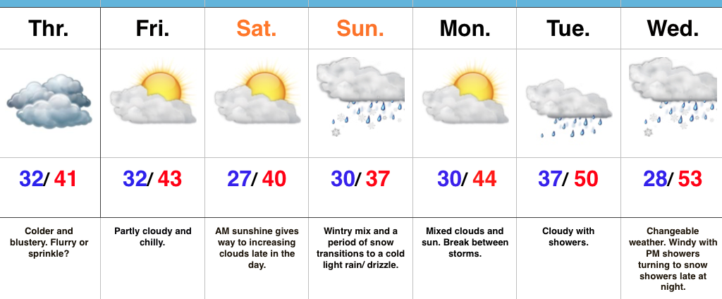
Feeling More Like The Season…Colder air began to press into central IN Wednesday afternoon. That was a hint of what we’ll deal with to wrap up the work week. While nothing too far from normal, it’s definitely going to feel colder when compared to the past couple days. A sprinkle or snow flurry is possible Thursday- especially across northern portions of the state. Friday and Saturday will be dry, but continued chilly.
Our next storm system will approach the region Saturday night into Sunday. A wintry mix, including a period of snow, is a good bet Sunday morning before enough warm air advection leads to a transition to a chilly light rain or drizzle. It’ll be a raw day. Needless to say with model data still in disagreement, we’ll continue to keep a close eye on Sunday’s forecast and update accordingly.
Next week will continue the fast-paced time of things, with a double-barrel storm system taking aim on the region Tuesday into Wednesday. Showers will push northeast Tuesday followed by another round of rain Wednesday. The coldest air of the season looms just beyond this forecast period. Though timing is an issue that will have to be fine tuned, our air mass should grow cold enough to allow for precipitation to transition to snow showers late Wednesday night. Stay tuned.
Upcoming 7-Day Precipitation Forecast:
You must be logged in to view this content. Click Here to become a member of IndyWX.com for full access. Already a member of IndyWx.com All-Access? Log-in here.
 Highlights:
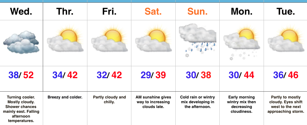
Temperatures Trend Downward…Moisture will lift northeast late tonight into Wednesday and could push light showers as far west at the Indy metro late tonight and early Wednesday morning. Better coverage of showers will be found across east and southeast portions of the state Wednesday morning. While highs Wednesday should top out in the lower to middle 50s for most central IN neighborhoods, temperatures will begin to slip during the afternoon and evening hours as colder air slowly oozes in. The cooler trend will continue as we wrap up the work week.
All eyes will then shift to the weekend and a potential storm system Sunday. Model data continues to differ significantly on the all-important details. For now we’ll spare you from the nerdy meteorological lingo 😉 and lean towards increasing clouds Saturday evening with a cold rain or a wintry mix developing Sunday afternoon. Should more energy come out and “phase,” this will become a system that will require more attention in the days ahead. Stay tuned. Any early wintry mix will depart Monday morning and we’ll briefly dry out into Tuesday.
By that point, another storm system will require our attention later next week. Additional wintry prospects loom along with the first true shot of Old Man Winter just beyond this particular forecast period.
Upcoming 7-Day Precipitation Forecast:
 Highlights:
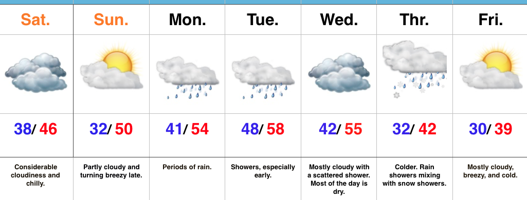
Sunshine Slowly Returns…We’ve been socked in with clouds, chilly conditions, and overall gloomy weather for the past several days. Thankfully, sunshine will eventually return this weekend. Today has started with overcast skies, but slow improvements should provide an increasingly sunny sky as the day wears on. Seasonable temperatures can be expected today.
The second half of the weekend will feature more in the way of sunshine, but our next storm system will be awaiting on deck by this point. Southwest winds will turn increasingly breezy by the PM and clouds will quickly increase yet again. Those clouds will yield rain as early as the wee morning hours Monday (well before sunrise). Periods of heavy rain can be expected Monday and even a thunderstorm by afternoon/ evening.
Most of the heavy rain will fall Monday, but we’ll maintain mention of showers in our forecast Tuesday and Wednesday. A second wave of low pressure will develop along a pressing front the middle of next week and spread moisture northeast. The “leader” storm system is much easier to forecast than the “follower” in this scenario. The details are muddy at this point concerning the extent of how far west precipitation can make it. Know that we’re keeping a close eye on things. For the sake of this particular forecast, we’ll include mention of rain showers mixing with snow showers as colder air moves in Thursday. Stay tuned.
The end of the week will feature a colder trend as we usher in December.
One final item on the agenda this morning- with this being Iron Bowl Saturday, we can’t leave you without wishing you an energetic WAR EAGLE!
Upcoming 7-Day Precipitation Forecast: